Surveying
Surveying involves the precise measurement and recording of locations and elevations on Earth. This technique forms the foundation for projects in fields such as infrastructure, construction, and spatial planning. Whether it involves staking out construction boundaries or collecting geodata for maps and analyses—precision is essential.
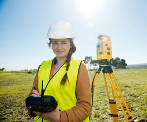
In a world that is becoming increasingly dependent on reliable geospatial information, knowledge of surveying is indispensable. With modern instruments such as GPS, total stations, and level meters, measurements are performed faster and more accurately than ever before.
Surveying is not only technical but also creative: you literally help shape our physical environment. From urban development to environmental management—your measurements make a difference.
What will you learn in this Blended Learning course?
In this course, you’ll have the opportunity to explore the world of surveying and discover how accurate measurements contribute to shaping our living environment. You’ll learn about advanced techniques and measuring instruments such as GPS, total stations, and digital level meters. This knowledge is indispensable in applications such as infrastructure, spatial planning, and environmental management.
The course provides a solid theoretical foundation that teaches you how geographic data is collected, analyzed, and applied in a variety of situations. You’ll delve into topics such as coordinate systems, elevation measurements, and the role of geospatial data in mapping and project planning.
Although this online course does not involve hands-on work with measuring instruments, you will gain a clear understanding of how they function and are used in the field. Through interactive assignments, simulations, and practical examples, you will develop insights that are directly applicable in the professional field.
You’ll learn how to process geospatial data using software like AutoCAD, how to interpret survey results, and how accurate data contributes to reliable decision-making. You’ll discover how you can use this knowledge and these skills to make a valuable contribution to sustainable and innovative projects.
Why choose this Basic Surveying course?
Blended learning combines independent online learning with in-depth content, allowing you to build knowledge about surveying, measurement strategies, and the use of modern technology in a flexible and accessible way. The online modules give you the freedom to learn wherever and whenever it suits you. You’ll take interactive lessons on geodata, coordinate systems, and how surveying instruments such as GPS, total stations, and digital levels work. This way, you’ll discover how geographic data is collected and applied in spatial projects in fields such as infrastructure and environmental management.
During the online learning modules, you’ll apply theoretical knowledge directly to recognizable real-world situations. You’ll analyze realistic scenarios, delve into measurement errors, and learn how to correctly process measurement data using software such as AutoCAD. Additionally, you’ll gain insight into how surveying contributes to creating reliable maps, planning projects, and making informed decisions within a geospatial context.
The combination of flexible online learning and practical applications ensures that you not only understand how surveying works but also how to effectively apply this knowledge. After this course, you will have a solid foundation in geodata, measurements, and analysis. This will prepare you well to contribute to projects in the fields of urban development, infrastructure planning, or nature conservation.
Would you also like to practice with a Total Station in a hands-on setting? Then we recommend the 3-day Surveying course, which covers both theory and practice in depth. This course is a valuable addition for anyone who wants to delve deeper into practical applications after completing this blended learning course.

