BGT Basic

How can you be sure you’re using BGT data correctly in your work? In this one-on-one course, you’ll learn step by step how to reliably interpret and apply BGT data for spatial planning and geo-ICT projects. With personalized guidance, online modules, and hands-on assignments, you’ll develop practical skills that will help you avoid mistakes and work confidently with geodata.

Large-Scale Topography Database

The Large-Scale Topography Basic Register (BGT) is an official digital map of the Netherlands, in which objects such as roads, rail lines, ditches, buildings, sites, and green spaces are recorded in a standardized manner. It is one of the government’s basic registers and provides up-to-date, reliable information about the physical environment.

The BGT is indispensable for organizations that work with geoinformation and geodata. Clear agreements on how data is recorded enable government agencies, engineering firms, and other parties to collaborate more effectively in planning, designing, and maintaining the built environment.

The BGT Basics course is intended for people who work with or want to start working in geo-ICT or spatial planning. During this BGT training, you will learn how the registry is structured, which government agencies provide data, and how to use this information in practice. Examples include projects in the fields of infrastructure, urban development, or public space management.

Upon completion, you will understand how the BGT works and will be able to independently apply the data in a variety of situations where geospatial data plays a central role.Geo-ICT Training Center, Nederland - Blended Learning BGT Basis

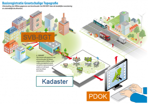
What will you learn in this Blended Learning course?

In this practical BGT training, you’ll learn how to actually apply this knowledge in your work. You’ll gain insight into the structure of the registry, the relevant laws and regulations, and the link to other basic registries such as the BAG and BOR. You’ll work with commonly used software in the world of geo-ICT and apply geodata in realistic situations such as spatial planning and infrastructure management. Through practical examples, you’ll learn how to collect, verify, and use BGT data to analyze and improve the physical environment. Whether you work for a municipality, an engineering firm, or another organization in the field of geoinformation, this blended learning course provides you with the knowledge and skills to effectively work with BGT data.

Why choose this BGT Basics course?

Blended learning combines independent online learning with practical, interactive sessions. This allows you to gain both theoretical knowledge and practical experience with BGT data, geo-ICT, and the application of regulations. You can complete the online modules at your own pace. They include interactive lessons on the structure of the Large-Scale Topography Basic Registry, the use of geodata, and the integration with other registries such as the BAG and BOR. You’ll learn how to consult, analyze, and apply BGT data within current work processes in the spatial domain.

You’ll apply what you learn immediately. During the practical online sessions, you’ll work with real BGT data. You’ll receive guidance from experienced trainers in the geo-ICT field. You’ll learn how to verify data for accuracy, how to link different registries, and how to apply geo-information to issues such as public space management and infrastructure planning. By practicing with realistic scenarios, you’ll develop practical skills. Skills that are immediately applicable in your daily work with geospatial data.

Flexibility and practicality. That combination makes this blended learning course powerful. You’ll not only learn to work with BGT and geo-ICT software, but also how to apply that knowledge effectively. After completing the course, you’ll be able to independently collect, assess, and use BGT data in a variety of situations. This allows you to make better-informed decisions based on reliable information about the physical environment.

Enroll

€395,- (VAT included)
  • Start: 2-hour online session
  • Self-study: Review course materials
  • End: 1-hour online session
Register for this course

You’ll receive 1-on-1 guidance. After signing up, our course coordinator will contact you to schedule your first session.

Leerdoelen

After completing this course, you will be able to:

  • Read and apply BGT data in geo-ICT projects.
  • Collect, verify, and process geodata.
  • Link BGT to registries such as BAG and BOR.
  • Work with geoinformation software for data analysis.
  • Use geospatial data for spatial decision-making.

Want to know more?

Do you have questions about the course content? Or are you unsure whether the course aligns with your learning goals or preferences? Would you prefer an in-house or private course? We’d be happy to help.

Frequently Asked Questions About Courses

After the course, you’ll have another two weeks to ask the instructor questions. Since the instructor is already teaching other courses, it’s best to email your questions to info@geo-ict.nl. Your question will be forwarded to the instructor, and you’ll receive a response within 24 hours.

If you’re a bit further along and encounter practical problems you can’t solve on your own, it’s best to use Online Support. You’ll spend one day online with the instructor and receive personalized one-on-one instruction. All your problems will be resolved, and you’ll have made significant progress.

  • Blended learning, also known as hybrid learning, is an educational method that combines traditional face-to-face classes with online learning materials and interactive sessions. This approach offers students flexibility and control over aspects such as the time, place, and pace of learning, while allowing them to benefit from direct interaction with instructors and fellow students. ​
  • At the Geo-ICT Training Center in the Netherlands, blended learning is implemented by having students study largely independently, supplemented by scheduled interactive sessions with an instructor. During these sessions, students can ask questions and discuss complex topics, which fosters a deeper understanding of the course material. All Blended Learning courses begin with a 2-hour online session. The instructor delivers presentations and assigns various exercises and assignments to the student. The student can then work on these independently. After a few weeks, another one-hour online session follows.

If you run into problems in practice that you can’t solve on your own, you have two options: you can sign up for a beginner or advanced course, or you can sign up for Online Support.

You’ll spend a day online with an instructor and receive personalized one-on-one instruction. All your problems will be resolved, and you’ll have made significant progress.


All courses are taught in person. Course hours are from 9:00 AM to 4:00 PM. Coffee, tea, lunch, and a laptop are provided.

Taking a course online is also possible, but we only offer hybrid courses in exceptional cases. If you wish to participate in a course online, please indicate this during registration—select “Online” as the location. If that is not possible, this course will only be offered on-site in Apeldoorn.

Yes, we do this regularly. Our instructor will come to your location and bring laptops for the participants. All you need to do is arrange a classroom at your location.

Please email your requirements to info@geo-ict.nl, and we will send you a quote. Once you’ve confirmed the order, our course coordinator will contact you to schedule the training days.

After each course, participants receive a link to our evaluation portal. There, you can share your feedback on what you liked and didn’t like about the course. We always do our very best, but of course, there may be times when you have a complaint. Click on “Complaints Procedure.” It explains what steps you can take. Geo-ICT Training Center, Netherlands is a member of the Dutch Council for Training and Education (NRTO).

After the course, we will email you a link to our evaluation portal. There, you can log in and fill out an evaluation form, and you can also download your certificate of participation.

Â