Coordinate Reference Systems and Spatial Data

How can you be sure your map is accurate? In this one-on-one course, you’ll discover why even a small error in the coordinate system can have major consequences for your geodata. You’ll learn how to effectively apply CRS and projections in QGIS, with personalized guidance, hands-on exercises, and online modules that take you step by step into the world of spatial data—so you’ll never doubt the accuracy of your map again.

Coordinate Reference Systems and Spatial Data

Anyone who works with geodata, maps, or spatial analyses knows that everything hinges on accurate location information. Coordinate Reference Systems (CRS) and spatial data together form the indispensable foundation of every geospatial application.

Geo-ICT Training Center, Nederland - Blended Learning Coördinaat Systemen

From geotagging to GPS routing and environmental studies: location plays a role in virtually every modern application. Time and again, it comes down to two questions: “Where am I?” and “How do I represent my data correctly?”

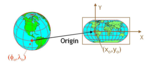
For the first question, you need a coordinate reference system that links locations to actual places on Earth. Because we live in a 3D world but usually create 2D maps, you need to project that data correctly—from spherical to flat.

To display your data correctly, you need to know what you want to show. Are you working with exact locations such as points or lines, or with raster data such as temperature or elevation? Making the right choice makes your analysis both understandable and useful.

In this course, you’ll learn how CRS works, how to apply spatial data correctly, and how to avoid errors that could skew your results. This will help you lay a solid foundation for any geospatial challenge.

What will you learn in this Blended Learning course?

In this blended learning course, you’ll discover how Coordinate Reference Systems (CRS) work. You’ll learn why they’re indispensable for processing and analyzing geodata. What’s the difference between geographic and projected systems? How do you apply EPSG codes? And how do you choose the right coordinate system for your geospatial project?

We’ll also dive into the world of map projections. You’ll discover the different types, their strengths and weaknesses, and how to select the right projection based on your objective. You’ll gain insight into how we transform our three-dimensional Earth into a two-dimensional map—an essential step in any GIS environment.

Data representation is also covered in depth. You’ll learn how raster and vector models work and when to use each one. The choice depends on what you want to analyze or visualize. You’ll also discover where to find reliable—and often free—geospatial datasets that you can use immediately in your work.

Finally, we bring everything together within Geographic Information Systems (GIS). You’ll practice interpreting, editing, and visualizing spatial data. This way, you’ll learn to perform accurate analyses and create maps that are truly accurate—free from the errors that often arise from incorrectly combined data or incorrect settings.

Why choose this Coordinate Reference Systems and Spatial Data course?

Blended learning combines independent online learning with practical, interactive sessions, so you gain both theoretical knowledge and practical experience with Coordinate Reference Systems (CRS) and the use of spatial data within GIS applications. The online modules give you the freedom to learn at your own pace and offer interactive lessons on coordinate systems, map projections, and spatial data processing. You’ll learn how to correctly apply different CRS, how to project geographic data onto a usable map, and how to prepare spatial datasets for accurate analysis.

During the hands-on online sessions, you’ll immediately put your acquired knowledge into practice. You’ll work with real geodata and receive guidance from experienced GIS specialists. You’ll learn how to perform coordinate transformations, apply EPSG codes, choose appropriate projections, and combine datasets without causing shifts or errors. By practicing with realistic scenarios, you’ll gain insight into how the correct application of CRS leads to reliable and consistent results.

The combination of flexible online learning and hands-on training ensures that you not only learn to work with CRS and spatial data, but also how to effectively apply them within professional GIS workflows. After this course, you will be able to independently analyze and apply coordinate systems, correctly interpret spatial data, and convert your data into clear and usable maps. This will enable you to make better-informed decisions within your field.

Enroll

€395,- (VAT included)
  • Start: 2-hour online session
  • Self-study: Review course materials
  • End: 1-hour online session
Register for this course

You’ll receive 1-on-1 guidance. After signing up, our course coordinator will contact you to schedule your first session.

Leerdoelen

After completing this course, you will be able to:

  • Recognize and apply different types of map projections
  • Describe what a geodetic reference point is and how EPSG codes are used
  • Determine when to use raster or vector formats in your spatial analyses
  • Find and apply suitable geospatial data sources
  • Correctly display and interpret spatial data in a GIS environment
  • Perform coordinate transformations and combine datasets without errors in QGIS

Want to know more?

Do you have questions about the course content? Or are you unsure whether the course aligns with your learning goals or preferences? Would you prefer an in-house or private course? We’d be happy to help.

Frequently Asked Questions About Courses

After the course, you’ll have another two weeks to ask the instructor questions. Since the instructor is already teaching other courses, it’s best to email your questions to info@geo-ict.nl. Your question will be forwarded to the instructor, and you’ll receive a response within 24 hours.

If you’re a bit further along and encounter practical problems you can’t solve on your own, it’s best to use Online Support. You’ll spend one day online with the instructor and receive personalized one-on-one instruction. All your problems will be resolved, and you’ll have made significant progress.

  • Blended learning, also known as hybrid learning, is an educational method that combines traditional face-to-face classes with online learning materials and interactive sessions. This approach offers students flexibility and control over aspects such as the time, place, and pace of learning, while allowing them to benefit from direct interaction with instructors and fellow students. ​
  • At the Geo-ICT Training Center in the Netherlands, blended learning is implemented by having students study largely independently, supplemented by scheduled interactive sessions with an instructor. During these sessions, students can ask questions and discuss complex topics, which fosters a deeper understanding of the course material. All Blended Learning courses begin with a 2-hour online session. The instructor delivers presentations and assigns various exercises and assignments to the student. The student can then work on these independently. After a few weeks, another one-hour online session follows.

If you run into problems in practice that you can’t solve on your own, you have two options: you can sign up for a beginner or advanced course, or you can sign up for Online Support.

You’ll spend a day online with an instructor and receive personalized one-on-one instruction. All your problems will be resolved, and you’ll have made significant progress.


All courses are taught in person. Course hours are from 9:00 AM to 4:00 PM. Coffee, tea, lunch, and a laptop are provided.

Taking a course online is also possible, but we only offer hybrid courses in exceptional cases. If you wish to participate in a course online, please indicate this during registration—select “Online” as the location. If that is not possible, this course will only be offered on-site in Apeldoorn.

Yes, we do this regularly. Our instructor will come to your location and bring laptops for the participants. All you need to do is arrange a classroom at your location.

Please email your requirements to info@geo-ict.nl, and we will send you a quote. Once you’ve confirmed the order, our course coordinator will contact you to schedule the training days.

After each course, participants receive a link to our evaluation portal. There, you can share your feedback on what you liked and didn’t like about the course. We always do our very best, but of course, there may be times when you have a complaint. Click on “Complaints Procedure.” It explains what steps you can take. Geo-ICT Training Center, Netherlands is a member of the Dutch Council for Training and Education (NRTO).

After the course, we will email you a link to our evaluation portal. There, you can log in and fill out an evaluation form, and you can also download your certificate of participation.

Â