SCRUM
SCRUM is an AGILE methodology that helps teams collaborate effectively and flexibly on projects. Instead of following a rigid, pre-determined plan, SCRUM involves working in short, well-defined work periods called sprints. At the end of each sprint, you deliver a concrete and usable result. This allows you to respond more quickly to changes and continuously improve your process and product.
A SCRUM team consists of three distinct roles: the Product Owner, the SCRUM Master, and the development team. Each role contributes to a smoothly running project. The Product Owner oversees the priorities, the SCRUM Master facilitates the process, and the team carries out the work. This clear division of tasks creates structure, ownership, and a high degree of collaboration.
SCRUM is now widely applicable: from IT and software development to marketing, education, and geospatial projects. It is a proven approach for organizations that want to be agile, achieve quick results, and continuously improve their processes.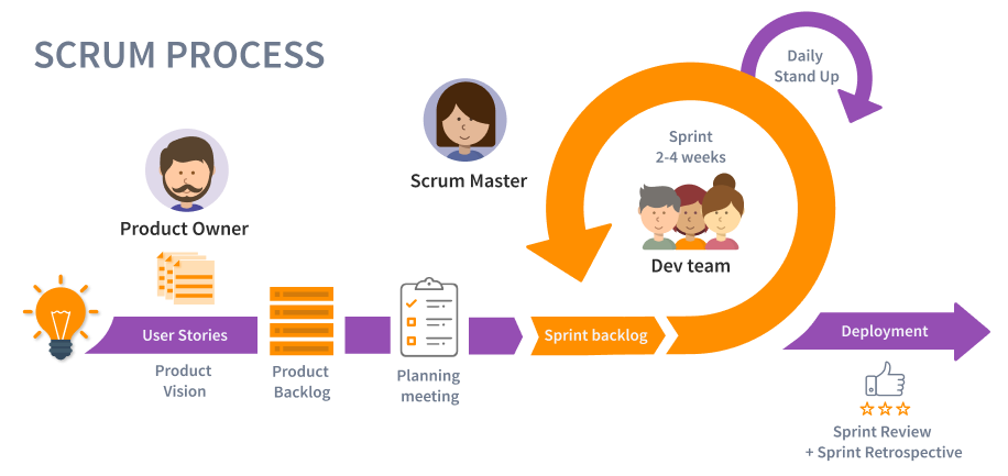
What will you learn in this Blended Learning course?
In this course, you’ll learn how to apply SCRUM to collaborate more effectively, achieve results faster, and gain better control over your projects. You’ll be introduced step by step to the key elements of SCRUM, such as sprint planning, retrospectives, daily stand-ups, and managing the product backlog.
You’ll also discover how the three core roles within SCRUM work together:
- Product Owner – sets priorities and maximizes the value of the team’s deliverables;
- Scrum Master – facilitates the process, supports the team, and removes obstacles;
- Development Team – works independently on solutions and delivers a working result after each sprint.
Does this blended learning SCRUM course also cover GIS? Yes! During the course, you’ll work with practical examples from the world of GIS system development. SCRUM is therefore not only explained theoretically but also applied in realistic situations within Geographic Information Systems (GIS). This way, you’ll experience how SCRUM works in projects involving geodata or geospatial software.
This course is designed for professionals who truly want to understand and use SCRUM in their daily work. Whether you work in IT, urban planning, geospatial applications, or another sector where agile working is valuable—you’ll learn how to effectively apply SCRUM in your practice.
Why choose this SCRUM Working course?
Blended learning in SCRUM Working combines self-paced online learning with practical, interactive sessions. This allows you to develop both theoretical knowledge and practical experience with agile working and the SCRUM methodology. The online modules give you the freedom to study at your own pace. They include interactive lessons on topics such as sprint planning, creating and managing the product backlog, conducting daily stand-ups, and guiding a project from idea to working result.
During the practical online sessions, you’ll immediately apply the knowledge you’ve gained. You’ll work with realistic real-world cases, including examples from the world of geodata and geospatial system development. Under the guidance of experienced SCRUM coaches, you’ll practice applying SCRUM in a team environment. This way, you’ll learn how to collaborate effectively, identify and resolve obstacles, and continuously deliver value in short, manageable cycles.
This combination of flexible online learning and practical application ensures that you not only know what SCRUM is, but also how to apply it to real projects. Upon completion of the course, you will have concrete skills that are immediately applicable in sectors such as IT, geoinformation, software development, and project management. This will enable you to adapt more quickly, collaborate more effectively, and achieve better results.

