In this course, you will learn how to use Cities: Skylines, an advanced city-building simulator, as a serious gaming tool. You will discover how to build realistic spatial scenarios that are not only visually compelling but also based on real GIS data and spatial principles. By combining geoinformation with the interactive capabilities of gaming, you create a powerful communication tool that makes complex policies accessible and promotes participation. After this course, you will be able to strategically deploy serious gaming within your organization or projects, allowing you to communicate complex spatial issues more effectively and build broader support for your plans and ideas. You will learn not only the technical aspects of working with Cities: Skylines, but also how to integrate this tool into your existing GIS workflows and communication strategies.
What is Serious Gaming?
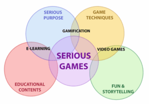
Serious gaming is the targeted use of game principles and technologies for non-entertainment purposes, such as education, policy-making, and decision-making. Unlike regular video games, serious gaming focuses on achieving specific learning objectives or solving concrete problems. It combines the educational aspect of simulations with the engagement and motivation that games can generate.
In the context of geoinformation and spatial planning, serious gaming offers unique opportunities:
- Visualization of complex systems: Games can make complex spatial processes and their interrelationships visible and understandable.
- Experience instead of abstraction: Instead of presenting abstract data and maps, serious gaming allows people to experience how decisions impact a dynamic system.
- Accessible participation: Games enable non-experts to participate in discussions about complex spatial issues.
- Scenario development: By simulating different scenarios, the long-term effects of policy choices can be made clear.
Cities: Skylines is a particularly valuable platform in this context. This city-building simulator combines an accessible interface with advanced simulation capabilities for traffic, the economy, pollution, water management, and social dynamics. The game offers a realistic approach to urban development, in which various systems are intertwined, just as they are in the real world.
By using Cities: Skylines as a serious gaming tool, you can translate GIS data into an interactive, visually appealing environment that invites experimentation and discussion. This opens up new possibilities for communicating spatial issues and engaging diverse target groups in your projects.
Benefits of Serious Gaming in Spatial Issues
Using serious gaming—and specifically Cities: Skylines—as a tool for spatial issues offers numerous advantages that go beyond traditional presentation and communication methods:
- Immediate visualization of cause and effect: Unlike static maps or reports,
a serious game immediately shows the impact of decisions. Place an industrial area next to a residential neighborhood, and the game demonstrates how this affects traffic, air quality, and housing prices.
- Accessibility for non-experts: Complex spatial concepts are translated into visual, intuitive systems that are understandable even to people without a GIS background. This makes it an ideal medium for participatory processes and stakeholder discussions.
- Engagement and involvement: The interactive and visually appealing nature of games creates greater engagement and motivation among participants than traditional presentations or workshops.
- Safe experimentation environment: Serious gaming offers a risk-free environment to experiment with different solutions and scenarios without real-world consequences. This stimulates creative thinking and innovation.
- Holistic approach: Cities: Skylines simulates not just one aspect of urban development, but the interplay of various systems such as traffic, the economy, the environment, and social dynamics.
This helps participants develop systems thinking. These benefits make serious gaming a powerful tool in the arsenal of every spatial professional. It enables you to communicate complex ideas more effectively, build greater support for projects, and enrich participatory processes with an interactive, visual component that is both informative and engaging.
What You’ll Learn in the Serious Gaming with GIS Course
In this one-day course, you will acquire all the knowledge and skills needed to effectively use serious gaming for spatial issues. From the theoretical foundation to practical implementation—this course offers a comprehensive overview of how you can use Cities: Skylines as a professional communication and analysis tool.
Basic Principles of Serious Gaming
To use serious gaming effectively, an understanding of the underlying principles is essential. In this part of the course, you will learn:
- Fundamental concepts: You’ll gain insight into what serious gaming is and how it differs from regular gaming. We’ll discuss various definitions and areas of application, with a specific focus on the geospatial context.
- Psychological and educational principles: Learn why games are so effective for knowledge transfer and engagement. We’ll explore concepts such as flow, gamification, and experiential learning, and how these can be applied in professional settings.
- Selection criteria: Not every issue is suitable for a serious gaming approach. You will learn when serious gaming is an effective option and when other methods may be more appropriate.
This theoretical foundation will enable you to make informed decisions about the use of serious gaming within your own work context, and to explain its value to colleagues and stakeholders.
Working with Cities: Skylines as a simulation tool
After establishing a theoretical foundation, you will dive into the practical aspects of working with Cities:
Skylines as a professional simulation tool:
- Interface knowledge and basic functionalities: Get acquainted with the interface and tools of Cities:
Skylines, with a special focus on the features relevant to professional applications.
- Setting up realistic scenarios: Learn how to simulate urban environments relevant to real-world spatial challenges. This includes issues such as land use, road infrastructure, public transportation, and environmental impacts.
- Simulating spatial challenges: You will learn how to simulate specific spatial challenges, such as traffic congestion, climate adaptation, or demographic changes, and how to test different solution approaches.
These hands-on skills enable you to use Cities: Skylines as a practical tool for visualizing and analyzing spatial scenarios relevant to your professional practice.
Integration with GIS and data analysis
One of the most powerful aspects of serious gaming with Cities: Skylines is the ability to work with real geographic data and export the results for further analysis:
- Data integration: Learn how to translate existing GIS data into the game environment so that your simulations are based on real geographic data.
- Exporting and analyzing: You’ll discover how to export data from Cities: Skylines to formats such as CSV or GeoJSON, enabling integration with standard GIS analyses.
- Interpretation and validation: We’ll discuss how to interpret and validate the results of game simulations, and how to use them to generate insights for real-world spatial issues.
This integration between gaming and GIS bridges the interactive, visual world of simulation games with the data-driven approach of traditional geographic information systems.
Why choose our Serious Gaming with GIS Course?
Our Serious Gaming with GIS – Cities: Skylines course at Geo-ICT Training Center offers a unique combination of theoretical knowledge, practical skills, and immediate applicability. Here are a few reasons why this course is a valuable investment in your professional development:
- Innovative methodology: Learn a cutting-edge approach to communicating and analyzing spatial issues that sets you apart from colleagues who rely solely on traditional methods.
- Practical focus: The course is designed with a strong emphasis on practical applicability. You’ll work on concrete scenarios and exercises that are directly relevant to your professional practice.
- Bridge between technology and communication: This course bridges the gap between technical GIS knowledge and effective communication strategies, a combination that is becoming increasingly important in the spatial domain.
- Immediately applicable results: Leave the course with your own mini-project that can serve as a starting point for implementation within your organization, as well as concrete tools for strategically deploying serious gaming.
By choosing this course, you are investing not only in a new technical skill but also in your ability to communicate complex spatial concepts more effectively to diverse audiences. Whether you work as a GIS specialist, policy officer, urban planner, or public engagement advisor, this course offers you new perspectives and tools to take your work to the next level.
Join the growing group of professionals who use serious gaming to clarify spatial issues and build support for complex decisions. We look forward to welcoming you to the Geo-ICT Training Center and exploring the possibilities of serious gaming with GIS together.