Basic Hydrography

How can you uncover the hidden world beneath the water’s surface using smart measurements and maps? In this one-on-one course, you’ll discover how to collect and visualize accurate hydrographic data using echo sounders, multibeam systems, and geospatial tools. You’ll receive personalized guidance and learn, through interactive online modules and hands-on assignments, how to transform raw measurement data into clear insights for real-world applications.

Hydrography
Geo-ICT Training Center, Nederland - Blended Learning Hydrografie Basis

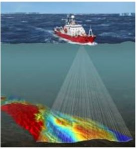
Hydrography is the field concerned with measuring and mapping water surfaces, such as rivers, lakes, seas, and oceans. Hydrographers collect data on water depths, the shape of the seabed, and the location of coastlines and waterways. This information is essential for safe navigation, environmental protection, and the planning of maritime infrastructure.

To collect this data, hydrographers use modern technology such as sonar equipment, GPS systems, and unmanned vessels. The measurements are often combined with geodata and geospatial information to create accurate maps and 3D models of the underwater world.

The applications are diverse. For example, hydrographic surveys play a key role in the construction of offshore wind farms, port management, and the monitoring of coastal changes. Due to climate change and rising sea levels, reliable and up-to-date hydrographic data is becoming increasingly important.

In short, hydrography is indispensable for anyone working with water, technology, and geospatial insights.

What will you learn in this Blended Learning course?

In this basic hydrography course, you’ll discover how accurate measurements provide insight into our waterways and maritime environment. You’ll learn step by step how to use modern equipment, such as echo sounders, multibeam systems, and GPS, and how these technologies are applied in situations like coastal management, waterway management, and environmental monitoring.

The program combines theory with practice. You will not only gain a solid foundation in the technical operation of hydrographic measuring instruments, but also learn how to collect, analyze, and convert measurement data into actionable insights. You will apply this knowledge in realistic scenarios such as port development, river management, and monitoring coastal changes.

In addition, you’ll gain experience processing geodata and geospatial information, which will teach you how to accurately map underwater areas. The lessons are structured around relatable real-world examples and interactive assignments, so you can immediately see how hydrography works in the real world. Through the combination of technical content and practical application, you’ll develop a keen understanding of the field and learn how, as a future hydrographer, you can contribute to sustainable and efficient solutions in the water sector.

Why choose this Basic Hydrography course?

Blended learning combines independent online learning with practical, interactive sessions. This allows you to gain both theoretical knowledge and practical experience with hydrographic surveys, data processing, and geospatial analysis. The online modules give you the freedom to learn at your own pace. They include interactive lessons on topics such as sonar principles, water depth measurement, map interpretation, and processing survey data.

You’ll discover how to work with equipment such as echo sounders and multibeam systems, and learn how to analyze measurement data and link it to geodata. This will help you understand how this information is applied in areas such as coastal management and waterway monitoring.

During the hands-on online sessions, you’ll apply your knowledge immediately. You’ll work with realistic hydrographic datasets and receive guidance from experienced specialists. You’ll learn how to perform accurate field measurements, how to process that data correctly, and how to use it to clearly map waterways or seabeds, for example. This will give you a solid understanding of how hydrography is applied in a wide range of projects—from port development to environmental monitoring.

Thanks to the combination of flexible learning and practical assignments, you’ll not only learn to use modern measuring equipment but, more importantly, how to apply that knowledge in real-world situations. After this course, you’ll be able to independently collect, analyze, and use hydrographic data. In a world where reliable geodata is becoming increasingly important, that’s an indispensable skill.

If this introduction has sparked your interest and you’d like to further your career as a hydrographer, our traineeship might be the right fit for you. We’ll guide you through your learning journey and ensure you can get started in the field. This way, you’ll build a future in the world of hydrography step by step.

Enroll

€395,- (VAT included)
  • Start: 2-hour online session
  • Self-study: Review course materials
  • End: 1-hour online session
Register for this course

You’ll receive 1-on-1 guidance. After signing up, our course coordinator will contact you to schedule your first session.

Leerdoelen

After completing this course, you will be able to:

  • Conduct hydrographic surveys using echo sounders and multibeam systems to map water depths and seabeds.
  • Process and analyze measurement data using geospatial software to create reliable maps and models.
  • Combine field measurements with geodata for applications such as waterway management, coastal monitoring, and port development.
  • Use hydrographic datasets to interpret real-world situations and support decision-making in water management.

Want to know more?

Do you have questions about the course content? Or are you unsure whether the course aligns with your learning goals or preferences? Would you prefer an in-house or private course? We’d be happy to help.

Frequently Asked Questions About Courses

After the course, you’ll have another two weeks to ask the instructor questions. Since the instructor is already teaching other courses, it’s best to email your questions to info@geo-ict.nl. Your question will be forwarded to the instructor, and you’ll receive a response within 24 hours.

If you’re a bit further along and encounter practical problems you can’t solve on your own, it’s best to use Online Support. You’ll spend one day online with the instructor and receive personalized one-on-one instruction. All your problems will be resolved, and you’ll have made significant progress.

  • Blended learning, also known as hybrid learning, is an educational method that combines traditional face-to-face classes with online learning materials and interactive sessions. This approach offers students flexibility and control over aspects such as the time, place, and pace of learning, while allowing them to benefit from direct interaction with instructors and fellow students. ​
  • At the Geo-ICT Training Center in the Netherlands, blended learning is implemented by having students study largely independently, supplemented by scheduled interactive sessions with an instructor. During these sessions, students can ask questions and discuss complex topics, which fosters a deeper understanding of the course material. All Blended Learning courses begin with a 2-hour online session. The instructor delivers presentations and assigns various exercises and assignments to the student. The student can then work on these independently. After a few weeks, another one-hour online session follows.

If you run into problems in practice that you can’t solve on your own, you have two options: you can sign up for a beginner or advanced course, or you can sign up for Online Support.

You’ll spend a day online with an instructor and receive personalized one-on-one instruction. All your problems will be resolved, and you’ll have made significant progress.


All courses are taught in person. Course hours are from 9:00 AM to 4:00 PM. Coffee, tea, lunch, and a laptop are provided.

Taking a course online is also possible, but we only offer hybrid courses in exceptional cases. If you wish to participate in a course online, please indicate this during registration—select “Online” as the location. If that is not possible, this course will only be offered on-site in Apeldoorn.

Yes, we do this regularly. Our instructor will come to your location and bring laptops for the participants. All you need to do is arrange a classroom at your location.

Please email your requirements to info@geo-ict.nl, and we will send you a quote. Once you’ve confirmed the order, our course coordinator will contact you to schedule the training days.

After each course, participants receive a link to our evaluation portal. There, you can share your feedback on what you liked and didn’t like about the course. We always do our very best, but of course, there may be times when you have a complaint. Click on “Complaints Procedure.” It explains what steps you can take. Geo-ICT Training Center, Netherlands is a member of the Dutch Council for Training and Education (NRTO).

After the course, we will email you a link to our evaluation portal. There, you can log in and fill out an evaluation form, and you can also download your certificate of participation.

Â