During this three-day course, you—as a secondary school teacher—will learn how to effectively introduce and apply GIS (Geographic Information Systems) in secondary education. You will be introduced to various tools, ranging from user-friendly applications to professional software, and develop lesson plans that can be put to immediate use.
Course duration: 3 days
Nederlands
Warning: Undefined array key 0 in /var/www/html/wp-content/themes/treesign/templates/parts/content/courses/single/content.php on line 6
Introduction to GIS in Secondary Education
In today’s education, increasing emphasis is placed on developing digital skills and working with real-world data. Geographic Information Systems (GIS) provide an excellent platform for this. GIS technology enables students to investigate spatial issues, collect and analyze data, and visually present their findings.
These skills are not only valuable in geography education but also relevant to subjects such as biology, social studies, history, and even mathematics. However, many teachers are unfamiliar with the possibilities GIS offers or find the barrier to getting started too high. This course has been specifically designed to break down this barrier. You will learn step by step how to work with various GIS tools, from simple applications like Google My Maps to more advanced software such as QGIS and ArcGIS Online.
The focus is always on direct applicability in educational practice. Through practical examples, hands-on exercises, and educational projects, you will develop the confidence and skills to integrate GIS into your lessons. You will discover how GIS can help stimulate inquiry-based learning, promote spatial understanding, and spark students’ enthusiasm for geographic and social issues. Upon completion of this course, you will be able to guide your students in using GIS as a powerful tool for exploring and understanding the world around them.
What is GIS in an educational context?
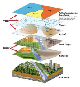
Geographic Information Systems (GIS) in education bridge the gap between theoretical concepts and the real world. GIS is more than just a technology for creating maps; it is a set of tools that enables students to ask spatial questions, collect and analyze geographic data, and draw well-founded conclusions.
In an educational context, GIS can be defined as:
A research tool that allows students to discover and analyze spatial patterns.
A visualization tool that makes complex geographic information accessible and understandable.
A platform for integrating various disciplines and themes, from climate change to demographic trends.
A skills developer that fosters critical thinking, digital literacy, and problem-solving abilities. GIS in education can take various forms, ranging from simple web-based applications to more advanced desktop software.
In this course, we explore a range of tools:
Accessible GIS tools such as Google My Maps are ideal for an introduction and for younger students. They require little technical knowledge but still offer valuable opportunities for spatial analysis.
Web GIS platforms such as ArcGIS Online combine ease of use with powerful functionalities, making them suitable for a wide range of educational levels.
Professional GIS software such as QGIS offers extensive analysis capabilities and prepares students for using GIS in further studies and professional contexts. By becoming familiar with this spectrum of GIS tools, you as a teacher can choose the most suitable approach for your specific educational context, learning objectives, and the level of your students.
Note: This course is intended for teachers working in secondary education. Check out the GIS course for a more general approach to GIS!
Benefits of GIS in Secondary Education
The integration of GIS in secondary education offers numerous benefits that contribute to both students’ cognitive development and motivation. Below are some of the key benefits:
Stimulates inquiry-based and discovery-based learning: GIS encourages students to ask questions, collect and analyze data, and look for patterns and connections on their own. This active learning process promotes deep understanding and critical thinking.
Enhances spatial awareness: By working with maps and spatial data, students develop a better understanding of geographic concepts and spatial relationships—a skill that is valuable in many fields and professions.
Updates the curriculum: GIS enables teachers to integrate current topics and recent data into their lessons, making education more relevant and meaningful for students.
Develops 21st-century skills: Working with GIS promotes digital literacy, data analysis skills, problem-solving abilities, and collaboration—all essential skills for the future.
Interdisciplinary applications: GIS can be applied across various disciplines, from geography and biology to history and social studies, facilitating interdisciplinary learning and project-based education.
Prepares for higher education and careers: GIS skills are increasingly in demand in higher education and the job market, from urban planning and environmental management to logistics and marketing. By integrating GIS into your teaching, you not only provide students with a valuable tool for understanding the world around them, but also equip them with practical skills that expand their future opportunities. GIS makes abstract geographic concepts concrete and tangible, leading to a deeper understanding and greater engagement with the subject matter among students.
What You’ll Learn in the GIS in Secondary Education Course
This three-day course offers a comprehensive overview of GIS applications specifically tailored to secondary education. From simple introductory applications to more advanced projects, you will develop a toolkit of GIS skills and lesson ideas that can be immediately implemented in your teaching practice.
Accessible GIS Applications
The first step toward successful GIS integration in education is mastering accessible tools that require little technical knowledge yet offer powerful learning opportunities:
Google My Maps: You’ll learn how to use this intuitive tool to create interactive maps, add different layers of information, and perform simple spatial analyses.
Zoo Assignment: You’ll engage in a hands-on learning activity where students map animal habitats, visualizing concepts such as habitat, adaptation, and ecosystems.
Basic Theory: You’ll gain insight into fundamental geographic concepts such as coordinate systems, GPS, and map projections, and how to convey these to your students in an understandable way. These accessible applications provide an excellent starting point for both you and your students to become familiar with GIS principles without being overwhelmed by technical complexity.
Working with GIS software
After covering the basic applications, you’ll be introduced to more advanced GIS tools that offer more extensive analysis capabilities:
QGIS and ArcGIS Online: You’ll learn the basics of these widely used GIS platforms, including importing data, creating thematic maps, and performing spatial analyses.
Survey123: You’ll discover how to use this tool to collect field data via smartphones or tablets, actively engaging students in data collection outside the classroom.
Practical Applications: Through targeted exercises, you will develop skills in creating heat maps, buffer analyses, and other GIS techniques relevant to education. These skills will enable you to integrate GIS more deeply into your lessons, allowing students not only to consume information but also to actively perform geographic analyses.
Project-based work with geofiction
One of the most engaging ways to apply GIS in education is through geofiction projects, in which students combine their creativity with geographic principles:
Utopia Project: You’ll learn how to set up an interdisciplinary project in which students design a fictional island, taking into account geographical, ecological, and social factors.
Integration of art and science: You’ll discover how hand-drawn maps can be combined with digital GIS data, bridging the gap between creative and analytical skills.
Dutch open data: You’ll be introduced to sources such as PDOK and EduGIS, and learn how to integrate this open geodata into your educational projects. This project-based approach encourages students to apply geographic concepts in a creative context, leading to a deeper understanding and greater engagement in the learning process.
Why choose our GIS Application in Secondary Education Course?
Our GIS Application in Secondary Education Course at Geo-ICT Training Center stands out thanks to a unique combination of technical expertise, pedagogical insights, and direct practical applicability. Here are a few reasons why this course is a valuable investment in your professional development:
Specifically tailored to secondary education: Unlike generic GIS courses, this training has been specially developed for the educational context, with a focus on curriculum requirements, learning objectives, and the students’ perspective.
Step-by-step structure: The course begins with accessible applications and gradually builds toward more advanced concepts, ensuring you feel comfortable at every step of your GIS learning journey.
Ready-to-use teaching materials: You’ll leave the course not only with knowledge and skills, but also with concrete teaching materials, assignments, and projects that you can immediately implement in your own teaching practice.
Balance between theory and practice: The course combines essential theoretical knowledge with extensive hands-on experience, enabling you to understand both the “why” and the “how” of GIS in education.
Access to expertise: You benefit from the combined knowledge of experienced GIS professionals and education experts, who not only teach you technical skills but also provide insight into effective pedagogical implementation. By choosing this course, you are not only investing in your own professional development but also contributing to enriching the educational offerings for your students. You will empower them to approach geographic issues using modern tools and methods that enhance their analytical skills, spatial awareness, and digital literacy. Join a growing community of education professionals who integrate GIS into their teaching practice and discover how this technology can help create a richer, more engaging learning environment. We look forward to welcoming you to the Geo-ICT Training Center and exploring the possibilities of GIS in secondary education together.
Integrating GIS into Educational Practice: Learning strategies for effectively implementing GIS in the curriculum, with a focus on promoting digital literacy and critical thinking among students.
Understanding GIS concepts: Gaining insight into the basic principles of Geographic Information Systems (GIS) and their application in education.
Using GIS tools: Learning to work with various GIS tools, ranging from accessible applications such as Google My Maps to professional software such as QGIS and ArcGIS Online.
Developing teaching materials: Creating immediately applicable lesson projects and assignments that integrate GIS into various subjects within secondary education.
Analyzing spatial data: Developing skills to collect, analyze, and visually present geographic data to support inquiry-based learning.
Warning: Undefined array key 0 in /var/www/html/wp-content/themes/treesign/templates/parts/content/courses/single/info.php on line 1
Want to know more?
Do you have questions about the course content? Or are you unsure whether the course aligns with your learning goals or preferences? Would you prefer an in-house or private course? We’d be happy to help.
Frequently Asked Questions About GIS in Secondary Education
GIS promotes active and inquiry-based learning. Students work with real-world data, analyze spatial patterns, and develop skills such as critical thinking, problem-solving, and data literacy. GIS integrates seamlessly with subjects such as geography, biology, history, and social studies, and prepares students for the digital age.
A computer with an internet connection is often all you need. Many GIS tools are free or come with an educational license (such as ArcGIS Online). It’s also important for teachers to develop some basic skills—for example, by taking a short course—so they can guide their students. Teaching materials, datasets, and manuals are widely available online.
Not necessarily. There are user-friendly tools like Google Earth or ArcGIS Online that are suitable for beginners. As students become more proficient, they can transition to more advanced software like QGIS. Differentiation is possible: students can work with GIS at their own level, from creating maps to performing spatial analyses.
GIS can be flexibly integrated to supplement existing lesson plans. For example: have students visualize population density in demography classes, or analyze water management in sustainability classes. Ready-to-use GIS lesson modules are available that align with curriculum learning objectives, such as the exam material for geography.
Request a quote
Search the website
Find courses, MOOC content, articles and more in one place.