
Remote sensing is the collection of data on phenomena in the atmosphere, on the Earth's surface, and below the Earth's surface through measurements taken by satellites and aerial platforms.
Drones and Satellites
Remote sensing is the collection of data on phenomena in the atmosphere, on the Earth's surface, and below the Earth's surface through measurements taken by satellites and aerial platforms.
 Remote sensing is a rapidly evolving field of technology. It offers us a unique opportunity to observe and understand our planet from a perspective that was previously unattainable. At its core, remote sensing is the process of collecting information about an object or area without making physical contact, often from the air or space. This technology uses various satellites and aerial platforms to gather essential data about our Earth—ranging from atmospheric conditions to the health of our vegetation and the dynamics of our urban areas.
At Geo-ICT, we understand the power and potential of this technology and offer a Remote Sensing Course that not only provides in-depth knowledge and understanding of the science behind remote sensing but also equips participants with practical skills in using leading software such as Erdas. This course is designed to equip participants with the skills to understand and apply multispectral remote sensing, aerial photography, photogrammetry, and image interpretation, as well as the knowledge to use advanced image analysis tools for a wide range of applications.
The value of remote sensing extends across many sectors, from environmental science and urban planning to agriculture and forestry. The ability to monitor and analyze large geographic areas with unprecedented speed and accuracy makes it an indispensable tool for professionals working with geoinformation and geodata. The course at Geo-ICT is specifically designed to bridge the gap between theoretical knowledge and practical application, so that participants not only learn about the principles of remote sensing but also how to apply this knowledge in real-world scenarios.
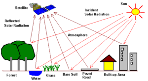
Behind the fascinating world of remote sensing lies a complex science and a wide range of advanced technologies. It enables the collection of data about the Earth from space or the air without direct contact. This involves the use of various sensors on satellites and aircraft. These are capable of collecting different types of data, depending on the technologies used.
At the heart of remote sensing is the interaction between electromagnetic radiation and the surfaces it strikes. This process is central to collecting data about the Earth’s surface, the atmosphere, oceans, and more. The technologies and methods used in remote sensing are diverse and constantly evolving, including:
The application of these technologies has led to significant advances in how we collect and analyze information about our planet. Through the use of software such as Erdas, professionals in geoinformatics can interpret this data and convert it into actionable insights. This opens the door to unprecedented possibilities for research, environmental management, agriculture, and much more.
Remote sensing has emerged as a key technology for a wide range of applications that are crucial to our modern society. The ability to collect data about our planet from the air or space has opened up revolutionary possibilities across various fields. Geo-information and geodata collected via remote sensing are used to gain insight into and provide solutions for some of the most urgent challenges facing our world. Some prominent application areas include:
The course at Geo-ICT offers in-depth insight into how this data can be collected, analyzed, and applied in various scenarios. Through a combination of theory and practice, you will first learn about the science and technology behind remote sensing. And second, you will also learn how to apply this knowledge to solve real-world problems.
Remote sensing is an advanced process that enables us to collect and interpret data about the Earth from a distance. This process is fundamental to understanding the complexity of our planet and plays a crucial role in a wide range of applications. The remote sensing process involves several crucial steps, each with its own important function:
These steps mark the journey from raw data to valuable insights that can help address some of the most critical challenges facing our world. Geoinformation and geodata, obtained through remote sensing, are essential for scientific research, environmental management, and many other applications that require a deep understanding of our world.
In the world of remote sensing, specialized software plays a crucial role in processing and analyzing the collected data. Erdas Imagine is recognized as one of the leading software packages in this field and offers extensive capabilities for image analysis and interpretation of geoinformation. The capabilities of such software are essential for the successful application of remote sensing across various domains. Some key functions and technologies used in this process include:
Erdas Imagine integrates these and many other technologies into a single powerful platform, giving users access to a wide range of tools for geoinformation analysis. This includes:
Through these technologies and software, such as Erdas Imagine, professionals are able to convert the vast amounts of data collected by remote sensing into actionable insights. These insights play a key role in addressing challenges in environmental science, agriculture, urban planning, and many other sectors.
Choosing a remote sensing course at Geo-ICT is a step toward a future where you will not only have a deep understanding of this crucial technology but also the skills to apply this knowledge in practice. At Geo-ICT, we stand out thanks to a unique combination of factors that make our program not only educationally valuable but also highly relevant to today’s and tomorrow’s job market. Here are a few reasons why our course is the right choice for you:
By choosing our course, you’re investing not only in your educational development but also in your future career. The combination of our experienced instructors, hands-on approach, and focus on the application of geoinformation and geodata across various sectors makes our course unique. At Geo-ICT, you’re not just learning. You’re preparing to play a leading role in the future of remote sensing and geoinformation technology.

Do you have questions about the course content? Or are you unsure whether the course aligns with your learning goals or preferences? Would you prefer an in-house or private course? We’d be happy to help.
Remote sensing, or Earth observation, is the process of collecting data about the Earth from the air or space, for example via satellites. This technique is used for environmental research, agriculture, and urban planning.
This course is ideal for entry-level geoscientists, experienced geoscientists, companies in the geospatial sector, career changers, and educational institutions looking to expand or refresh their knowledge of remote sensing.
We primarily use Erdas software and various image analysis tools. These are essential for processing and interpreting remote sensing data.
The course covers a wide range of topics, including the remote sensing process, aerial photography, photogrammetry, multispectral remote sensing, laser altimetry, thermal infrared, gamma spectroscopy, radar and satellites, and visual and automated image interpretation.
The course lasts 3 days. The first day includes an introduction to remote sensing, its history and principles, the relationship between remote sensing and other spatial technologies, the principles of photogrammetry, and information about data sources for satellite imagery.
The course aims to develop a thorough understanding of the entire remote sensing process, knowledge of various remote sensing technologies, skills in image analysis and interpretation, insight into the remote sensing chain, and the application of remote sensing in real-world scenarios.
Yes, after the course, you can continue to ask the instructor questions via email for another two weeks.
The course is offered both in person and online. The course runs from 9:00 a.m. to 4:00 p.m. Coffee, tea, lunch, and a laptop are provided for in-person participants.
Yes, it is possible to hold the course on-site. Our instructor will come to your location with the necessary laptops. Please contact us to discuss the options.
After each course, participants will receive a link to our evaluation portal where they can provide feedback and download their certificate of completion.