Job Opening: Measurement Technician

In the coming years, major construction and infrastructure projects will be carried out in the Netherlands. This requires many quantity surveyors. A project stands or falls on accurate measurements. Do you have a technical vocational or higher vocational education background, an eye for detail, and a desire to work on construction and infrastructure projects? As a quantity surveyor, you’ll have the opportunity to develop your skills in the world of geodata and quantity surveying. This traineeship is the perfect way to become a professional in the construction and infrastructure sector—even without prior experience!

Does this sound like something for you? Read on and discover how you can get started as a Junior Surveyor!

  • An immediate one-year contract with the prospect of permanent employment
  • Salary starting at €2,500 gross per month from day one
  • Fully paid traineeship: you’ll be trained as a quantity surveyor without needing any prior experience
  • Gain work experience at leading companies in the construction and infrastructure sectors.
  • A company car so you can easily travel to project sites.
  • Learning to work with modern software and equipment, such as GPS systems, total stations, laser scanners, and digital levels
  • Nationwide opportunities – projects throughout the Netherlands

About the Job Opening: Foreman

Een maatvoerder gebruikt een Topcon FC-5000 tablet om metingen te verrichten op een bouwplaats. De robuuste tablet is bevestigd aan een meetinstrument en toont een digitale bouwtekening. Op de achtergrond zijn stalen wapeningsnetten en rode meetlijnen zichtbaar.
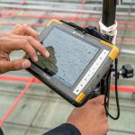
As a quantity surveyor, you will use advanced measuring equipment and software to take measurements and process data. You will assist experienced quantity surveyors and engineers and contribute to the precise execution of construction and infrastructure projects.

What does your work involve?

  • Taking measurements – You use Total Stations, GPS systems, and 3D laser scanners to accurately map sites and structures.
  • Processing measurement data – You analyze and process data in software such as AutoCAD, GIS, and Revit to optimize project plans.
  • Supporting construction and infrastructure projects – You collaborate with engineers and site supervisors to prepare and verify as-built plans.
  • Quality control and precision – You contribute to the accurate layout of construction projects and verify the measurements.

You will receive intensive guidance from experienced surveyors and IT specialists, so that you can work independently in a short period of time.

A surveyor is holding a detailed map and making notes with a red pen at a construction site. In the background, a colleague wearing a safety vest and helmet is standing with surveying equipment, while a digital measuring device on a tripod is visible.

What do we offer you?

  • A competitive starting salary of €2,500–€3,000 gross per month.
  • Comprehensive in-house training, so no prior experience is required. You will take courses such as the Surveying Course, GPS Basics, and/or a course on working with GIS, such as ArcGIS Basics or QGIS Basics.
  • Opportunities for advancement to Mid-Level/Senior Surveyor, Project Manager, or Specialist.
  • A company car and travel allowance.
  • Excellent benefits, including 25 vacation days and a pension plan.

Are you looking for a stable, well-paying job with plenty of opportunities for growth and learning? Then this is the perfect opportunity!

What do we require from you?

  • At least an MBO or HBO degree in Archaeology, Architecture, Civil Engineering, Mechanical Engineering, Electrical Engineering, or a comparable program.
    Don’t have a degree but are interested in engineering? Then let’s explore the possibilities together!
  • A Class B driver’s license. You’ll be working at various locations, so mobility is important.
  • An affinity for engineering and geometry. You enjoy working with GPS systems, drones, and surveying software.
  • You work with precision, have an analytical mindset, and are eager to learn

Bonus points (not required!):

  • Experience with surveying equipment such as Total Stations or GPS systems.
  • Knowledge of software such as AutoCAD, GIS, or Revit.
  • Interest in geodata and spatial analysis.

Do you recognize yourself in this profile? Then apply right away!

Working at Geo-ICT

Geo-ICT Training Center is a training and staffing partner in the geosector. We train entry-level professionals and experienced professionals and connect them with employers in construction, civil engineering, and infrastructure.

Why choose Geo-ICT?

  • An immediate one-year contract with job security and opportunities for growth.
  • Paid traineeship and personal mentoring.
  • Projects in construction, civil engineering, and infrastructure.
  • Work with the latest technologies, such as AutoCAD, GIS, and 3D laser scanners.
  • A supportive work environment where your development is a priority.

Apply – Here’s how it works!

Are you excited about the Junior Quantity Surveyor position and want to get started right away? Applying is easy and can be done in three steps!

  1. Upload your resume and cover letter | Click the apply button and send us your resume and a brief cover letter.
  2. Introductory interview | We’ll contact you within a few business days to schedule an introductory interview.
  3. Start your traineeship! | Have you been selected? Congratulations! You’ll immediately receive a one-year contract with the possibility of a permanent position, a competitive salary, and personalized guidance.

Tip: Make sure your resume is up-to-date and that your cover letter shows why you’re the ideal candidate!

About Geo ICT Training Center, Netherlands

Geo-ICT Training Center, Netherlands is a leading training institute and staffing agency in the geospatial sector. We specialize in offering various certified courses such as ArcGIS, AutoCAD, and FME Desktop. In addition to courses, we also offer traineeships and study opportunities for entry-level professionals in the geospatial sector. With a wide range of educational programs and training courses, we are committed to training the next generation of geospatial information specialists.

My name is Maikel van der Wijk. I’m the HR Manager. Would you like more information?

Frequently Asked Questions About the Site Foreman Position

As a Survey Technician, you are responsible for staking out and surveying construction and infrastructure projects. This means using surveying instruments (such as GPS, total stations, and 3D laser scanners) to precisely determine and verify locations and construction points. You then input the survey data into software (CAD/GIS) to ensure that construction and implementation proceed correctly.

Without precise measurements, no construction or infrastructure project can be carried out correctly and safely. Your work ensures that foundations, walls, pipes, and other structural components are placed exactly where they belong. This prevents errors, delays, and extra costs.

At Geo-ICT, you’ll work not only with traditional surveying methods, but also with modern geoinformatics and digital surveying equipment. You’ll receive training and guidance—even if you have no prior experience—and learn to work with tools such as GPS, total stations, laser scanners, and CAD/GIS software.

As a Site Foreman, you can work on a wide variety of projects: from residential and commercial construction to infrastructure, road, and civil engineering projects. Exactly what you’ll be working on depends in part on your interests and which client you’re assigned to.

A technical vocational or higher vocational education degree is preferred. Additionally, attention to detail, spatial awareness, a keen eye for detail, a willingness to work in the field, and an interest in geoinformation are important. Experience with surveying equipment or CAD/GIS is a plus, but not required—Geo-ICT provides in-house training.

No—you can start even without experience. Geo-ICT offers a traineeship that includes training and guidance to help you become a fully qualified quantity surveyor.

You’ll start with a one-year contract, with the possibility of a permanent position. Salary starts at approximately €2,500 gross per month. You’ll receive training in measurement methods, software, and geoinformation, gain experience working with various clients, and often be provided with a company car due to work at different locations.

You often start on-site: setting up measuring equipment, establishing reference points, and staking out or surveying sites or building components. Later, you process the measurement data in CAD or GIS software and verify that the results match the design and plans. You then coordinate with the project team on next steps.

You can advance to roles such as Senior Quantity Surveyor, Civil Engineering Planner, Land Surveyor, or specialist in geodata/surveying tasks, depending on your interests and career development.

You can apply directly through this job posting by filling out your details and cover letter and uploading your resume; this is usually followed by an introductory interview. If you’re unsure whether your profile is a good fit, you can also contact us for more information with no obligation.