Job Opening: Surveyor

Are you looking for a job that combines indoor and outdoor work? Do you have a technical vocational or higher vocational education degree and want to change careers? Then this land surveyor position is perfect for you! As a Junior Land Surveyor, you’ll learn how to survey sites, stake out property boundaries, and conduct land surveys for the BAG and BGT Basic Registries. You’ll work with the latest surveying equipment, such as Total Stations, GPS receivers, and drones. You’ll also process the measurements using CAD, GIS, and Pix4D software.

Does this sound like the right fit for you? Read on and discover how you can get started as a Junior Surveyor!

  • An immediate one-year contract with the prospect of permanent employment
  • Salary starting at €2,500 gross per month from day one
  • Fully paid traineeship: you’ll be trained as a land surveyor without needing any prior experience
  • Gain work experience at leading organizations such as municipalities, water boards, the Land Registry, and surveying firms
  • A company car so you can easily travel to project sites.
  • Learn how to use modern surveying software and equipment, such as GPS systems, AutoCAD, and GIS software.
  • Nationwide opportunities – projects throughout the Netherlands

About the role of a surveyor

Een landmeter met een witte helm en een gele veiligheidshes voert metingen uit op een open veld. Ze houdt een controller vast en werkt met een Topcon total station, dat op een statief staat opgesteld in de achtergrond.
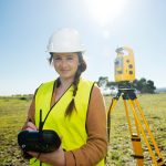
As a surveyor, you’ll have a unique opportunity to learn a technical trade even without prior experience. You’ll be trained to become a professional who uses high-tech surveying equipment and software to map the world around you.

What does your job entail?

  • Surveying sites: You will accurately map parcels, buildings, topography, boundaries, cables, and pipelines
  • Equipment: You’ll work with advanced instruments such as Total Stations, Scanners, GPS receivers, and Drones.
  • Staking out building lines: You determine exactly where roads, buildings, and bridges will be located.
  • Data processing: Using CAD and GIS software, you analyze measurement data and create usable maps
  • Collaborating with project teams: You will work alongside contractors, engineers, and architects.

You’ll receive intensive guidance from experienced surveyors, so that you can quickly learn to conduct measurements and process data independently.

A surveyor is wearing a yellow hard hat and a black jacket while using a surveying instrument on a construction site. In the background, construction workers are working in hard hats and work clothes.

What do we offer you?

  • A competitive starting salary of €2,500–€3,000 gross per month.
  • Comprehensive in-house training, so no prior experience is required. You will take courses such as the surveying program, GPS basics, and/or a course on working with GIS, such as ArcGIS Basics or QGIS Basics
  • Opportunities for advancement to roles such as Mid-Level Surveyor or Geodesy Project Manager.
  • A company car and travel allowance.
  • Excellent benefits, including 25 vacation days and a pension plan.

Are you looking for a stable, well-paying job with plenty of opportunities for growth and learning? Then this is the perfect opportunity!

What do we require from you?

  • At least an MBO or HBO degree in Archaeology, Architecture, Civil Engineering, Mechanical Engineering, Electrical Engineering, or a comparable program. Don’t have a degree but are interested in engineering? Then let’s explore the possibilities together!
  • An affinity for technology and geometry. You enjoy working with GPS systems, drones, and surveying software.
  • A Class B driver’s license. You’ll be working at various locations, so mobility is important.
  • A meticulous and self-reliant work ethic. 

Bonus points (not required!):

  • Experience with AutoCAD, GIS software, or other drafting programs.
  • Experience with 3D scanners or drones.
  • Experience with a Total Station or GPS.

Do you see yourself in this profile? Apply now!

Working at Geo-ICT as a surveyor

Geo-ICT Training Center is a training and staffing partner in the geosector. We train entry-level professionals and experienced professionals and connect them with employers in surveying, construction, civil engineering, and GIS.

Why choose a traineeship at Geo-ICT?

  • An immediate one-year contract with job security and opportunities for growth.
  • Traineeship and personal guidance; start without experience.
  • Projects throughout the Netherlands, with municipalities, the Land Registry, water boards, and surveying firms.
  • Work with the latest technologies, such as AutoCAD, GPS systems, and GIS.
  • A supportive work environment where your development is a priority.

Apply – Here’s how it works!

Are you excited about the Junior Surveyor position and want to get started right away? Applying is easy and can be done in three steps!

  1. Upload your resume and cover letter | Click the apply button and send us your resume and a brief cover letter.
  2. Introductory interview | We’ll contact you within a few business days to schedule an introductory interview.
  3. Start your traineeship! | Have you been selected? Congratulations! You’ll immediately receive a one-year contract with the possibility of a permanent position, a competitive salary, and personalized guidance.

Tip: Make sure your resume is up-to-date and that your cover letter shows why you’re the ideal candidate!

About Geo ICT Training Center, Netherlands

Geo-ICT Training Center, Netherlands is a leading training institute and staffing agency in the geospatial sector. We specialize in offering various certified courses such as ArcGIS, AutoCAD, and FME Desktop. In addition to courses, we also offer traineeships and study opportunities for entry-level professionals in the geospatial sector. With a wide range of educational programs and training courses, we are committed to training the next generation of geospatial information specialists.

My name is Maikel van der Wijk. I’m the HR Manager. Would you like more information?

Frequently Asked Questions About the Surveyor Job Opening

As a surveyor, you measure land, buildings, and infrastructure, and accurately determine distances, boundaries, angles, and elevation differences. You map topography, perform cadastral surveys, and process all data into drawings, floor plans, or digital maps using CAD or GIS software.

Precise surveying is the foundation of reliable construction, infrastructure, and land-use projects. Without your measurements, property boundaries, land locations, or infrastructure designs could be inaccurate, which could lead to errors, delays, and legal uncertainty.

You’ll start as a junior surveyor with no prior experience on a fully paid training program: you’ll learn to work with modern surveying equipment (total stations, GPS, drones) and software for CAD, GIS, and data processing. This will enable you to become a fully qualified surveyor.

You may be assigned to land and site surveys, cadastral projects, work related to basic registries (such as BAG and BGT), road and infrastructure projects, or construction projects. The specific nature of your work will depend in part on your interests and the client you are assigned to.

A vocational or higher vocational education degree in engineering, civil engineering, geodesy, or a related field is preferred. In addition, a practical interest in engineering/geometry, attention to detail, spatial awareness, the ability to work independently, and a Class B driver’s license are important. Experience is not required; on-the-job training is provided.

No—you can apply even without experience. Geo-ICT offers a traineeship/training program where you’ll learn all the necessary knowledge and skills to perform surveying work independently.

You will start with a one-year contract with the possibility of a permanent position. The salary starts at approximately €2,500 gross per month. You will receive training in surveying, working with surveying equipment and software, interact with various clients, and travel to different project sites (company car provided).

This position is ideal for candidates who enjoy working outdoors, have a technical aptitude, are detail-oriented, and are interested in geoinformation or surveying. A vocational or college degree in engineering, civil engineering, geodesy, or a related field is a good fit, but motivated entry-level candidates without experience are also welcome to apply, thanks to our in-house training and mentoring.

You’ll often start on-site: setting up surveying equipment (total stations, GPS, drones), conducting site surveys, or determining property boundaries. You’ll then process the survey data in CAD or GIS software, create maps or models, and coordinate with colleagues or clients on next steps.

After your initial period, you can advance to become a mid-level or senior surveyor, a specialist in geodata or 3D surveying, or take on roles with greater responsibility, such as geodesy project manager or inspector.

You can apply directly through this job posting by filling out your details and cover letter and uploading your resume; this is usually followed by an introductory interview. If you’re unsure whether your profile is a good fit, you can also contact us for more information with no obligation.