
The course teaches participants how to use the GeoLinQ data management software platform to collect, process, and utilize spatial data, thereby enabling them to easily configure their own GIS applications.
Data Analysis
The course teaches participants how to use the GeoLinQ data management software platform to collect, process, and utilize spatial data, thereby enabling them to easily configure their own GIS applications.
In the fascinating world of geoinformation and data management, Geographic Information Systems (GIS) play a central role. They are the powerhouses that enable us not only to understand our world but also to shape it in innovative ways. A GIS integrates hardware, software, and data to capture, manage, analyze, and display all types of geographic information. These systems make it possible to visualize spatial and geographic data, analyze issues, and uncover complex patterns and relationships.
GeoLinQ embodies these capabilities and enables professionals to manage data with unmatched precision and efficiency. The platform goes beyond traditional GIS applications by offering a flexible, user-friendly environment for configuring GIS applications, managing data, and performing advanced spatial analyses. This makes GeoLinQ not just a tool but an essential ally in the exploration and management of geodata.
With a focus on practical exercises and core concepts of GeoLinQ, the Geo-ICT course prepares professionals for the challenges of tomorrow. We equip participants with the knowledge and skills to effectively manage and analyze spatial data. The course covers the fundamental principles of GIS, such as data management, importing and exporting data, and configuring GIS applications. This prepares participants to work as data managers or professional surveyors.
The use of GeoLinQ as a data management software platform underscores the continuous evolution of GIS technologies and their growing importance across a wide range of sectors. From urban planning and environmental management to surveying and utility management, GIS enables us to understand the complexity of our physical world and provide solutions that benefit our society.
In our increasingly data-driven world, spatial data serves as a fundamental building block that helps us understand our physical environment. This data, often referred to as geodata, encompasses information tied to a specific location on Earth. This allows us to gain unique insights into various issues, ranging from urban planning to environmental management. But what makes spatial data so essential and unique?
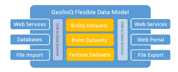
GeoLinQ plays a crucial role in managing and analyzing this spatial data. The platform offers advanced tools for collecting, integrating, managing, and visualizing geodata. This allows users to unlock powerful insights and optimize their workflows. Whether it involves importing and exporting datasets, configuring GIS applications, or performing spatial analyses, GeoLinQ is central to the management of geographic information.
The GeoLinQ course at Geo-ICT delves deep into the world of spatial data, offers participants the opportunity to gain hands-on experience with this powerful platform, and prepares them to tackle the challenges of managing complex geographic datasets.
In the age of digitization and data abundance, Geographic Information Systems (GIS) play a crucial role in modern data management strategies. GIS’s ability to collect, analyze, and visualize spatial data makes it an indispensable tool for a wide range of applications and industries. From urban planning and environmental management to logistics and emergency response, GIS provides the insights needed to make location-based decisions. But how exactly does GIS contribute to modern data management?
GeoLinQ is at the forefront of these developments by offering a platform that is not only robust and versatile but also user-friendly. It enables users to perform complex data management tasks—from managing data sources and datasets to configuring GIS applications and performing advanced spatial analyses. All of this contributes to the mission of making spatial data more accessible and usable for professionals in various fields.
By participating in the GeoLinQ course at Geo-ICT, you’ll have the opportunity to gain in-depth knowledge of GIS principles and learn how to apply this powerful technology in your own work.
Diving into the core concepts of GeoLinQ reveals a fascinating world of possibilities for anyone interested in working with geoinformation and data management. GeoLinQ is known for its flexible and user-friendly platform that enables professionals to manage spatial data efficiently and effectively. But what exactly are the fundamental principles that make GeoLinQ so powerful and distinctive?
From configuring GIS applications to managing data sources and datasets, the course offers a thorough introduction to all aspects of GeoLinQ. Participants will not only learn about the theoretical foundations of the platform but will also have the opportunity to gain practical experience through a series of hands-on exercises.
This hands-on approach ensures that participants leave not only with a deep understanding of GeoLinQ’s core concepts, but also with the skills and confidence to apply this knowledge in their own projects and work.
A key part of learning to work with GeoLinQ and understanding geoinformation involves the practical exercises and applications. This hands-on approach brings the theory to life and gives participants the opportunity to get started with the software right away. The practical exercises are designed to foster a deep understanding of how GeoLinQ can be applied in the real world. But what exactly do these practical exercises entail?
During the GeoLinQ course at Geo-ICT, participants are immersed in a series of practical activities that prepare them for real-world data management challenges:
This hands-on approach ensures that participants not only learn about the capabilities of GeoLinQ but also gain experience using this powerful tool across a range of applications. It enables them to apply the theory they have learned to practical situations. As a result, they develop valuable skills that are immediately applicable in their professional lives.
Choosing the GeoLinQ course at Geo-ICT is a decision that can give your career in the world of geoinformation and data management a huge boost. But what makes our course so unique and valuable for professionals and those interested in this sector? Here are a few reasons that set Geo-ICT apart from other providers:
This combination of up-to-date technological knowledge, expert instruction, practical experience, and flexibility makes the GeoLinQ course at Geo-ICT an essential step for anyone who wants to get seriously involved with geoinformation and data management. By choosing our course, you’re not only investing in your professional development; you’re also taking an important step toward a future full of opportunities in this rapidly growing field.
Module 1: Concepts
This module provides an overview of GeolinQ’s functionality and covers all the GeolinQ concepts necessary to get started with GeolinQ. Topics covered include:
Module 2: Point Clouds and Rasters
This module is designed for data administrators who want to import, model, and integrate point clouds or raster datasets into GeolinQ. Topics include:
Module 3: Features
This module is designed for data managers who want to import, edit, and model feature datasets in GeolinQ. It covers:
Module 4: Distribution
This module is designed for data managers who want to make datasets available to end users via maps and web services. Topics covered include:
After completing this course, participants will be able to continue working with Geolinq in a practical setting, applying the examples and exercises they learned during the course.

Do you have questions about the course content? Or are you unsure whether the course aligns with your learning goals or preferences? Would you prefer an in-house or private course? We’d be happy to help.
GeoLinQ is an advanced data management software platform, ideal for both novice and experienced geospatial professionals looking to develop their skills in GIS applications.
The course covers essential concepts such as GeoLinQ as a Service, managing data sources and datasets, and practical exercises for effective data management.
Yes, Module 2 of the course focuses specifically on point clouds and rasters, including techniques for importing and exporting this data.
GeoLinQ offers comprehensive training in spatial data management, which is essential for professional surveyors and data managers to work efficiently and accurately in the geospatial sector.
Yes, the course includes various practical exercises that help participants apply the theory in realistic scenarios, which is crucial for effective learning and professional application.
The GeolinQ course lasts one day. The day begins with Module 1, which covers the basic concepts of GeolinQ, followed by Module 2, which focuses on point clouds and grids.
The course offers practical exercises in data management processes, the use of GeolinQ for data sources and datasets, and the application of coordinate systems and dataset styling.
After the course, you’ll have two weeks to ask the instructor questions via email.
Yes, the course can be taken either in person or online. If you choose to participate online, you will take the course via Google Meet.
After the course, you will receive a link to an evaluation portal where you can provide feedback and download your certificate of completion. If you have any complaints, please follow the complaint procedure described on the website.