
Did you know that you can create fantastic and highly usable environmental models for BIM using open-source software?
Construction and Civil Engineering
Did you know that you can create fantastic and highly usable environmental models for BIM using open-source software?
Within Building Information Modeling (BIM), environmental modeling plays a crucial role in the successful execution of construction projects. This innovative approach offers you in-depth insight into the interplay between buildings and their surroundings. This is essential for designing sustainable and efficient spaces. Geo-information and geodata are indispensable tools in this regard. They enable you to create a digital representation of the physical world that is rich in detail and precision. By combining techniques from both the geosciences and architecture, you can tackle complex issues surrounding urban development, spatial planning, and sustainability.
Taking a course in environmental modeling for BIM at Geo-ICT is not only an investment in your professional skills but also in the future of construction projects. You’ll learn about the latest software and technologies, such as Revit and Autodesk. Plus, you’ll get the chance to gain hands-on experience with real-world projects.
Whether it involves analyzing 3D environmental design, integrating GIS for BIM, or navigating the complexities of spatial data analysis, this course provides a solid foundation for anyone who wants to minimize the environmental impact of their construction projects and maximize efficiency.
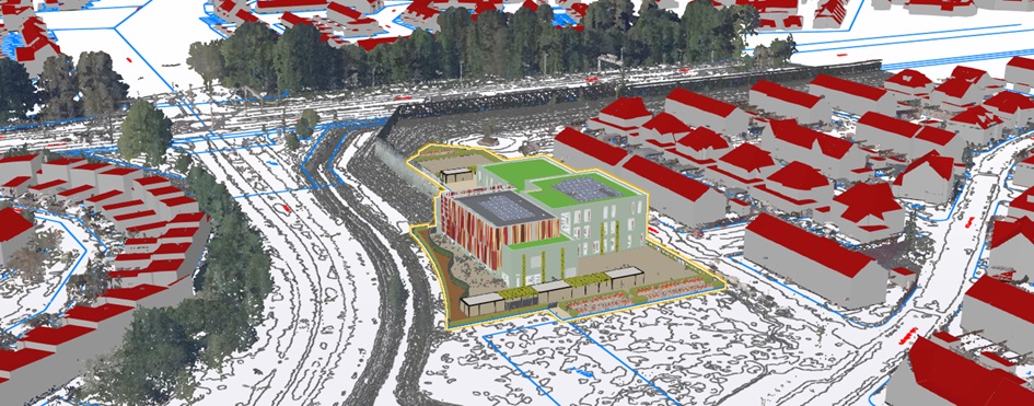
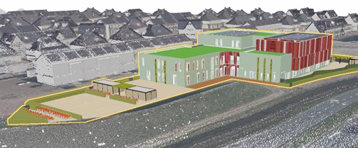
Environmental modeling is an indispensable pillar of Building Information Modeling (BIM). It offers fascinating insights into how our built environment can coexist with the natural world. It goes beyond simply constructing structures. It involves creating a detailed digital twin of our physical world, with geodata and geoinformation at its core. But what makes environmental modeling so essential for professionals in the architecture, engineering, and construction sectors?
By using Revit, Autodesk, and other software, environmental modeling allows you to perform complex analyses, such as sunlight studies, energy consumption analysis, and visualization of future construction projects. These techniques help you, first and foremost, to design aesthetically appealing structures. Additionally, they help ensure that buildings are functional, efficient, and in harmony with the natural environment.
The power of environmental modeling lies in its ability to bridge the gap between the digital and physical worlds. This paves the way for innovative solutions that push the boundaries of traditional construction practices. It is a field that is constantly evolving, driven by technological advancements and the growing need for more sustainable construction methods. By enrolling in an environmental modeling course at Geo-ICT, you’ll equip yourself with the knowledge and skills to be at the forefront of this exciting discipline.
In the world of BIM (Building Information Modeling), open-source software has had a revolutionary impact. This software not only offers cost-effective solutions but also fosters innovation and collaboration within the construction industry. Open-source programs such as FreeCAD, BlenderBIM, and BIMserver enable professionals to perform advanced modeling and analysis tasks without significant investments in licenses. Here are some key points on how open-source software contributes to the BIM sector:
One of the most notable features of open-source software in BIM is IFC compatibility. This ensures interoperability between different software packages. This is crucial for successfully managing BIM projects, where data exchange and integration among various stakeholders are of great importance. By leveraging the power of open-source tools, companies and professionals in the construction sector can work more efficiently and effectively, while keeping costs low and improving the quality of their projects.
The use of open-source software in BIM offers a world of possibilities for professionals involved in environmental modeling. Whether you’re an architect, engineer, or construction manager, the flexibility and accessibility of these tools enable you to push the boundaries of traditional construction techniques and develop innovative, sustainable solutions that contribute to a better built environment.
GeoBIM is an innovative approach that combines the power of GIS and BIM to provide a more holistic view of construction projects. This integration enables professionals to:
Some practical applications of GeoBIM include:
The application of GeoBIM offers significant benefits for the AEC industry:
By taking our Environmental Modeling for BIM course, you’ll gain insight into the theoretical background of GeoBIM and its practical applications. You’ll learn how to use this powerful integration of geodata and BIM to take your projects to the next level, with a focus on sustainability and efficiency.
GeoBIM is an innovative approach that combines the power of GIS and BIM to provide a more holistic view of construction projects. This integration enables professionals to:
Some practical applications of GeoBIM include:
The application of GeoBIM offers significant benefits for the AEC industry:
By taking the Environmental Modeling for BIM course at Geo-ICT, you’ll gain insight not only into the theoretical background of GeoBIM but also into its practical applications. You’ll learn how to use this powerful integration of geodata and BIM to take your projects to the next level, with a focus on sustainability and efficiency.
Choosing the right training program is crucial for your career and development within the world of Building Information Modeling (BIM). Our Environmental Modeling for BIM course at Geo-ICT stands out for several reasons:
Some unique benefits of taking this course include:
By enrolling in our course, you’re taking an important step toward expanding your knowledge and skills in a field that’s becoming increasingly important in the construction and design industry. You’ll be prepared for today’s industry challenges and gain the tools and insights to innovate for the future.
The "Environmental Modeling for BIM Applications" course is a full-day session that helps participants develop practical skills for effective environmental modeling in a BIM context, in addition to covering the theoretical background.
The morning session begins with an introduction to GeoBIM, followed by an overview of the capabilities of QGIS. This covers working with 2D map data, aerial photographs, BGT, and KLIC data. Throughout the course, the emphasis is on gaining hands-on experience through prepared exercises. Processing and classifying laser scan data is also part of the curriculum.
In the afternoon, participants delve deeper into advanced techniques for 3D mesh topography and the use of Trimble Connect as a platform. The day concludes with an interactive Q&A session where questions are discussed and resolved.

Do you have questions about the course content? Or are you unsure whether the course aligns with your learning goals or preferences? Would you prefer an in-house or private course? We’d be happy to help.
The course focuses on creating 3D topography using open-source software, includes hands-on sessions with scan data and Blender, and provides an introduction to GeoBIM.
We use open-source software, with a focus on Blender for 3D modeling and the integration of model data.
The course is designed for anyone interested in environmental modeling with BIM, from beginners to professionals.
It is a one-day course.
The course costs €850, excluding VAT.