
This course focuses on the use of GIS in defense and reconnaissance, teaching you how to apply geographic information for military planning, operations, and intelligence gathering.
Defensie
This course focuses on the use of GIS in defense and reconnaissance, teaching you how to apply geographic information for military planning, operations, and intelligence gathering.
 In the world of defense, situational awareness is of vital importance. GIS (Geographic Information System) offers advanced capabilities for analyzing terrain, geodata, and strategic positions. This enables military units and strategists to make faster, more accurate, and more effective decisions in both peacetime and conflict zones.
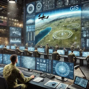
This course focuses on the use of GIS within defense and terrain reconnaissance, teaching you how to utilize geospatial data for military planning, operations, and intelligence gathering. From topographic maps and satellite imagery to advanced 3D terrain models, GIS technology helps create a detailed picture of the environment and contributes to safer and better-informed missions.
In the modern defense sector, GIS (Geographic Information System) plays a crucial role in terrain reconnaissance and strategic planning. Thanks to geodata and geospatial analyses, military units can quickly and accurately map terrain features, risks, and tactical advantages.
Through GIS, defense experts can collect and analyze real-time information, which is essential for military operations, border surveillance, and crisis management. From satellite imagery and aerial photos to detailed digital terrain models—GIS helps translate geographic intelligence into actionable decisions.
In this course, you will learn how GIS is applied in the defense industry and how to optimize terrain reconnaissance using geospatial techniques. Whether you work in military intelligence, operational planning, or strategic decision-making, a thorough understanding of GIS technology is indispensable.
Basic knowledge of GIS systems is not required; we use QGIS during this course. If you’d like to become familiar with that GIS system, check out the QGIS basics course.
This course provides you with in-depth insight into the role of GIS within defense and terrain reconnaissance. You will learn how to apply geospatial technologies to support military operations and how to effectively analyze advanced maps and geodata.
During the course, we will cover topics such as:
Upon completion of this course, you will possess the essential skills to effectively deploy GIS within defense and terrain reconnaissance. You will be able to support strategic decisions with geospatial analyses and will have a solid foundation in GIS tools and techniques.
The use of GIS in defense and terrain reconnaissance is no longer a luxury, but a necessity. Whether you work in the military sector, gather strategic intelligence, or are part of operational units—a solid understanding of geospatial technologies gives you a crucial edge.
This training has been developed for defense analysts, GIS specialists within the armed forces, intelligence officers, and other professionals who want to utilize advanced technology for operational and strategic purposes.
Introduction to GIS in the Defense Sector
Working with GIS data
Terrain reconnaissance with GIS
Practical assignment
GEOINT and spatial analysis
3D terrain models and visualizations
Automation and advanced GIS tools
Application in military operations
Conclusion and certificate presentation

Do you have questions about the course content? Or are you unsure whether the course aligns with your learning goals or preferences? Would you prefer an in-house or private course? We’d be happy to help.
This course is suitable for military personnel, analysts, strategic planners, and anyone involved in defense, reconnaissance, and geospatial intelligence (GEOINT). Professionals in crisis management and border security can also benefit from the course.
No, the course starts with the basics of GIS and gradually builds up to more advanced techniques. Both beginners and participants with some GIS experience can take the course.
The course uses QGIS, a powerful and free GIS software program. It also covers external data sources such as satellite imagery and digital elevation models.
Yes, the course is hands-on. You’ll work with realistic scenarios in which you apply GIS tools to military operations, terrain reconnaissance, and strategic analyses.
Data security is a crucial component of this course, especially given the sensitive nature of military and geospatial information. During the course, data security is addressed in the following ways:
Yes, participants who successfully complete the course will receive a certificate confirming their knowledge and skills in GIS for defense and terrain reconnaissance.
Yes, the course can be held on-site. The instructor will bring laptops, and all you need to do is arrange a classroom.