
Measuring fiber-optic cables.
Measuring fiber-optic cables.
As a surveyor in the world of fiber optic cables, you play a crucial role in the infrastructure that supports our daily lives. It is your responsibility to ensure that fiber optic networks are accurately surveyed and laid out. This requires not only technical knowledge but also a keen eye for detail. Here are some of your daily tasks:
These tasks are essential because errors in this process can lead to serious delays and costs. As a surveyor, you are therefore not only technically skilled but also a vital part of the team that ensures our communication lines are fast and reliable. Your work behind the scenes makes it possible for us to surf the internet, make calls, and exchange data effortlessly.
Working independently and collaborating with various technical teams is part of your daily routine. You’re often on the road, out in the field, where you use modern technology to shape the future of our connectivity.
The work of a fiber optic cable surveyor is crucial to the infrastructure of modern communication networks. Every day, we rely more on fast and reliable internet connections, and your role as a surveyor makes this possible. Here are a few reasons why your job is so important:
In addition, you play a key role in the sustainability of the infrastructure. Through accurate planning and measurements, you help reduce the use of excess materials and minimize the impact on the environment. Your expertise ensures that we, as a society, can operate more efficiently and with greater environmental awareness. Through your work, you connect not only cables, but also people, businesses, and ultimately entire communities.
The role of geoinformation in your work as a fiber optic cable surveyor cannot be underestimated. This data forms the foundation upon which you build your daily work. Geoinformation provides you with the necessary insights to ensure accurate measurements and effective implementation. Here are some specific ways in which geoinformation influences your job:
This information is crucial, not only for accuracy but also for the speed at which projects are completed. With access to up-to-date and detailed maps, you can make decisions faster and avoid unforeseen problems. Moreover, this knowledge makes your work safer and more sustainable by minimizing the risks of damaging existing infrastructure. Geoinformation enables you to bridge the gap between theory and practice, which is essential for the successful installation and maintenance of our ever-growing network of fiber-optic cables.

Do you have questions about the course content? Or are you unsure whether the course aligns with your learning goals or preferences? Would you prefer an in-house or private course? We’d be happy to help.
If you choose a career as a fiber-optic cable surveyor, you’ll start your journey with a certified AutoCAD course through us and complete our comprehensive surveying program. These courses form the foundation of the skills essential to this field.
On-the-job training is a key part of your development. In the first few days, you’ll shadow an experienced surveyor, gaining practical experience that’s crucial for your growth and confidence in the field. You’ll learn not only the ins and outs of surveying and staking out, but also how to process data in CAD and GIS systems.
You’ll start your career at the Geo-ICT Training Center in the Netherlands and be assigned to leading surveying firms such as Ingenieursbureau MUG, Facto-Geo, Leop, Ingenieursbureau RPS, and Kempkes Landmeten. You will start as a junior surveyor, actively involved in processing geometric data. While you study, you will develop into an independent surveyor, a role in which your responsibility and expertise will continue to grow.
As a fiber optic cable surveyor, you play a vital role in the installation and maintenance of fiber optic networks. Your responsibilities are diverse and technically challenging. These include:
Throughout all these tasks, you’ll be in constant contact with the site supervisor, excavation crews, and the engineer. Collaboration and communication are crucial to achieving a successful outcome. Your role ensures that the project runs efficiently and that the network is installed reliably and accurately.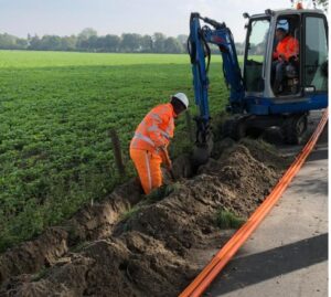
As a Cable and Pipeline Surveyor, you are responsible for surveying and staking out underground cable and pipeline networks. This includes: determining the exact location of existing cables and pipelines on-site using GPS and a total station, staking out routes for new installations, and entering survey data into CAD and GIS systems.
This role is essential because proper cable and pipeline placement prevents damage caused by excavation, delays in construction projects, and unforeseen costs. Through your precise surveying work, you directly contribute to the safety, continuity, and efficiency of infrastructure projects.
Key skills include:
A typical workday might look like this:
Yes, Geo-ICT offers programs that train you for this role so you can start working right away. Check out the Geo-ICT Traineeship job posting. Not sure if this is the right fit for you, but interested in working in the Geo-ICT sector? Then our Geo-ICT Traineeship might be just what you’re looking for!
Career advancement opportunities might include roles such as Senior Surveying Network Engineer, Cable & Pipeline Project Manager, or Geo-Data & Infrastructure Specialist. By gaining additional expertise in the fields of geoinformation technology, pipeline networks, or surveying automation, you can enhance your career prospects.
Although the work is primarily conducted in the field (surveying), knowledge of geoinformation (such as GIS, geodatabases, and location analysis) gives you a clear competitive edge in this role. This enables you to better process, interpret, and integrate survey data into digital systems.
This position is subject to quality standards such as: proper setup and calibration of measuring equipment, accurate recording of cable and pipeline locations, safe working conditions in the field (surface and underground work), and thorough documentation of measurement results and revision drawings. Integration with tunneling systems or KLIC information may also be part of the role.
You can apply directly for the Surveyor (Cables and Pipelines) position or our Geo-ICT Traineeship, or contact us via the widget on our website by entering your name, email address, and phone number to schedule a no-obligation consultation. You can also send us a WhatsApp message. If you have any questions about the job description or whether the position is a good fit for you, please feel free to contact us.