
As a Cadastral Surveyor, you will be responsible for conducting cadastral surveying work and processing the results.
As a Cadastral Surveyor, you will be responsible for conducting cadastral surveying work and processing the results.
As a Cadastral Officer, you are at the heart of the world of geoinformation, where your day is filled with diverse and crucial tasks. What exactly does someone in this role do? Here is an overview:
Your workday as a Cadastral Assistant is thus filled with a mix of technical skills and client interaction, keeping you active both in the field and in the office. Your work is fundamental to the recording and management of land and property in the Netherlands, making your role not only fascinating but also of great social importance. You contribute to the clarity and certainty needed in the real estate world.
The work of a Cadastral Officer is crucial for society and the economy, for several reasons:
Furthermore, your role contributes to the organization and development of urban and rural areas. By clearly demarcating parcels and establishing boundaries, you help prevent conflicts and promote the organized expansion of communities. In short, your work as a Cadastral Assistant forms the backbone of land management and development, making you an indispensable link in the chain of spatial planning and real estate management.

Do you have questions about the course content? Or are you unsure whether the course aligns with your learning goals or preferences? Would you prefer an in-house or private course? We’d be happy to help.
As a Cadastral Specialist, you have received thorough training in various CAD and GIS systems, and you have completed our Surveying Course and Cadastral Course. These courses are offered by the Geo-ICT Training Center in the Netherlands, which prepares you for a career at leading surveying firms in the Netherlands. Examples include MUG Engineering, Facto-Geo, Leop, RPS Engineering, Kempkes Landmeten, and, of course, the Land Registry.
You will start your career as a junior surveyor, actively involved in processing geometric data. By continuously learning and developing your skills, you will advance to the role of independent Surveyor. In this position, you will work with advanced applications such as MOVE3, AutoCAD Civil 3D Survey, and ReCAP, which are essential for accurate surveying and data management.
These training programs ensure that you not only become proficient in technical skills but also grow in a field that continues to evolve with the latest technologies and methods.
As a Cadastral Clerk, you have a wide range of responsibilities that are essential to the management and registration of real estate. Below is a detailed overview of your key duties:
These tasks underscore the importance of your role in the geoinformation sector, where your expertise ensures the integrity of real estate management and transactions.
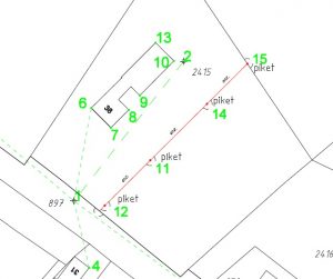
A Cadastral Surveyor performs cadastral surveying tasks, such as determining parcel boundaries and conducting verification surveys. You will enter this data into systems such as MOVE3D or AutoCAD Civil 3D and assist with property registration and boundary demarcation.
This function ensures clear property boundaries, legal certainty, and reliable land ownership records. As a result, transactions, land-use developments, and infrastructure projects can proceed on a stable foundation.
Key skills include:
A typical workday might look something like this:
Yes, Geo-ICT offers programs that will train you for this role and get you started—check out the Geo-ICT Traineeship job posting and apply today!
You can advance to roles such as Senior Cadastral Officer, Surveyor, or Geo-Data & Property Registration Specialist. Gaining additional experience with advanced surveying equipment, geospatial software, or real estate law will expand your career opportunities.
Although the core of the role involves cadastral surveying, knowledge of geoinformation (such as GIS, geodatabases, and GPS location analysis) gives you a clear competitive edge. This enables you to better integrate survey and boundary data into geospatially rich systems and contribute to a broader data-driven process.
This role involves adhering to quality standards regarding measurement accuracy, proper parcel registration, version control of maps and data, and compliance with legal requirements. Fieldwork also requires attention to safety and proper outdoor work practices.
You can apply directly for our Geo-ICT Traineeship or contact us via the widget on the page by entering your name, email address, and phone number to schedule a no-obligation conversation. You can also send us a WhatsApp message. If you have any questions about the program or whether the position is a good fit for you, please feel free to contact us.