Geo-ICT in Education

Geo-ICT Training Center, Netherlands, in collaboration with other educational institutions, offers vocational, higher vocational, and university-level programs in Geo-ICT

Wed UniGIS (MSc)

Geo-ICT Training Center, Netherlands participates in the advisory committee for the UniGIS program. Our instructors and trainees can enroll in this program, which we cover the costs for. If necessary, they can complete part of the pre-master’s program with us to qualify for admission.

Earning a Geo-ICT master’s degree while working is quite a challenge, but certainly not impossible. UniGIS is recognized worldwide and leads to an MSc in Geographical Information Sciences.

UNIGIS is a global network of universities that have been collaborating since 1990 to design and offer distance learning in geographic information systems and science.

Our instructors’ involvement in traditional education

Our instructors are regularly hired by traditional educational institutions. We teach at the vocational, higher vocational, and university levels. For educational institutions, this is often an effective way to address capacity and/or knowledge gaps.

HBO Geo-ICT (BSc)

  • The Central Register of Higher Education Programs (CROHO) does not assign a formal CROHO number to Geo-ICT.
  • Geo-ICT Training Center, Netherlands has therefore taken the initiative to integrate Geo-ICT modules into existing higher professional education (HBO) ICT curricula. Several HBO schools have adopted this approach.

Vocational Education (MBO) Geodata and Design

Geo-ICT Training Center, Netherlands is actively involved in the development of MBO Geo curricula. To ensure that MBO programs align as closely as possible with the labor market, a number of elective modules have been introduced in the Netherlands. The following elective modules are relevant to the geosector and registered with the Foundation for Vocational Education and Business (SBB)

  • Introduction to Geoinformation
  • Geo-ICT
  • Dimensioning Techniques
  • 3D Modeling in Infrastructure
  • Drone technology
  • Drone applications
  • Applying ICT on the Construction Site
  • Precision agriculture
  • Applied Spatial Design and Media Communications.

Two of our instructors are involved in developing the MBO Geodata & Design program. This program has already launched at three ROCs in the Netherlands:

MBO Surveying

SOMA College in Harderwijk offers an MBO Surveying program. We enjoy working with them by providing training courses for instructors, and one of our instructors is assigned to teach courses.

Earth Valley / Geo Department at ROC Midden Nederland

As part of the Earth Valley initiatives, ROC Midden-Nederland is in the process of establishing a geo department. This is funded by the RIF Geo-ICT – Amersfoort region.

Secondary Education

In secondary education, particularly in geography classes, QGIS is being used. A great deal of data and teaching materials are already available, for example on the EduGIS portal. To help teachers get started, we offer the GIS course for geography teachers and the GIS in Secondary Education course.

Step into the world of geoinformation

An increasing number of graduates from vocational education (level 4), higher professional education, and universities in fields such as:

Geography, Earth Sciences, Archaeology, Business Administration, Bioinformatics, Biology, Soil Science, Forestry and Nature Management, Chemistry, Cultural Heritage, Data Science, Defense, Animal Management, Ecology, Environment, Geodesy, Geomedia, History, Computer Science, International Business, Coastal and Marine Sciences, Agriculture, Surveying, Environmental Management, Environmental Science, Music Technology, Physics, Plant Sciences, Law, Spatial Development, Tourism, Water Management, Wildlife Management, Mathematics, Maritime Studies

choose our work-and-study program and often become trainees with us.

From the surveying sector to the geosector

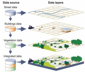
Thanks to rapid advances in information and communication technology (ICT), the surveying sector has evolved into the geospatial sector, which focuses on geospatial technologies and services. The emergence of geospatial data, satellite navigation, and geographic information systems (GIS) has significantly expanded the possibilities for geographic data acquisition, analysis, and visualization. As a result, surveyors can now perform more accurate measurements and solve complex geospatial problems. The geospatial sector has led to new applications in various fields, such as spatial planning, environmental management, transportation, agriculture, and smart cities, making the sector play a key role in understanding and utilizing the spatial environment.

Profile photo of Suzy Palmer-Smith. Our International Program Coordinator

My name is Suzy Palmer-Smith. Course Coordinator. Would you like more information?

Contact

Frequently Asked Questions

  • CAD (Computer-Aided Design) and GIS (Geographic Information System) are both technologies used for working with spatial data, but they have different applications and functionalities.
  • CAD focuses primarily on the design and modeling of physical objects, such as buildings, roads, and machines. It is often used in architecture, civil engineering, and mechanical engineering to create technical drawings and designs. CAD software offers advanced 2D and 3D drawing capabilities and supports detailed geometric operations.
  • GIS, on the other hand, focuses on collecting, managing, analyzing, and visualizing geographic data. It emphasizes the spatial context of data and enables users to understand relationships and patterns between different layers of information, such as land use, demographics, natural resources, and infrastructure. GIS software offers advanced map visualization, data analysis, and geospatial modeling tools.
  • The main difference between CAD and GIS is that CAD focuses on designing and modeling individual objects, while GIS focuses on understanding and analyzing geographic data on a broader scale. CAD focuses more on the technical aspects of objects, while GIS emphasizes the spatial relationships and context of data. However, both technologies can be complementary and, in some cases, integrated to tackle complex projects that require both design and spatial analysis.

ArcGIS and QGIS are both popular geographic information systems (GIS), but there are some key differences between them.

ArcGIS is a commercial GIS platform developed by Esri. It offers a comprehensive range of tools and features for data analysis, data management, and map visualization, with an emphasis on ease of use and support for enterprise solutions. It is often used in professional settings and provides extensive technical support and training opportunities, but it requires a license and can be expensive.

QGIS, on the other hand, is open-source GIS software available for free. It also offers a wide range of functionalities, including data analysis, data management, and map visualization, but with a greater emphasis on flexibility and customizability. QGIS is often used by researchers, academics, and communities seeking a cost-effective GIS solution. It has an active user community and offers customization options through plugins and extensions.

In general, both ArcGIS and QGIS can be used to perform geospatial analyses and create maps, but the main differences lie in licensing costs, ease of use, and the degree of customization. The choice between the two depends on the user’s specific needs and budget.

The European Copernicus program is an ambitious initiative by the European Union for Earth observation and monitoring of our planet. The program is designed to provide reliable and up-to-date information on various aspects of the environment and security. It comprises a network of satellites, in-situ sensors, and data services that collect data on topics such as climate change, air quality, land use, the marine environment, and natural disasters. This data is made freely available to users worldwide, including policymakers, researchers, businesses, and the public. The Copernicus program plays a crucial role in promoting sustainability, resilience, and informed decision-making in the fields of the environment and security.

Blended learning is an educational approach that combines traditional classroom instruction with online learning. This allows students to benefit from both face-to-face interactions with instructors and fellow students and the flexibility and personalized learning opportunities offered by digital tools.

There are various models of blended learning; we use the rotation model, in which students alternate between online learning and in-person classes according to a set schedule.

  • Start by emailing your resume and cover letter to anton.schutte@geo-ict.nl.
  • Next, we’ll schedule an online introductory interview, usually via Google Meet (Microsoft Teams is also an option).
  • After that, we’ll get right to work with you to make your resume appealing to the geospatial sector.
  • You can take a free course, such as QGIS Basics, so we can get to know each other better.
  • If we’re a good fit, we’ll make you an offer.
  • After your appointment, we’ll continue building your resume together and will quickly schedule interviews with one or more clients.
  • You’ll follow in the footsteps of the many trainees who came before you—successfully launching your career in the geospatial sector.

After the course, you’ll have another two weeks to ask the instructor questions. Since the instructor is already teaching other courses, it’s best to email your questions to info@geo-ict.nl. Your question will be forwarded to the instructor, and you’ll receive a response within 24 hours.

If you’re a bit further along and encounter practical problems you can’t solve on your own, it’s best to use Online Support. You’ll spend one day online with the instructor and receive personalized one-on-one instruction. All your problems will be resolved, and you’ll have made significant progress.

If you run into problems in practice that you can’t solve on your own, you have two options. You can sign up for a beginner or advanced course, or you can sign up for Online Support. You’ll spend a day online with an instructor and receive personalized one-on-one instruction. All your problems will be resolved, and you’ll have made significant progress.

If you’re pursuing a degree, it’s very important to know why you’re doing it and what you hope to achieve. For us, the priority is that you’re happy as a person and already have a job you really enjoy. That gives you a solid foundation. In addition to your studies, you can take advantage of more than 200 practical courses taught in small groups. This means you’ll have plenty of interaction with instructors and other professionals working in the field. You’ll build a strong professional network.

In addition, our study coaches and instructors will guide and support you throughout your studies. These study coaches and instructors have usually already completed the master’s program themselves, so they know what they’re talking about. We also continuously review your resume. It gets better and better as you earn more EC credits and complete practical courses.

Want to know more? Send an email to: suzy.palmer-smith@geo-ict.nl

  • That’s certainly possible. The big advantage is that you’re already working and earning a living. You won’t accumulate student debt. If you’re interested, please send your resume to anton.schutte@geo-ict.nl.
  • You’ll be pursuing the Geo-ICT associate degree program alongside your job. Click here for more information.
  • Also check out Simon. He completed the MBO surveying program at SOMA College in Harderwijk and is now pursuing the HBO Geo-ICT program.

Absolutely! Let your intuition guide you. Let your true wishes and desires come to the surface, and just go for it. Email your resume and cover letter to anton.schutte@geo-ict.nl, and we’ll schedule an online interview with you.