Explosives Investigation Course

Basisregistraties

In the Explosives Investigation course, you will learn how to use GIS in investigations of explosives and remnants of war in public spaces. Such investigations are conducted prior to all construction and infrastructure projects.

Course duration: 3 days
4
1

Taught by:

Tim Endeveld

Introduction to Explosives Detection

Geo-ICT Training Center, Nederland - Leergang Explosieven Onderzoek

In today’s world, it is essential to be aware of the traces the past has left in our environment. In particular, the remnants of explosives from conflicts such as World War II. Explosives survey plays a crucial role in the safety and development of construction and infrastructure projects by identifying and safely removing unexploded ordnance that still poses a risk. This discipline combines historical research, technological applications such as GIS (Geographic Information System) and QGIS, and fieldwork to provide a thorough analysis and evaluation of potential risks.

Our three-day Explosives Survey course offers an in-depth look at regulations, the detection process, and the application of QGIS in this specialized field. The course is designed not only to teach participants the necessary theoretical knowledge but also to provide practical skills through hands-on experience with practice data—from the basics of explosives survey to advanced analysis and reporting. Participants learn how to detect, identify, and secure explosive remnants of war for future generations.

With its focus on geodata and geoinformation technologies, Geo-ICT offers a unique opportunity to deepen expertise in this field. This is essential for anyone working in areas where history still influences the present.

The Importance of Explosives Investigation

The importance of explosive ordnance disposal cannot be underestimated. In areas where conflicts once took place, such as during World War II, unexploded ordnance often remains hidden underground. These unexploded remnants of war pose a significant risk—not only to people’s immediate safety but also to construction and infrastructure projects. Through explosive ordnance survey, these risks can be mapped and minimized.

Geo-ICT emphasizes the crucial combination of historical research and modern technology, such as GIS and QGIS, to identify and analyze potential hazard zones. This creates a safer environment in which to live and work. It also enables developers to make informed decisions when planning new projects. This research is not only vital for safety but also contributes to the protection of our heritage by safeguarding historical finds.

Understanding and applying geo-information and geodata in explosives research offers deeper insight into the impact of wars on our current environment and how we can use this knowledge for a safer future.

Fundamentals of Explosives Investigation

The fundamentals of explosives investigation are essential for anyone seeking to become proficient in this field. Our training program offers a thorough introduction to the core principles essential for the safe identification and handling of explosive remnants of war. This encompasses a broad spectrum of knowledge and skills:

  • Historical Preliminary Research: The importance of in-depth historical research to identify potential locations of explosives.
  • Risk Analysis: Learning how to effectively analyze and assess the risks associated with specific locations.
  • Application of GIS and QGIS: The practical use of geographic information systems for collecting, analyzing, and visualizing geodata.

Key aspects emphasized during the course include:

  • The importance of thorough preparation and research before conducting fieldwork.
  • How QGIS can be used to visually support historical data and risk analyses.
  • The necessity of safety protocols and procedures to ensure the safety of all involved.

These principles form the foundation for effective explosives investigation. The focus here is on both theoretical knowledge and practical application. Through this approach, Geo-ICT course participants can develop the in-depth understanding and practical skills necessary to work successfully and safely in this critical field.

What will you learn in the Explosives Investigation Course

GIS and QGIS Applications

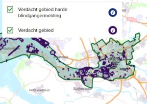
The application of GIS (Geographic Information System) and QGIS plays an indispensable role in the explosives investigation process. These technologies enable investigators to efficiently and effectively collect, analyze, and visualize geographic information. This is crucial for identifying potential risks and making informed decisions. Geo-ICT offers in-depth training on how these tools can be used for:

  • Conducting historical preliminary investigations and risk analyses, using QGIS to process and analyze relevant data.
  • Visualizing data to gain insight into the location of potential explosives and the environment in which they are found.

By learning practical skills with QGIS, participants gain the ability to apply theory in real-world situations. This enables them to make a valuable contribution to the safety of construction and infrastructure projects. This knowledge and these skills are essential for professionals involved in the detection of explosives, with an emphasis on integrating geodata into the investigation process to increase efficiency and effectiveness.

Analysis and Reporting Techniques

The Explosives Investigation course pays special attention to the analysis and reporting techniques essential for a thorough explosives investigation. These techniques encompass a wide range of skills and knowledge, from data collection to interpreting and reporting findings:

  • Data collection: Gathering relevant geoinformation and historical data to form a basis for further analysis.
  • Analysis: Using QGIS to analyze this data, recognize patterns, and identify potential risk areas.
  • Reporting: Compiling clear and understandable reports that present the results of the investigation, including recommendations and risk assessments.

These steps ensure that professionals in the field can not only identify the locations of potential explosives but also develop effective plans for their safe removal or handling. The ultimate goal is to ensure a safe environment for both current and future generations.

Why choose our Explosives Investigation Course?

Choosing Geo-ICT’s Explosives Investigation course is a choice for quality, depth, and practical applicability. This program stands out due to:

  • In-Depth Expertise: Geo-ICT brings a wealth of knowledge and experience in training professionals in the use of geoinformation technologies, specifically applied to explosives investigation.
  • Practical Approach: From day one, students are immersed in realistic scenarios. Through this, they gain hands-on experience with QGIS and other key techniques.
  • Broad Applicability: The skills you acquire are directly applicable across various sectors. This allows you to enter a broader professional field.

This training not only offers in-depth insight into the technical aspects of explosives investigation; it also emphasizes the practical application of this knowledge in the field. As a result, participants are fully prepared for the challenges they may encounter in their professional lives.

Read more

Enroll

€1695,- (VAT included)
  • Course duration: 3 days
Register for this course

Daily Schedule for Explosives Investigation Training

Day 1

On the first day of the explosives investigation course, the following topics will be covered:

Welcome and introduction to the course:

  • Overview of explosive materials and their properties.
  • Safety and ethics in explosives investigation.
  • Introduction to the use of Geographic Information Systems (GIS) in explosives investigation.
  • Installation and basic configuration of QGIS.
  • Introduction to the QGIS interface and tools.
  • Importing geographic data and maps into QGIS.

Day 2

  • Collecting field data using GPS technology.
  • Introduction to spatial data sources and GIS layers.
  • Data quality and accuracy.
  • Data management in QGIS: editing, organizing, and annotating data layers.
  • Spatial analysis tools in QGIS: measuring distances, creating buffer zones.
  • Practical exercises in data analysis for potential explosive ordnance survey.

Day 3

  • Principles of explosives investigation, including historical research and sources.
  • Identifying potential risk areas based on historical information and data analysis.
  • Introduction to geophysical methods for detecting buried explosives.
  • Practical application of QGIS in identifying potential suspect locations.
  • Creating maps and reports for explosive ordnance survey.
  • Case studies and group exercises using QGIS to map potential locations for explosives and remnants of war.
Course duration: 3 dagen
Sign me up

Learning Objectives for the Explosives Investigation Course

  • Understanding Explosives Investigation: Participants will gain theoretical knowledge about explosives investigation, including the history of explosives in the Netherlands, the types of explosives that may be encountered, and the associated risks.
  • Mastering QGIS: The course aims to familiarize participants with the use of QGIS as a powerful tool for data collection, analysis, and reporting. Participants will learn how to effectively use QGIS for map visualization, data management, and spatial analysis.
  • Practical Application: Participants will receive hands-on training to apply the knowledge gained in real-world scenarios. This includes using QGIS to collect and analyze data related to potential explosives, as well as preparing reports based on this data.
  • Identifying Risk Areas: A key learning objective of the course is to equip participants with the skills and knowledge necessary to identify potential risk areas. This means they will be able to recognize and assess potential explosive sites, which is essential for ensuring safe construction and infrastructure projects in areas historically associated with explosives.

Trainers

TE

Tim Endeveld

...
4.4
120 beoordelingen
260 studenten gingen je voor

M Blaauw

6 months geleden
Bekijk alle reviews

Want to know more?

Do you have questions about the course content? Or are you unsure whether the course aligns with your learning goals or preferences? Would you prefer an in-house or private course? We’d be happy to help.

Frequently Asked Questions About the Explosives Investigation Course

In this course, you will learn about the history of explosives, how to identify explosive remnants of war, how to use GIS and QGIS for data collection and analysis, and how to apply this knowledge to construction and infrastructure projects.

Yes, the course is designed for both beginners and experienced professionals who want to expand or refresh their knowledge of explosives investigation.

GIS is used to collect and analyze geographic data, which is essential for the investigation of explosives and remnants of war.

Yes, QGIS is one of the key tools covered in the course, with a focus on practical application in explosives investigation.

Absolutely; the course includes comprehensive training in analyzing collected data and preparing professional reports.

The course consists of an intensive 3-day training program that covers all essential aspects of explosives investigation.

The course covers the historical context of World War II, with a particular focus on its impact on the current landscape and the need for explosive ordnance disposal in areas containing remnants of war.

Yes, the course includes case studies and analyses of areas that were bombed during World War II, and how to apply this knowledge to modern explosives investigations.

Yes, the course covers the role of military aircraft in the war and their relevance in identifying potential locations of explosives.

The course covers the various types of conventional explosives used during the war and how they can be detected and safely removed today.

The course provides essential knowledge and skills for identifying and handling explosives, which is crucial for safety in construction and infrastructure projects at sites where unexploded ordnance may be present.