
In the "Determining WOZ Usable Area" course, participants learn about the BAG and WOZ systems and ensure that the area values are synchronized.
Basisregistraties
In the "Determining WOZ Usable Area" course, participants learn about the BAG and WOZ systems and ensure that the area values are synchronized.
 At the heart of every society lies the need to organize and make accessible its physical and legal reality. In the Netherlands, the System of Basic Registries forms the backbone that supports this need. These registries contain crucial information about citizens, businesses, and properties that the government needs to perform its duties efficiently. Among these basic registries is the Property Valuation System (WOZ). This is an essential component for both the government and its citizens.
The WOZ ensures a uniform valuation of real estate, which forms the basis for levying taxes such as property tax and water board tax. This valuation directly impacts the finances of every homeowner and business owner with real estate holdings. Geo-information and geodata play a crucial role in determining this WOZ value, utilizing digital architectural drawings, aerial photographs, and other geographic information.
The Basic Registration of Addresses and Buildings (BAG) (see our BAG Course here) is another vital component of the system, providing detailed information about the physical characteristics of buildings and addresses. This information is indispensable for conducting an accurate WOZ valuation. The synergy between BAG and WOZ registrations enhances the integrity and efficiency of taxation, spatial planning, and land registry management.
For professionals involved in real estate valuation, spatial development, or taxation, knowledge of these registries provides a foundation for performing their work with authority and accuracy. Understanding and applying geoinformation within these frameworks opens doors to more accurate decision-making and more efficient work processes.
Want to become a WOZ specialist? Then check out our WOZ course, where we delve deeply into WOZ from a GIS perspective.
Accurate area valuation plays a crucial role in determining the WOZ value of real estate. This valuation is not only fundamental to taxation but also to transparency and fairness within the real estate market. Below are the reasons why accurate area determination is so important:
The importance of a careful area valuation is further reinforced by developments in technology and geoinformation. Modern tools and software, such as Geo-ICT software, offer new possibilities for determining areas more accurately. This can be done using digital architectural drawings, aerial photographs, and oblique aerial photographs, which together provide a complete and detailed picture of a property.
Applying an accurate area valuation is therefore not only a matter of fairness and efficiency, but also a foundation for the reliability and integrity of the tax and real estate system in the Netherlands. With the right knowledge and tools, professionals in the geoinformation and real estate sectors can shoulder this responsibility and contribute to a fairer and more transparent system.
In the world of real estate valuation and taxation, the Basic Register of Addresses and Buildings (BAG) and the Real Estate Valuation (WOZ) play a central role. These registries are indispensable for accurate real estate valuation and play a key role in both government administration and the real estate sector. Let’s take a closer look at the specific roles of these two registries:
The interaction between the BAG and WOZ is particularly relevant for determining the WOZ value. The BAG provides the physical characteristics necessary for an accurate valuation in the WOZ process. For example, the area of a property, as registered in the BAG, is used to calculate the WOZ value. This synergy ensures consistency and transparency in the assessment of real estate.
The importance of accurate data cannot be overstated. Errors in the BAG registry or inaccuracies in the WOZ valuation have direct financial consequences for both governments and citizens. Therefore, it is essential that professionals in the real estate and geoinformation sectors possess the right knowledge and skills to work with these registries.
The use of advanced Geo-ICT tools and techniques plays an increasingly important role in improving the precision and reliability of these registrations. Through the use of digital architectural drawings, aerial photographs, and other geodata, the data in the BAG and WOZ can be determined with even greater accuracy.
The WOZ Area Course offers a thorough introduction to the BAG and WOZ basic registries. This is essential for professionals involved in real estate valuation and taxation. In this course, you will delve deeply into the methods and techniques required to perform accurate area valuations. This is crucial under the revised WOZ regulations. The course is spread over three intensive days, covering every aspect of determining usable floor area. Key learning points include:
This course is designed to equip you with the knowledge and skills to effectively use geoinformation and geodata in your work. You will be equipped with the tools to become an expert in determining WOZ areas. This is a skill that is becoming increasingly important in the world of real estate and taxation.
The practical application of Geo-ICT software is a crucial part of the WOZ Area course. Participants learn how to use these advanced tools to improve the accuracy of their area assessments. By gaining hands-on experience with the software, you’ll gain in-depth insight into the capabilities and features available to professionals in the world of geoinformation and real estate valuation.
Some highlights of what you’ll learn:
This hands-on approach ensures that the knowledge you gain is immediately applicable to your daily work. By integrating Geo-ICT software into your toolkit, you will not only become more efficient in your work but also more valuable as a professional in the field of geoinformation.
Determining usable floor area is a complex task that requires accuracy and knowledge of various methods. The course highlights different approaches, each with its own advantages:
These methods, combined with practical knowledge of using geodata, enable professionals to determine the usable area of real estate with confidence and precision.
Choosing the WOZ Area Course at Geo-ICT means choosing quality and expertise in the field of geoinformation. This course stands out because of:
The course is designed to provide you not only with theoretical knowledge but also with practical skills that you can immediately apply in your professional life. This makes our course the ideal choice for anyone who wants to deepen their expertise in WOZ valuation and geoinformation.
The "Determining WOZ Usable Floor Area" course begins with a presentation discussing the new WOZ regulations and what this means for current practices. Next, we’ll discuss ways to easily get your registration in order. After that, we’ll dive into (digital) architectural drawings and how to extract the correct data from them. You’ll also learn the methods needed to achieve the most reliable results possible.
On the second day of the “Determining Usable Floor Area for WOZ” course, we’ll be working with aerial photos and oblique photos. You’ll learn how to extract reliable data from these sources. You’ll also explore how 3D measurements can be applied. If you have specific questions related to your personal work environment that you would like answered, there will be time on this day to address them.

Do you have questions about the course content? Or are you unsure whether the course aligns with your learning goals or preferences? Would you prefer an in-house or private course? We’d be happy to help.
In this course, you will learn how to determine the floor area of properties subject to the WOZ assessment, with a focus on BAG registration and WOZ regulations.
This course is ideal for both new and experienced geoprofessionals, employees of companies in the geospatial sector, people seeking career transitions, and educational institutions looking to expand their knowledge in the areas of WOZ and geospatial ICT.
We use various geo-ICT software programs, including MOVE3, to apply the techniques we have learned in practice.
Yes, this course provides the essential knowledge and skills needed to start a professional career in the geospatial sector, particularly in WOZ and BAG administration.
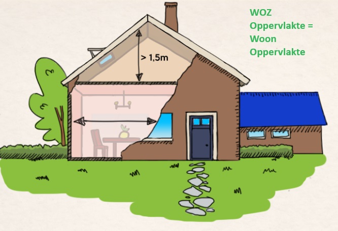
Starting January 1, 2022, it will be mandatory to assess WOZ properties based on floor area rather than volume. This will result in a more accurate and fairer assessment.
In the BAG, area values are recorded as the total area of the residential property, whereas in the WOZ these values are broken down among the sub-units, such as attached extensions.
Various sources are used to determine WOZ floor areas, such as (digital) architectural drawings, aerial photographs, oblique aerial photographs, and 3D measurements.
No, by using various sources, it is possible to determine accurate floor areas without having to visit and measure each building individually.
Mastering these skills enables professionals to conduct WOZ valuations accurately and efficiently, which is essential for accurate real estate appraisals.