Soil investigation plays a crucial role in our society, especially given the increasing complexity and demands of land use and environmental protection. This discipline is central to understanding and managing soil quality, which is essential for various sectors such as agriculture, construction, and environmental management. Soil investigation helps identify potential contaminants, assess the suitability of the soil for various purposes, and support sustainable land management. Using technologies and methodologies such as Geographic Information Systems (GIS) and the National Subsurface Registry (BRO), soil investigation provides detailed insights into soil composition, groundwater levels, and soil use history. These insights are indispensable for developing effective soil management strategies, preventing soil contamination, and supporting spatial planning and development. Through field research and advanced data analysis, the subsurface world is revealed, leading to better decision-making and a more sustainable future.
The Importance of Soil Investigation
Conducting soil investigations is essential to ensuring a safe and sustainable environment. It provides a foundation for decision-making in spatial planning, construction projects, and environmental protection. By analyzing soil quality, risks such as soil contamination are identified early on, thereby preventing costly remediation or health risks. Furthermore, soil investigation supports the development of sustainable land use and infrastructure, taking into account soil conditions and groundwater levels. The use of advanced technologies such as GIS and the National Subsurface Registry (BRO) enriches this research with in-depth analyses and insights, significantly improving the accuracy of project planning and environmental management. This lays the foundation for a future-proof approach to our living environment and natural resources.
Fundamental Principles of Soil Investigation
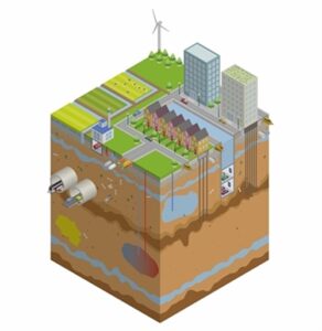
Soil investigation is based on fundamental principles that are crucial for the effective assessment and management of our soil and subsurface. It begins with understanding soil structures and soil types, which vary depending on geographic locations. The Basisregistratie Ondergrond (BRO) plays a key role in this, by providing a wealth of data that can be used for various analyses:
- Groundwater monitoring: To track groundwater levels and quality.
- Geotechnical borehole investigations: To determine the bearing capacity and composition of the soil.
- Soil analyses: To map soil types and contamination.
These principles are supported by technological tools such as GIS, which make soil data visually and analytically accessible. Understanding these basic principles is essential for anyone working in soil investigation, whether they are environmental consultants, urban planners, or construction professionals. The correct application of these principles leads to better decision-making and a more sustainable interaction with our living environment.
What will you learn in the Geodata Soil Investigation Program?
Soil investigation utilizes a range of techniques and tools that are essential for obtaining accurate and reliable data on soil quality and composition. Some of the most commonly used methods include:
- Groundwater monitoring and analysis: Crucial for understanding the water cycle and potential contamination.
- Geotechnical boring: Provides insight into the physical properties of the soil, which is important for construction and development projects.
- GIS and geographic data processing: Software such as QGIS allows for the visualization and analysis of soil data, contributing to a deeper understanding of soil maps and potential risks.
The integration of these techniques, supported by the National Subsurface Registry (BRO), enables professionals to conduct detailed analyses necessary for effective decision-making and sustainable soil management.
Analysis and Application of Soil Data
The analysis and application of soil data are crucial steps in soil investigation that help inform decisions for environmental and construction projects. Using advanced GIS technologies and data analysis methods, soil characteristics—such as composition, contamination, and suitability for various land uses—are thoroughly evaluated. These analyses make it possible to:
- Identify and mitigate potential environmental risks.
- Support sustainable land and water management.
- Facilitate the development of accurate soil maps and geographic presentations.
These processes are essential for professionals in the geoinformation sector to make accurate decisions that contribute to sustainable development and the management of natural resources.
Why choose our Geodata Soil Investigation Course?
Choosing the Geodata Soil Investigation training at Geo-ICT is a decision that can give your career in geoinformation a significant boost. This training program stands out because of:
- Expertise and Experience: Geo-ICT is a market leader in geoinformation education, with a rich history of offering high-quality, up-to-date courses.
- Practical Approach: Our courses are designed to provide you not only with theoretical knowledge but also with practical skills that are immediately applicable in your work.
- Certification: At the end of the course, you will receive a certificate that recognizes your expertise and significantly increases your value in the job market.
By choosing our course, you are investing in yourself and your future within the dynamic world of soil investigation and geoinformation.