
Discover the key principles of the WOZ Act (Real Estate Valuation Act) and expand your knowledge during our engaging WOZ training course, which takes a GIS-based approach.
Basisregistraties
Discover the key principles of the WOZ Act (Real Estate Valuation Act) and expand your knowledge during our engaging WOZ training course, which takes a GIS-based approach.

In the world of geoinformation and geodata, the Real Estate Valuation (WOZ) plays a crucial role. But what exactly does this entail? The WOZ is a system established by the government to assign a value to all real estate, such as homes, offices, and other buildings, in the Netherlands. This valuation serves as the basis for various taxes and levies, including the property tax that property owners are required to pay.
The value is determined annually and is an estimate of the selling price of your property on the valuation date. This valuation date falls one year before the start of the calendar year. This estimate is made by the municipality, based on characteristics such as size, location, and type of property, while also taking into account market developments in the surrounding area.
Geo-ICT plays an indispensable role in this process by offering training courses that delve deeply into the geographic component of WOZ registration. By understanding and being able to apply geo-information within this framework, as a WOZ employee you will not only become proficient in assessing WOZ property maps using QGIS, but you will also learn how to effectively use this data within the WOZ process.
This introduction to the WOZ offers a glimpse into the complexity and importance of these valuations—not only for tax purposes but also for broader applications within municipalities and water boards. By taking our WOZ Course, you will not only gain theoretical knowledge but also learn practical skills that you can immediately apply in your work.
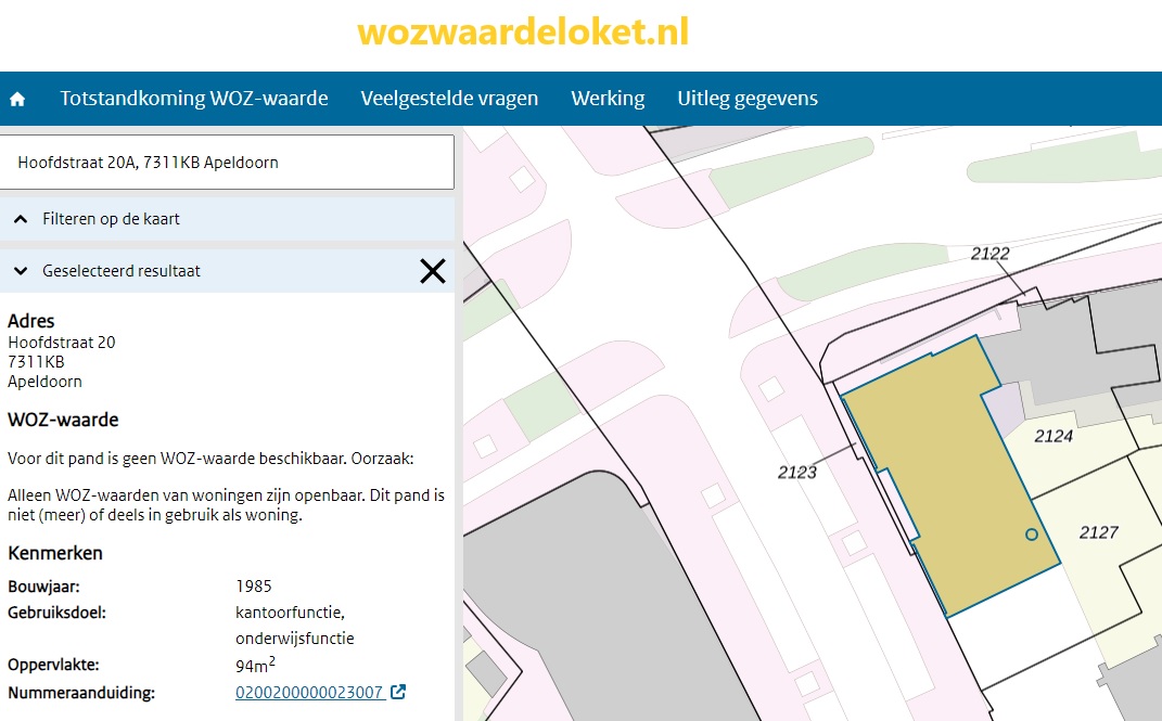
The open-source software product QGIS is used to facilitate interaction. Some basic knowledge of QGIS is desirable but not strictly required. Also check out our course on determining WOZ area under the new regulations.
The Property Valuation (WOZ) forms the cornerstone of the Dutch property tax system, but how exactly does this system work? Let’s start at the beginning: the WOZ value is an estimate of the market value of a property on a specific reference date, usually January 1 of the previous year. This estimate serves as the basis for various taxes, such as property tax, the owner-occupied home allowance for income tax, and water board tax.
What makes this system unique is that it provides a standardized method for determining the value of all real estate in the Netherlands. Municipalities are responsible for setting these values, using a combination of geodata, market data, and specific characteristics of the property, such as location, size, and building type.
For professionals in the field of geoinformation, understanding the WOZ procedure is essential. With the WOZ Course, Geo-ICT offers an in-depth exploration of the subject. You will not only learn about the legal and policy frameworks of the WOZ but also gain hands-on experience with the tools used to determine and maintain WOZ values, such as QGIS. This software is indispensable for mapping and analyzing WOZ properties and their attributes.
The course goes beyond just technical skills; you’ll also learn how these valuations impact citizens and businesses, and how, as a WOZ employee, you can make this information understandable and accessible. This understanding and these skills are crucial for anyone working with geodata in the context of the WOZ, whether at a municipality, water board, or consulting firm.
The Property Valuation System (WOZ) plays a key role in the functioning of both municipalities and water boards. These institutions rely on accurate WOZ valuations to finance and manage essential services. But what makes the WOZ so important to them?
Beyond these primary functions, accurate WOZ valuations offer additional benefits:
The use of geoinformation and advanced software tools such as QGIS enables municipalities and water boards to base their WOZ valuations on the most current and accurate data. This not only contributes to a fairer tax system but also to more effective management of our living environment.
When you delve into the Property Valuation (WOZ), you’ll quickly come across the terms “objects” and “attributes.” But what exactly do these terms mean? Let’s take a closer look:
The WOZ Course at Geo-ICT delves deeply into this subject and offers participants a clear overview of:
In this course, you will learn, among other things:
Correctly identifying and registering these elements is invaluable for anyone working in the field of geoinformation. Knowledge of the correct WOZ objects and attributes enables professionals to contribute more effectively to the WOZ process, leading to fairer taxation and better-informed decision-making within municipalities and water boards.
At the heart of the Property Valuation (WOZ) system lie the basic registries and geographic components. These elements are indispensable for accurately determining the WOZ value. But how exactly do they contribute to this process?
The interplay between basic registries and geographic components provides a robust foundation for the WOZ valuation process:
In the WOZ Course at Geo-ICT, you’ll gain in-depth insight into the role of these basic registries and geographic components. You’ll learn how to interpret and apply this data within the WOZ valuation process. In addition, Geo-ICT offers practical training in the use of advanced GIS tools, such as QGIS, which allow you to perform geographic analyses and assess the impact of location on the WOZ value.
QGIS plays a central role in the world of geographic information, especially when it comes to property valuation (WOZ). This open-source geographic information system (GIS) software offers a powerful platform for analyzing, visualizing, and managing geodata. For professionals involved in WOZ valuations, practical skills with QGIS are indispensable.
Using QGIS within the WOZ process enables you to:
The WOZ Course at Geo-ICT includes a module dedicated to working with QGIS, where you’ll learn how to use this tool for:
Through Geo-ICT’s hands-on approach, you’ll develop not only theoretical knowledge but also the practical skills you need to excel as a WOZ professional. You’ll learn how to effectively use QGIS to visualize, analyze, and interpret geodata. This will enable you to make a valuable contribution to the WOZ valuation process.
These skills enable you to make complex geographic information accessible and translate it into accurate and equitable WOZ valuations.
When choosing a course on the Property Valuation (WOZ), you want to be sure you’re investing in quality, relevance, and practical applicability. Our WOZ training stands out thanks to a unique combination of factors you won’t find anywhere else. Here are a few reasons why our course is the perfect choice for professionals in the geoinformation sector:
Choosing the WOZ Course at Geo-ICT means choosing to invest in yourself, in your professional development, and in the future of your career. With our blend of in-depth knowledge, practical skills, and personalized approach, we offer everything you need to excel in the world of geoinformation and WOZ valuations.
Introduction to Basic Registries and the WOZ. What is the WOZ, and how, when, and why was it established? We’ll take a look at some of the property types registered in the WOZ.
Moving on to property types. All types of WOZ properties will be examined in detail using examples and special cases. Accurate property delineation is crucial in this context. The attributes (properties) of the properties will be discussed in detail.
The lifecycle of the objects is defined by events that cause their status to change. We will examine all of them. We will then conclude with QGIS, which allows us to visualize selections of the WOZ data on the map and generate a WOZ object map. With an up-to-date WOZ object map, the WOZ staff member can verify the accuracy and completeness of the object boundaries and cadastral records. Consider, for example, the registration of allocated floor area for rental properties. WOZ object maps also offer a wide range of possibilities for creating thematic maps on current policy topics such as market developments, objections, and vacancy rates.

Do you have questions about the course content? Or are you unsure whether the course aligns with your learning goals or preferences? Would you prefer an in-house or private course? We’d be happy to help.
The WOZ Course is a specialized training program focused on the WOZ Act and relevant geospatial software, designed for both newcomers and experienced professionals in the geospatial sector.
This course is ideal for both new and experienced geospatial professionals, companies in the geospatial sector, people seeking career transitions, and educational institutions looking to expand their knowledge of the WOZ Act and related geospatial software.
The course lasts three days and covers both the theoretical and practical aspects of the WOZ Act, basic registrations, and the use of WOZ property maps in QGIS.
A basic understanding of geographic information systems is recommended for this course, but it is not a strict requirement. Beginners are also welcome to participate.
The course includes training in the use of QGIS and other relevant geographic information systems (GIS) software, with a focus on WOZ property maps and basic registries.
Yes, the course is also suitable for people looking to change careers and considering a move into the geosciences sector who want to gain a basic understanding of the field.
The course is primarily offered in person, but there may also be options for online or blended learning. Please contact us for current options.
Prices vary; for current pricing information and financing options, please contact Geo-ICT Training Center directly.
This course stands out for its specific focus on the WOZ Act and its practical application in geographic information systems, which is unique among the available courses.