The BAG plays a central role in ensuring a solid and reliable data foundation. Accurately recording and keeping this data up to date is essential for the efficient management and use of space. It also plays a key role in sustainability, safety, and economic development.
Developing and managing the BAG requires an understanding of both the technical aspects of georeferencing and the legal and organizational frameworks. It offers a fascinating insight into how data about our physical world is collected, managed, and applied to improve our society. For professionals who wish to delve deeper into this field, the BAG Course offers an excellent opportunity to develop both theoretical knowledge and practical skills.
This training not only informs participants about the ins and outs of the BAG. It also prepares and motivates them to take an active role in the management and development of this essential national data source. Through a combination of expert instruction, hands-on exercises, and interactive sessions, participants are equipped to contribute to the quality and accessibility of geoinformation in the Netherlands.
For the necessary interaction, the open-source software product QGIS is used, and where possible, the participants’ current BAG data. Prior knowledge of QGIS is not required, but it is helpful.
More interested in what the BGT (Basic Large-Scale Topography Registry) does? Then the BGT course might be for you!
The Basic Register of Addresses and Buildings (BAG) plays a crucial role in the Dutch geoinformation landscape. This register ensures that data on all addresses and buildings in the Netherlands is available centrally and uniformly. But what really makes the BAG so important for professionals working with geoinformation?
- A foundation for modern government and business: In a world where data is becoming increasingly important, geodata forms the basis upon which decisions are built. The BAG contributes to a reliable, up-to-date, and high-quality digital representation of the Netherlands.
- Crucial for spatial analysis and decision-making: Approximately 80% of all information has a spatial component. This means that information—from subsidies to demographic data—can be linked to locations. The BAG makes it possible to analyze this data spatially and visualize it, often adding value by revealing geographic relationships and clusters.
- Indispensable for geo-applications: The development of applications such as Google Maps and GIS systems would not have been possible without the underlying geo-information from registries such as the BAG. These technologies, in turn, have increased the accessibility and use of geo-information.
- Interconnection with other basic geographic registries: The BAG does not stand alone but is part of a network of basic registries. Together, this network forms a detailed digital map of the Netherlands. Continued development in conjunction with other registries ensures a flexible and robust foundation for geographic data.
The role of municipalities and the Land Registry
- Municipalities as data holders: Municipalities are responsible for entering data into the BAG and ensuring its quality. They make this data available via the National BAG Facility (LV BAG).
- The Land Registry manages the LV BAG: The Land Registry plays a key role in managing the BAG and making data available to users. These users are often government organizations that use BAG data to carry out their public duties.
The BAG is therefore much more than just a registry of addresses and buildings; it is an essential building block within the geoinformation domain, contributing to a wide range of social and economic processes. By linking data to locations, the BAG offers added value that goes beyond the sum of the individual data points. This makes it an indispensable tool for anyone working with geoinformation.
Overview of the BAG: Definitions and Key Components
The Basic Register of Addresses and Buildings (BAG) is the foundation of the Dutch geoinformation domain, with precisely defined terms and structures. Here is a simple overview of some key components:
- Addresses: Combinations of residential area, public space, and number designation, which uniquely identify a location in the Netherlands.
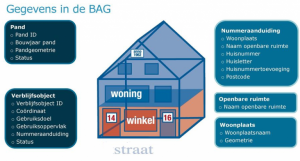
- Object types: The BAG distinguishes between various object types, such as buildings, residential properties, sites, and berths. Each object type has unique characteristics and serves a specific purpose within the registry.
- Intended use: Specifies the function(s) of addressable objects, such as residential or commercial use.
- Life cycle: Every BAG object goes through a life cycle from creation to potential demolition, with statuses indicating the current phase.
The registration and maintenance of this data ensure a structured and unambiguous way of working across the entire geoinformation domain. This makes the BAG indispensable for government, the business community, and citizens for a wide range of applications, from spatial planning to crisis management.
What will you learn in the BAG program
Basic principles of the BAG and its historical context
In the BAG course, we delve deeper into the rich history, the fundamental building blocks, and the application possibilities of this crucial database. You will learn about the technical details, such as how data on the year of construction, area, intended use, and exact location of every address and building in the Netherlands is recorded and maintained. You will also learn about the impact of this data on social and economic processes. The course highlights how the BAG serves as the backbone for numerous applications within both the public and private sectors, ranging from urban planning and real estate management to crisis management and emergency response. Through case studies and practical examples, you’ll gain insight into how this data is used to support decision-making, develop policy, and create innovative solutions. In addition, attention is given to the collaboration between various government agencies and the management of the BAG by the Land Registry, including the challenges and opportunities that this collaboration entails.
Objects, Attributes, and Events in the BAG
In the course on the Basic Registration of Addresses and Buildings (BAG), you will dive deep into the world of BAG objects, their attributes, and the key events that affect these objects. The BAG is structured around a number of core objects, such as buildings, residential properties, sites, and berths. Each has unique properties and a specific role within the registration system. You will learn about:
- The objects: How they are defined and identified with a unique identifier.
- Attributes: The characteristics of each object, such as year of construction, area, and use.
- Events: Significant moments such as construction, renovation, subdivision, and demolition, which influence the status and characteristics of objects.
This course provides a thorough understanding of how BAG data is structured and how it can be applied in various fields, from urban planning to emergency services.
Why choose our BAG training?
The BAG Course at Geo-ICT is an excellent opportunity for anyone who wants to delve into the world of geoinformation. This course stands out through a combination of expert instruction, hands-on exercises, and interactive learning experiences. You will not only learn the theoretical foundations of the Basic Register of Addresses and Buildings but also gain practical skills to apply this knowledge in your work or studies. The program is designed to thoroughly prepare participants for a wide range of challenges and opportunities within the field.