Job Title: 3D Scan Operator

A 3D scan operator is responsible for creating digital 3D scans of objects or buildings. This can be done, for example, using laser scanning or photogrammetry. The 3D scan operator is responsible for setting up the scanning equipment, performing the scan, and processing the scan results.


What a 3D Scan Operator Does

As a 3D scan operator, you’re the behind-the-scenes artist who digitally captures the world around us. Your role is crucial for creating accurate 3D models of objects and environments. But what exactly does this job entail? Let’s take a look at a typical day:

  • Performing scans: You spend your days carefully scanning objects and buildings. Each scan is a building block for a larger whole.
  • Planning and preparation: Before the scanner starts whirring, you’re busy planning the scan positions and adjusting the scan settings. These preparations ensure that every detail is captured.
  • Working with advanced technology: Your hands operate both laser scanners and photogrammetric cameras—tools essential for capturing our physical world in digital form.
  • Quality control: After the scans comes quality control. You search for technical issues and errors, ensuring the collected data is of the highest quality.
  • Data processing: You’ll use the collected data to generate point clouds and mesh models—the building blocks of every 3D model.
  • Generating 3D Models: The most creative part of your work. You bring the scans to life by texturing them, creating lifelike 3D models.

Your work as a 3D scan operator is not only technically challenging; it is also an essential link in the chain that helps create digital worlds, from designing buildings to reconstructing historical sites. By bridging the gap between the physical and digital worlds, you play a vital role in diverse projects and industries.

Are you ready for this challenging and rewarding career? Your expertise in geoinformation and 3D scanning opens doors to unprecedented possibilities.Geo-ICT Training Center, Nederland - Functie 3D-Scanoperator

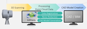
Why is the work of a 3D scan operator important?

The profession of 3D scan operator is not only fascinating but also crucial to many sectors. Why? Because the digital replicas you create form the basis for innovations and developments in countless fields. Here are a few reasons why your work matters:

  • Precision and efficiency: By capturing objects and environments down to the smallest detail, you contribute to accurate and efficient planning in construction projects, product design, and even the entertainment industry.
  • Cultural heritage: You help preserve cultural heritage by digitally documenting historical monuments and artifacts, ensuring they are preserved for future generations.
  • Fostering innovation: The data and models you produce are essential for research and development in science, architecture, and urban planning, with every scan opening up new possibilities.
  • Improving safety: In the industrial sector and in infrastructure projects, your work is used to conduct safety analyses, mitigate risks, and improve safety for everyone.

Your role as a 3D scan operator goes beyond simply operating technical equipment; you are a key figure in shaping our future. By translating the physical world into accurate digital models, you open the door to new discoveries and help build a better world.

The Impact of Geoinformation on a 3D Scan Operator

Geo-information plays an indispensable role in the work of a 3D scan operator. This information is not only crucial for capturing the physical world, but also for its interpretation and practical application in digital models. Here are some ways in which geo-information makes a difference:

  • Location determination: For accurate scanning, it is essential to know exactly where each object is located in space. Geoinformation helps determine these locations.
  • Scan planning: With geoinformation, you can determine the most effective scan positions and routes, allowing you to work efficiently and collect the highest quality data.
  • Analysis and application: After collecting scans, you use geoinformation to analyze the collected data and convert it into usable models for various purposes.

Understanding and applying geoinformation enables you, as a 3D scan operator, to perform your work with greater precision and effectiveness, thereby contributing to the development of accurate and valuable digital models.


Informeer & Solliciteer

Want to know more?

Do you have questions about the course content? Or are you unsure whether the course aligns with your learning goals or preferences? Would you prefer an in-house or private course? We’d be happy to help.

Opleiding

As a 3D scanning operator, you have followed a unique path through specialized courses that have shaped your expertise and knowledge in this field. You laid the foundation with the 3D Scanning Course and the Surveying Course, where you learned the ins and outs of scanning and surveying land. With Revit Architecture, you bridged the gap to modeling complex structures in 3D, while Remote Sensing gave you insight into interpreting data from space. Finally, the Drone Surveying Course has expanded your skills in the air, enabling you to collect and analyze data from a new perspective. Each of these courses has contributed to your ability to capture the world in 3D with precision and creativity.

Taken

As a 3D scan operator, you play a crucial role in digitizing the physical world. Your responsibilities are wide-ranging and vary from the preparation to the final processing of the scans. Your core activities include:

  • Scan planning and preparation: You carefully select the location and the best angles for the scans. You take the object and environmental factors into account to ensure that each scan contributes optimally to the final result.
  • Performing scans: Using advanced equipment, such as laser scanners and photogrammetric cameras, you capture objects and environments. Your precision and attention to detail are essential for obtaining high-quality data.
  • Quality control and data processing: After scanning, you conduct a thorough review of the collected data. You use specialized software to process the data into usable 3D models, correcting any errors to ensure the highest quality.

These tasks require not only technical skills but also a keen eye for detail and a passion for precision. Your work contributes to a wide range of applications, from architecture to heritage preservation.

Frequently Asked Questions About the 3D Scan Operator Position

A 3D scanning operator is responsible for creating digital 3D scans of objects or buildings (e.g., using laser scanners or photogrammetry) and processing the resulting point clouds into usable 3D models.

This role is important because accurate 3D digital models and point clouds form the foundation for construction projects, renovations, heritage monitoring, infrastructure planning, and other geoinformation applications. Your work ensures that physical environments are captured digitally with high quality.

Geo-information plays a key role in Geo-ICT: you use location and scan data, and geo-information helps with planning scan positions, interpreting data, and integrating point clouds into geo-models.

Key skills include:

  • Experience with laser scanners, photogrammetry, and 3D scanning systems.
  • Ability to process point clouds into 3D models (mesh, texturing) and perform quality control on scans.
  • An affinity for geoinformation, positioning, and location analysis is a plus.
  • Accuracy, technical insight, and a willingness to work both outdoors and indoors (field + office).

These skills can be learned, among other things, during the 3D Scan Operator course.

A typical workday might include:

  1. Preparing a scanning assignment: determining locations and setups, coordinating with the client.
  2. Performing scanning work on-site (objects, buildings, terrain).
  3. Back at the office: quality control of the scans, processing the point clouds, generating 3D models.
  4. Consulting with colleagues or clients regarding results or next steps.

You can advance to roles such as Senior Scan Operator, 3D Modeler/Point Cloud Specialist, or BIM/Geo-Data Integrator. Additional expertise in geoinformation technology, modeling, or project management will enhance your career prospects.

Although the core of the role involves technical scanning, knowledge of geoinformation (such as GPS positioning, GIS, and geodatabases) will give you a clear competitive edge in this position at Geo-ICT. It will help you perform and process scans more effectively and accurately.

This position requires adherence to quality standards such as: proper setup and calibration of scans, accurate recording of location and data, and professional processing of point clouds. Working safely on-site (whether outdoors or indoors) and maintaining proper documentation are also required.

You can apply directly for the Geo-ICT Traineeship position or contact us via the widget on the page by entering your name, email address, and phone number to schedule a no-obligation conversation. You can also send us a WhatsApp message. If you have any questions about the role or whether it’s a good fit for you, please feel free to contact us.