Data Engineer Position

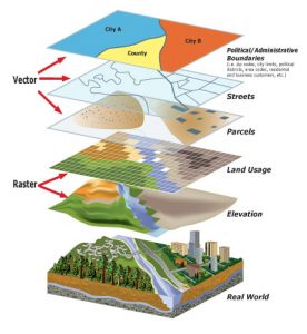
A geospatial data engineer is responsible for designing, implementing, and maintaining geospatial systems and infrastructure. They work with geospatial technologies such as geographic information systems (GIS), GPS, and remote sensing to collect, store, and analyze geographic data. They are involved in setting up geospatial databases, developing geospatial applications, and managing geospatial software and hardware.

What a Data Engineer Does

As a Data Engineer, you’re the unsung hero behind the scenes who ensures that data isn’t just collected, but actually speaks volumes. With your knowledge and expertise, you turn raw data into gold mines of insight and innovation. This includes:

  • Designing and implementing geospatial databases and data models, ensuring that geographic data is stored and managed efficiently. This is a core part of your role.
  • Integrating various data sources, such as satellite imagery and GPS data, to form a rich and complete picture of the geographic context.
  • Developing and implementing advanced analytical methods and tools to extract in-depth insights from geospatial data, making your role indispensable in every project.
  • Setting up automated workflows and applying data compression techniques to increase efficiency and reduce costs.

As a geospatial data engineer, you have a significant influence on how organizations handle the ever-growing volume of data. You are not only a bridge-builder between data and decision-making, but also a pioneer who paves the way for new discoveries. Your work is crucial in a world where geographic information is becoming increasingly important for policy development and decision-making. With GIS knowledge and expertise in Python, R programming, MATLAB, SQL, and QGIS, you have the tools to bring data to life and thereby make an essential contribution to societal and organizational challenges.

Why is the work of a Data Engineer important?

In the digital age, geographic information plays an increasingly significant role in decision-making processes and policy development. The role of a Data Engineer is indispensable in this context because of:

  • Innovation and efficiency: By converting complex data into actionable insights, Data Engineers enable organizations to innovate faster and more efficiently.
  • Better-informed decision-making: The analysis and interpretation of geospatial data help shape policies and strategies based on accurate and up-to-date information.
  • Social impact: Data Engineers contribute to solving complex social issues, from climate change to urban planning, through the power of geospatial information.

Given the essential role that geospatial information plays across diverse sectors, from government policy to business strategies, the expertise of a Data Engineer is crucial. Their work ensures that data is not only collected and stored, but also transformed into insights that shape and improve the world around us.

The Impact of Geoinformation on a Data Engineer

Geo-information is the compass that guides a Data Engineer, an essential resource that transforms the way we understand and interact with the world. Its impact on the role includes:

  • Enrichment of data analysis: Geoinformation adds a spatial dimension to data analysis, revealing new insights and patterns that would otherwise remain invisible.
  • Decision-making and planning: It enables advanced decision-making and strategic planning for sectors ranging from urban planning to environmental management.
  • Stimulating innovation: It opens the door to innovative solutions in various fields such as transportation, logistics, and public safety.

Informeer & Solliciteer

Want to know more?

Do you have questions about the course content? Or are you unsure whether the course aligns with your learning goals or preferences? Would you prefer an in-house or private course? We’d be happy to help.

Opleiding

To excel as a data engineer in the field of geoinformation, completing a bachelor’s or master’s degree is essential. A specialized Data Analysis and GIS program forms the foundation, featuring in-depth courses in Python and Data Science, R Programming, MATLAB, SQL, and QGIS. This knowledge is reinforced by the experience gained at the Geo-ICT Training Center in the Netherlands, where you’ll be prepared for secondment to leading organizations. Your expertise in GIS and Geo-Basic Registries enables you to contribute to projects at municipalities, the Land Registry, engineering firms, and more, where you transform complex data into valuable insights.

Geo-ICT Training Center, Nederland - Functie Geospatial Data-Engineer

Taken

As a Data Engineer, you play a crucial role in the world of geospatial information. Your responsibilities are diverse and of great importance:


  • Designing and implementing geospatial databases and data models to efficiently organize and manage geographic data.
  • Integrating various data sources, such as satellite imagery and GPS data, to form a holistic view of geographic contexts.
  • Developing and implementing advanced analytical methods and tools to extract in-depth insights from geospatial data.
  • Setting up automated workflows, applying data compression techniques, and optimizing query performance to make data analysis more efficient.


These tasks underscore the importance of your role in leveraging geospatial information for better decision-making and innovation.

Frequently Asked Questions About the (Geospatial) Data Engineer Position

A Data Engineer in the geospatial sector is responsible for designing, implementing, and maintaining geospatial systems and infrastructure. You work with geographic data (satellite imagery, GPS data, sensors) and build the data models and workflows that transform this raw data into valuable insights.

As geospatial data becomes increasingly important in policy development, infrastructure, the environment, and spatial planning, a Data Engineer ensures that data is managed and utilized efficiently. This enables organizations to make faster and more informed decisions.

At Geo-ICT, the focus is on the intersection of data engineering and geoinformation: you’ll work with geospatial databases, integrate various data sources (such as GPS, satellite, and field measurements), and build automated workflows for geodata. This makes the role more technical and specialized than that of a standard data engineer.

Key skills include:

  • Proficiency in programming languages such as Python, R, or MATLAB, and in SQL.
  • Knowledge of geographic information systems (GIS), geodatabases, and data modeling.
  • Experience integrating various data sources and building automated workflows.
  • Analytical insight and the ability to transform complex datasets into structured and actionable information.

A typical workday might look something like this:

  1. You start by analyzing new geographic data sources: satellite images, GPS measurements, or sensor data.
  2. You build or maintain the data models or databases in which this data is stored.
  3. You develop or optimize ETL/ELT processes (Extract, Transform, Load) to make data available for users or analysis.
  4. You collaborate with GIS specialists, data analysts, or policy staff to ensure that the right data is available on time and in the right quality.
  5. You monitor data quality, performance, and automation gaps, and implement improvements.

Yes, Geo-ICT offers programs that train you for this role so you can start working right away. Check out the Geo-ICT traineeship job posting. Not sure if this is the right fit for you yet, but interested in working in the Geo-ICT sector? Even then, the traineeship might be just what you’re looking for!

You can advance to roles such as Lead Data Engineer, Geo-Data Platform Architect, or Machine Learning/Geo-Data Specialist. By gaining additional expertise in cloud platforms, DevOps for data, or geoinformation technology, you can enhance your career prospects.

Although a Data Engineer can already accomplish a great deal with general data engineering skills, knowledge of geoinformation (such as GIS, geodatabases, and location analysis) will significantly strengthen your role at Geo-ICT. You will then be able to contribute directly to projects with a strong focus on geoinformation.

This role involves adhering to quality standards related to data quality, data governance, and the reliability of datasets. It also focuses on data security, accurate metadata, version control, and workflow documentation to ensure that the geodata is reliable and reusable.

You can apply directly for the Geo-ICT Traineeship position or contact us via the widget on the page by entering your name, email address, and phone number to schedule a no-obligation conversation. You can also send us a WhatsApp message. If you have any questions about the job description or whether the position is a good fit for you, please feel free to contact us.