
An overview to help you quickly find the information that's relevant to you—from our trainees to specific Geo-ICT roles.

An overview to help you quickly find the information that's relevant to you—from our trainees to specific Geo-ICT roles.

In the Netherlands, we’ll be undertaking a great deal of work in public spaces over the coming years. All the clients involved in these projects are looking for staff. Geoinformation is crucial to this effort.
We offer highly trained professionals who are experts in creating, using, and maintaining geoinformation. These flexible professionals can immediately add value to your projects in the following areas:
are increasingly faced with specific requirements and complex projects, making it difficult to quickly find qualified personnel.
Our trainees offer the solution: highly educated, flexible, and continuously developing through additional training. Thanks to this ongoing training, our trainees seamlessly align with your organization’s needs. In addition, we offer flexible secondment, giving you the option to hire the trainee at no cost after one year. This minimizes your risk and ensures you bring in young talent who can grow within your organization.
Let us know what you need, request a consultation directly via our contact page, and discover within one week which trainee is the perfect fit for your organization.
Our trainees are not only highly educated, but also continuously develop their skills through additional training and hands-on experience. They are certified in the use of leading software such as ArcGIS, QGIS, AutoCAD, and FME, making them immediately ready to take on a variety of tasks in the public sector where geoinformation is of critical importance. Whether you need a CAD drafter, GIS specialist, surveyor, or BGT administrator, our trainees adapt effortlessly to your specific requirements.
Thanks to their ongoing training and practical experience, our trainees are flexible and can be deployed for both short- and long-term projects. Furthermore, we offer a unique opportunity: after one year, you can hire the trainee at no cost, allowing you to attract young talent to your organization risk-free.
Hiring flexible staff through our secondment service offers numerous benefits for organizations seeking expertise in geoinformation. Flexibility and risk mitigation are our top priorities, with the option to hire a trainee at no cost after one year.
We have now placed more than 200 trainees with over 50 different clients. Our clients particularly value the continuity and the ease with which our professionals fit seamlessly into their teams.
Key benefits of our trainees:
Our trainees specialize in various roles related to working with geoinformation, allowing us to provide a suitable professional for every challenge.
Whether you need a GIS specialist, surveyor, BGT administrator, or another role, our trainees are immediately deployable and adapt quickly to your project requirements.

Below is an overview of the key roles and areas of expertise in which our trainees excel:
Our GIS specialists are deployed at organizations such as Alliander, Rijkswaterstaat, water boards, and municipalities. They process and analyze geographic information to support governments and businesses in areas such as the energy transition, network management, or infrastructure planning.
A GIS specialist is indispensable for projects involving the collection, management, or visualization of spatial data—such as asset management, mobility issues, spatial planning, or network management.
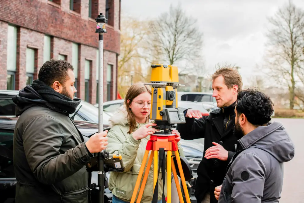
Our surveyors and quantity surveyors work for companies such as Geomaat, Facto Geo, and the Prima Group. They perform precise measurements and quantity surveys for a wide range of projects in construction, infrastructure, and civil engineering.
Surveyors are crucial in preparing and overseeing physical projects. Examples include staking out construction sites, surveying parcels, or inspecting infrastructure assets.
Our CAD drafters are active, for example, in projects for BAM and Tata Steel, where technical drawings play a key role.
For design and engineering projects requiring precision, our CAD drafters ensure the correct working drawings, revision drawings, and 2D/3D models are produced, often in AutoCAD, MicroStation, or BricsCAD.
Active in municipalities such as the City of Amsterdam and the City of Utrecht, where they contribute to updating the Large-Scale Topography Database (BGT).
A BGT administrator ensures the quality and timeliness of the base map, which is essential for spatial planning, enforcement, and permitting within municipalities.
Our soil field workers are active at Antea Group and Mateboer, where they conduct soil investigations prior to construction projects.
Reliable soil investigations are required for every construction project. Field workers collect samples, perform soil testing, and work with tools such as QGIS. They provide input for reports and the Basic Register of Subsurface Data (BRO).
At organizations such as GVB, our BIM managers assist in managing multidisciplinary models for complex infrastructure projects.
A BIM manager monitors data quality within 3D models, coordinates between different disciplines, and ensures that projects proceed according to standards such as IFC or Revit.
Fiber optic engineers are deployed at companies such as Circet and Allinq, which are responsible for the installation and maintenance of fiber optic networks throughout the Netherlands.
Engineers are essential for the design, planning, and engineering of fiber optic networks—from urban expansions to FTTH. They work with systems such as AutoCAD, Smallworld, and network management tools.
BOR administrators support municipalities in managing public spaces—such as green spaces, roads, and sewer systems.
A BOR administrator ensures the proper registration, planning, and monitoring of assets in public spaces and often works with management systems such as GeoVisia or Greenpoint.
Deployed at various municipalities to keep the Basic Registration of Addresses and Buildings (BAG) up-to-date and reliable.
BAG administrators are responsible for processing changes, coordinating with departments such as WOZ or the Environmental Services Department, and ensuring data quality in accordance with national standards.
The Netherlands faces enormous challenges in the areas of public space and the energy transition. To tackle these challenges, it is essential to have professionals with up-to-date knowledge who are constantly developing their skills. Our trainees are exactly the specialists your organization needs to realize these crucial projects.
Whether you’re working on infrastructure, urban planning, or sustainable energy projects, our professionals are ready to add value to your team. With their expertise in GIS, CAD, BIM, and other geodata-specialized disciplines, they support your organization in realizing sustainable solutions for the future.
Request a no-obligation consultation and receive a customized advisory report within 24 hours. Discover how our trainees can strengthen your team and how we can help you tackle the challenges of tomorrow.

We do both. Every month, we offer a variety of courses to students throughout the Netherlands. We allow graduates who are looking to enter the job market to participate in these courses. We place these trainees with our clients. As a training provider, we are affiliated with the NRTO, NEN4400 certified, and listed in the SNA registry. We meet all the requirements of a staffing agency.
We pay trainees the same salary that the client would pay if the trainee had been hired directly. This is required by law under the regulations governing the client’s obligation to pay wages. We add our margin on top of that. Initially, this may cost you a bit more. However, it also gives you the opportunity to really get to know the trainee and, after a year, decide whether or not to enter into a long-term employment relationship.
Of course, that happens from time to time. In such cases, we require a one-month notice period. The trainee continues to work for us as usual, and we immediately start looking for another assignment.
Our trainees have strong CAD and GIS skills and know how and where all base maps are maintained. In addition, they are able to enrich that geographic information to make the most of it in all projects taking place in public spaces. Here are a few examples:
Our trainees are often recent graduates who have already learned a great deal about these important topics during their studies. We also discuss these topics with our trainees. From the very beginning, we outline the context in which projects related to energy, the environment, and land use take place.
Yes, you’ll have a dedicated point of contact here. If you or the trainee have any questions, please feel free to contact our HR manager.
The first step is to contact us via email at info@geo-ict.nl, by phone at +316 4346 3838, or through our contact page. We can then schedule an online meeting to explore the possibilities. Some clients have their own recruitment departments and, for example, a hiring desk where we can present trainees.