GeoNode Basics Course

Everything about QGIS

GeoNode is an open-source platform for managing and publishing geographic information. It brings together open-source software projects under a user-friendly interface. GeoNode is a web-based application and platform for developing geographic information systems (GIS) and deploying spatial data infrastructures (SDI).

Course duration: 2 days

Taught by:

Peter Schols
Nederlands

Introduction to GeoNode

Do you want to not only manage geographic data, but also truly share and utilize it in a professional environment? In this course, you’ll learn how to use GeoNode to set up powerful geoportals and make spatial data accessible to yourself, your organization, or the general public.

GeoNode is an open-source platform used worldwide for managing, publishing, and sharing geodata. It combines a user-friendly interface with proven technologies such as GeoServer and PostGIS. This allows you to publish datasets and maps online, manage metadata, and set user roles and permissions.

Architectuurdiagram van een GIS-systeem. Onderaan staan databases zoals PostGIS/PostgreSQL, Oracle Spatial, ArcGIS Server/ArcSDE en Microsoft SQL Server, die via SQL/JDBC verbonden zijn met GeoServer. GeoServer communiceert met GeoWebCache via HTTP en met OpenLayers via XML/HTTP. GeoWebCache stuurt ook HTTP-verkeer naar OpenLayers. OpenLayers fungeert als de gebruikersinterface

In this course, you’ll discover step by step how GeoNode works and how you can use it for a wide range of applications: from spatial planning and environmental management to research, education, and international cooperation.

You’ll work entirely with free open-source software, learn at your own pace, and develop practical skills that are immediately applicable in your field of work.

No prior technical knowledge is required. Thanks to the practical approach and clear explanations, you can get started right away, even if you’ve never worked with GeoNode before. Do you already have experience with QGIS? Then this course offers in-depth knowledge, teaching you how to efficiently make data accessible via a professional geoportal.

Want to go further with GeoNode? For managing and configuring GeoNode platforms, we recommend the GeoNode Administration

course

What will you learn in the GeoNode Basics course?

In this course, you’ll get hands-on experience with the most important features of GeoNode.

  • The basics of GeoNode: you’ll get to know the interface, create users, and manage roles and permissions.
  • Publishing datasets and maps: how to upload vector and raster data, customize styles, and add metadata.
  • Searching and sharing information: you’ll discover how to combine maps, search through them, and make them available to other users.
  • Collaboration and security: how to manage access, implement version control, and integrate GeoNode into a professional workflow.
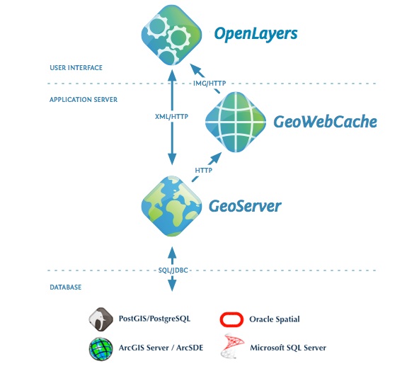
  • Integration with QGIS and GeoServer: you’ll learn how GeoNode works with other open-source GIS tools and how to set up a robust data infrastructure.

Whether you want to build a spatial data infrastructure (SDI), make datasets accessible to colleagues, or develop a geoportal for a wider audience—this course gives you all the tools you need to achieve immediate results.

Why choose the GeoNode Basic Course

This course offers something unique: a comprehensive introduction to an open-source platform that combines data management, publishing, and sharing into a single workflow. While many training courses focus on individual GIS tools, here you’ll learn how to set up a fully-fledged geo-infrastructure using free software.

Everything is explained step by step, with clear examples and practical assignments. You don’t need any programming knowledge: the focus is on usage, management, and application.

The course is designed for professionals and students who work with geodata or want to learn how to make it accessible and usable. From urban planners and GIS specialists to researchers and policymakers—anyone who wants to share and use geoinformation in a modern environment will benefit from this training.

Who is this course intended for?

This course is intended for anyone who wants to learn how to manage and publish geographic data online. Do you work in urban planning, environmental management, research, education, or international cooperation? Then GeoNode gives you the tools to share data and strengthen collaboration.

Read more

Enroll

€1095,- (VAT included)
  • Course duration: 2 days
Register for this course

GeoNode Basic Daily Schedule

Day 1 – Introduction and Basic Usage

On the first day, you’ll be introduced to GeoNode and learn the basics of the platform. We’ll cover the interface, user management, roles, and permissions. You’ll upload datasets and maps, customize styles, and add metadata. You’ll also learn how to search for, combine, and share information within GeoNode. By the end of the day, participants will understand GeoNode’s core functionalities and be able to publish and manage data on their own.

Day 2 – Advanced Use and Collaboration

The second day is dedicated to in-depth learning. You will learn how to work with access rights, version control, and collaboration workflows. We will also cover integration with QGIS and GeoServer, and how to use GeoNode as a full-fledged spatial data infrastructure (SDI). Finally, you will set up and present a small use case yourself. After this day, participants will be able to use GeoNode in a professional environment, set up data infrastructures, and organize collaboration.

Course duration: 2 dagen
Sign me up

Learning Objectives: GeoNode Basics

  • Understanding and Using GeoNode – Participants can navigate the GeoNode interface, upload datasets, publish maps, and manage metadata.
  • Applying user management – Participants know how to set up accounts, roles, and access rights to organize collaboration and security.
  • Integration with other tools – Participants understand how GeoNode works with GeoServer and QGIS, and can utilize these integrations in practice.
  • Putting GeoNode into practice – Participants can set up a simple geoportal or spatial data infrastructure and apply it in their own work context.

Want to know more?

Do you have questions about the course content? Or are you unsure whether the course aligns with your learning goals or preferences? Would you prefer an in-house or private course? We’d be happy to help.

Other courses

Frequently Asked Questions About the GeoNode Basic Course

No, you don't need any programming knowledge. Basic experience with GIS (such as QGIS or ArcGIS) is helpful, but not required. Everything is explained step by step.

No, during the course we’ll be working in a pre-configured training environment. You’ll also receive instructions on how to install and use GeoNode on your own later on.


The course is designed for GIS professionals, researchers, policymakers, and anyone who wants to manage, publish, and share geographic data via a geoportal.

After completing the course, you will be able to independently publish datasets and maps, manage users and permissions, add metadata, and use GeoNode as the foundation for a spatial data infrastructure.

Yes, more and more governments and companies are opting for this portal. U.S. companies such as Esri are still subject to the U.S. Cloud Act. We will therefore have to choose different solutions in the Netherlands and train the next generation of Geo-ICT professionals in those solutions.

The U.S. Cloud Act can compel Esri to hand over data to U.S. authorities, even if that data is physically located in Europe. As long as the software vendor has a U.S. parent company, a legal link to the U.S. remains.

Open-source alternatives offer not only technical flexibility but also legal independence.