
Surveyors and surveying draftsmen often work with the BGT. What are the BGT and IMGEO, and how do they affect their work?
In the BGT course for surveyors, participants receive training on how to enter and maintain data in the BGT.
Geodesie
Surveyors and surveying draftsmen often work with the BGT. What are the BGT and IMGEO, and how do they affect their work?
In the BGT course for surveyors, participants receive training on how to enter and maintain data in the BGT.
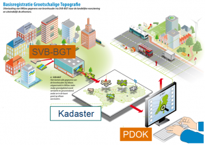 Imagine a digital map of the Netherlands so detailed that every building, every road, every body of water, and even every tree is recorded with unprecedented precision. This is not a pipe dream, but the reality of the Large-Scale Topography Database (BGT). The BGT forms the backbone of geoinformation in the Netherlands. It is an indispensable link for anyone involved in the planning and management of the built environment.
From surveyors to urban planners, from municipalities to engineering firms, the BGT offers a clear picture of reality. This large-scale digital map, at a scale of 1:500 to 1:5000, records the location of all physical objects in detail. This includes not only buildings and roads, but also waterways, rail lines, and green spaces. The accuracy of this map, with details down to 20 centimeters, makes it a powerful tool for both planning and management.
Why is the BGT so important for surveyors? Well, the answer lies in its precision and unambiguity. In the world of geoinformation and surveying, accurate data is worth its weight in gold. The BGT offers this accuracy. This allows surveyors to perform their work with greater certainty and a smaller margin of error. Whether surveying boundaries, determining property characteristics, or planning a new construction project: the BGT ensures you have a solid footing in a world that is constantly changing.
The BGT is updated by municipalities, provinces, water boards, and the Land Registry. It remains current and reflects the changing landscape of our country. For surveyors and geo-professionals, this is an essential source of information, allowing them to plan their projects not only based on the current state of affairs but also with an eye toward the future.
For those new to surveying, we recommend first taking our Surveying Course.
Let’s dive into exactly what the BGT is and why it is such a crucial tool for professionals in geoinformation and surveying.
The BGT is not just a map; it is the base map of the Netherlands. Essential for the planning and management of our living environment. This registry is a collection of data on everything you can find in the outdoor space. From the smallest park to the largest buildings, everything is recorded with extreme precision. Here are some key points that define the BGT:
The use of the BGT extends across various domains:
For surveyors and geo-professionals, the BGT offers unparalleled possibilities. It enables you to work with confidence, knowing that you have access to the most accurate and up-to-date data. This is especially important in projects where every centimeter counts—from surveying new parcels to modifying existing infrastructure.
In essence, the Large-Scale Topography Database provides a solid foundation for anyone working in the field of geoinformation and surveying.
Surveyors play a crucial role in accurately mapping and managing our physical world. For them, the BGT is not just a tool, but an indispensable ally in accomplishing this task. Why is the BGT so important for surveyors? Here are a few reasons:
Furthermore, the use of the BGT by surveyors brings a number of specific benefits:
The importance of the BGT for surveyors cannot be overstated. It goes beyond simply having a map; it is about having a dynamic, accurate, and reliable tool that forms the foundation for all their work.
The BGT records all kinds of outdoor objects in the Netherlands in detail. But what exactly are these objects, and what is their significance? Every object in the BGT has a specific function and contributes to an accurate representation of the real world on digital maps. Here is a brief overview of some key objects and their importance:
However, the BGT goes beyond just these basic objects. Smaller, but equally important elements are also recorded, such as:
Understanding BGT objects and their significance is essential for anyone working with geodata and geoinformation. It enables surveyors, planners, and other professionals to conduct accurate analyses and make informed decisions.
Surveying boundaries and determining object characteristics ensure the accuracy and reliability of the geographic data we rely on for planning, development, and management of the built environment. Let’s delve deeper into what these tasks entail and why they are so important:
These activities are not only technically challenging but also fundamental to ensuring the integrity of our geoinformation. Surveying boundaries and determining object characteristics require a high degree of precision and expertise. Surveyors use advanced technologies such as GPS, digital mapping techniques, and drones.
Key aspects involved in these processes include:
By using the BGT as a foundation, surveyors can not only perform their work with confidence but also contribute to the continuous improvement of this essential national dataset.
The BGT catalog plays a crucial role in ensuring the quality and consistency of data within the Large-Scale Topography Base Registry (BGT). This catalog, also known as the data catalog, forms the heart of the BGT system and ensures that all geoinformation is recorded and shared according to the same standards. But what exactly does the BGT catalog entail, and how is it applied? Let’s dive deeper into the concept and application of this essential resource.
The BGT catalog contains detailed definitions of:
The application of the BGT catalog ensures that:
Essentially, the BGT catalog serves as an indispensable guide for anyone involved in working with and managing geographic information in the Netherlands. Through a deep understanding and correct application of the BGT catalog, professionals in the field of geoinformation can elevate their work to a higher level. With data that is not only accurate and reliable but also widely applicable and accessible for various purposes.
Surveying projects involve much more than just handling measuring equipment. Practical skills are essential for successfully carrying out projects. These skills encompass a wide range of competencies, from technical proficiency to communication and problem-solving. Let’s take a closer look at some of these crucial skills:
In addition, there are several specific practical skills that are of great importance in surveying projects:
These practical skills form the foundation for success in surveying projects. They enable surveyors to collect accurate and reliable data, which is crucial for a wide range of applications in planning, development, and management of the physical environment.
Choosing our BGT Course for Surveyors at Geo-ICT is a choice for quality and practical applicability. This course stands out due to several key aspects that are essential for both novice and experienced surveyors. Here are a few reasons why our course is the ideal choice:
This course is designed to thoroughly prepare you for the challenges and opportunities within surveying and geoinformation. By enrolling, you are choosing a future in which you can confidently and expertly apply the principles of the BGT and IMGEO in practice.
The day consists of a concise overview of the BGT. The contents of the BGT catalog and IMGEO will be discussed. You will learn what BGT objects are, how object boundaries are defined, how they are surveyed, and how attributes are recorded.

Do you have questions about the course content? Or are you unsure whether the course aligns with your learning goals or preferences? Would you prefer an in-house or private course? We’d be happy to help.
This course provides an understanding of BGT objects, IMGEO, and the mapping between BGT and IMGEO.
The course is suitable for surveyors, surveying draftsmen, and professionals who work with BGT data.
Key topics include surveying boundaries, understanding the BGT catalog, and classifying object attributes.
This is a one-day intensive training course designed to help you quickly gain practical knowledge.
You will learn practical skills such as surveying property lines and applying BGT knowledge in surveying projects.
Yes, the course is designed for both beginners and experienced professionals who want to expand their knowledge of BGT.