Immerse yourself in the world of hydrography and discover how you can use this knowledge to make a difference in the world of geoinformation. Whether you’re interested in environmental protection, maritime safety, or the development of new navigation technologies, this course provides the foundation you need to succeed. Enroll today and take the first step toward an exciting career in hydrography.
Would you like to continue your education to become a hydrographer after completing the course? Then you can enroll in the certified CAT B Hydrography program.
The Importance of Hydrography in Our World
Hydrography is central to a multitude of sectors that form the backbone of our modern society. The importance of this science cannot be overstated, not only for shipping and maritime activities but also for environmental research and management. Below, we explore some key points that underscore the vital importance of hydrography in our world.
- Safe and Efficient Shipping: Hydrographic surveys and charts are indispensable for shipping. They provide detailed information about the seabed. This allows ships to navigate safely, reducing the risk of collisions with underwater obstacles.
- Environmental Protection: By studying the physical characteristics of water bodies, hydrographers can contribute to environmental protection initiatives. They help identify vulnerable ecosystems and support efforts to conserve marine habitats.
- Support for Offshore Activities: Whether it involves oil and gas extraction, offshore wind energy, or undersea mining, hydrography plays a crucial role in planning and safely carrying out these activities.
- Coastal Management and Planning: Hydrographic data is essential for coastal management, including erosion control, flood management, and the development of coastal defense structures.
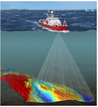
The integration of advanced technologies such as sonar systems and satellite imagery has significantly improved the accuracy and efficiency of hydrographic surveys. These technological advancements enable the collection of real-time data on changing maritime and aquatic environments, which is crucial for:
- Navigation and Charting: Improving the accuracy of nautical charts, which directly benefits safety at sea.
- Depth Surveys: Providing essential insights into the depth of water bodies for navigation, research, and development.
- Hydrographic Data Processing: Analyzing and interpreting data to produce detailed maps and models used in various geodata applications.
By participating in this course, you will not only gain a solid foundation in this important science, but you will also contribute to the safety, economy, and environmental protection of our planet. Geo-ICT provides you with the tools and knowledge to make a difference in the fascinating world of geoinformation and hydrography.
By delving into hydrography, you become part of an essential community that is paving the way toward a more sustainable and safer world. This makes the program indispensable not only for professionals in the maritime sector but for anyone interested in the future of our planet.
Key concepts of hydrography you will learn
As you dive into the world of hydrography with the Introduction to Hydrography Course at Geo-ICT, you’ll be introduced to a series of key concepts. These are essential for anyone who wants to delve into this fascinating field. These key concepts form the foundation upon which you’ll build your knowledge and skills in hydrography. Let’s take a closer look at some of these concepts:
- Depth measurements: Learning to measure the depth of bodies of water is fundamental. You will be introduced to various techniques and instruments such as sonar systems and echo sounders.
- Navigation equipment: A thorough understanding of the equipment used for navigation on the water is crucial. This includes GPS systems, compasses, and other technologies that help determine location and course.
- Chart Projection and Interpretation: The ability to read and interpret hydrographic charts is invaluable.
- Hydrographic Data Processing: After collecting data, processing and interpreting it is essential. You will learn how to convert raw data into usable information, such as creating depth charts and seabed models.
Beyond these technical skills, the course will also provide insight into how these concepts are applied in practical scenarios, such as:
- Environmental Protection: The use of hydrography to monitor and protect aquatic ecosystems.
- Coastal management: How hydrographic data aids in coastal management and erosion prevention.
- Maritime Planning: The role of hydrography in planning safe shipping routes and supporting maritime construction projects.
The Introduction to Hydrography Course not only familiarizes you with the fundamental principles and techniques of hydrography, but also prepares you to apply this knowledge in a wide range of professional settings. It is your springboard to a future where you can navigate the fascinating world of hydrography with confidence and expertise.
What You Will Learn in the Introduction to Hydrography Course
Gain practical skills and knowledge
One of the greatest benefits of the Introduction to Hydrography Course at Geo-ICT is its focus on developing practical skills and knowledge that you can immediately apply in your work or studies. This course is not just a theoretical dive into the world of hydrography, but also a hands-on experience that prepares you for the real challenges in the field. Here are some key areas where you will develop practical skills:
- Use of Technological Instruments: You’ll learn to work with the latest sonar systems and depth sounders, essential tools for any hydrographer.
- Data Analysis and Interpretation: The ability to analyze and interpret collected data is crucial. You’ll learn how to convert this data into actionable information for projects.
- Fieldwork: The course includes hands-on experiences where you’ll learn how to take measurements and collect data in real-world scenarios.
Beyond these technical skills, the course also emphasizes developing a deep understanding of the applications of hydrography across various sectors:
- Maritime Safety: Ensuring safe navigation by mapping potential underwater hazards.
- Environmental Studies: Using hydrographic data for environmental management and the protection of aquatic ecosystems.
- Supporting Offshore Activities: Whether it involves oil and gas extraction or the construction of offshore wind farms, you’ll learn how hydrography contributes to the success of these projects.
By taking this course at Geo-ICT, you’ll not only gain access to the knowledge and skills used by professionals, but you’ll also develop the ability to apply them in practice. This prepares you for a wide range of career opportunities in the geoinformation and geodata sector, from environmental protection to maritime planning and coastal management.
Applications of hydrography in various sectors
The versatility of hydrography makes it an indispensable element in various sectors, from maritime navigation to environmental protection. This course highlights the broad applicability of hydrographic knowledge and skills. Below, we explore how hydrography is applied in various fields and the impact it has:
- Maritime Navigation: The most direct application of hydrography is in shipping, where it ensures safe and efficient navigation. Using detailed hydrographic charts, ships can plan their routes to avoid obstacles and hazards.
- Offshore Industry: In sectors such as offshore oil and gas extraction, wind energy, and undersea mining, hydrographic information is crucial for planning installations and maintaining structures.
- Environmental Studies and Protection: Hydrography plays a key role in monitoring aquatic ecosystems and supporting environmental protection efforts. It helps identify changes in water bodies that may indicate environmental disturbances or the need for protective measures.
- Coastal management: Hydrographic data is indispensable for the planning and implementation of coastal defense works and erosion management. It provides the information needed to design dikes, seawalls, and other protective structures.
By understanding the broad applications of hydrography, you gain insight into how this discipline supports maritime safety, the protection of the marine environment, and economic activities in the maritime and offshore sectors. With this course, Geo-ICT offers a comprehensive introduction to the world of hydrography, where you will not only learn about the theory but also how to apply this knowledge in practice. This opens doors to a career in which you can use geoinformation and geodata to make a significant contribution to addressing various societal and economic challenges.
Why choose our Introduction to Hydrography Course?
Choosing a training program is an important step in your professional and personal development. At Geo-ICT, we understand this, which is why we offer an Introduction to Hydrography Course that is not only informative and challenging but also provides immediately applicable skills. Here are a few reasons why our course is the right choice for anyone interested in hydrography:
- Expert Instructors: Our instructors are not only experts in their field but also passionate about sharing their knowledge. They bring years of practical experience to the classroom, enriching the learning experience.
- Practical Approach: We strongly believe in learning by doing. That’s why our course includes hands-on projects and fieldwork, giving you the chance to put theory into practice.
- Small Class Sizes: At Geo-ICT, we ensure that our class sizes remain small so that every student receives the attention they deserve. This fosters an interactive learning environment where you are free to ask questions and engage in discussion with your instructors and fellow students.
- State-of-the-Art Technology: During the course, you’ll have access to the latest technologies and software in hydrography. This allows you to become familiar with the tools you’ll use in your future career.
Choosing the Introduction to Hydrography Course at Geo-ICT means choosing a program that not only provides you with the theoretical knowledge you need but also prepares you for the practical challenges of working in hydrography. Whether you want to start your career or further develop your skills in this exciting field, our course provides you with the tools, knowledge, and support to achieve your goals. Enroll today and take the first step toward a successful future in hydrography.