
In the Python Geodesy course, you will learn how to use the Python library PyGeodesy for geodetic calculations and for working with coordinates, distances, and projections.
Geodesie
In the Python Geodesy course, you will learn how to use the Python library PyGeodesy for geodetic calculations and for working with coordinates, distances, and projections.
 In the world of programming, the Python package PyGeodesy offers a powerful and accessible way to perform accurate geodetic calculations. This library, based on mathematical and geodetic formulas, enables developers and geo-professionals to work with coordinates, distances, and projections with a high degree of precision. Python PyGeodesy plays a central role in applications such as navigation, geoinformation, and location analysis, where calculations involving distances, bearings, and area determinations are essential.
The true power of PyGeodesy lies in its versatility and accuracy. Starting with simple calculations such as determining the distance between two GPS coordinates, users can gradually perform more complex tasks such as working with ellipsoids (WGS84), converting between coordinate systems, or analyzing polygons and areas. This step-by-step progression in complexity, managed within a practical and consistent environment, makes PyGeodesy an ideal choice for both beginners in geodata analysis and experienced developers working on advanced GIS and navigation projects.
At Geo-ICT, we understand the value of hands-on learning, especially when it comes to mastering geographic calculations with Python. Our Python PyGeodesy Course is designed to guide you through the fundamentals of this library, from basic concepts to more advanced techniques. Through hands-on sessions and project-based learning, you’ll not only gain insight into the theoretical aspects of PyGeodesy but also develop the skills to apply geographic calculations independently.
New to Python? Then the basic Python programming course might be just what you need!
When exploring geodetic calculations with Python, PyGeodesy is known as a fundamental toolkit upon which many successful GIS and navigation applications are built. Understanding these essential components can help you work effectively and efficiently with geodata. At Geo-ICT, we focus on providing in-depth knowledge and practical skills essential for building robust applications with Python and PyGeodesy. Let’s take a look at some of the key aspects:
Distance Calculation: The heart of many PyGeodesy applications. Various methods make it possible to:
Coordinate conversion: PyGeodesy supports various conversions, such as:
Polygons and Area Calculations: Essential for GIS applications, including:
In our Python Geodesy Course, we dive deep into each of these aspects, so that you not only learn how to use them but also understand how they work together to enable dynamic and accurate geodetic calculations.
At the heart of every geographic calculation with Python PyGeodesy lie coordinates and distance measurement. These fundamental elements form the building blocks of your geo-analysis. This makes it essential to understand their role and capabilities. At Geo-ICT, we place a strong emphasis on the practical application of these basic elements, so you can tackle your geo-projects with confidence and skill.
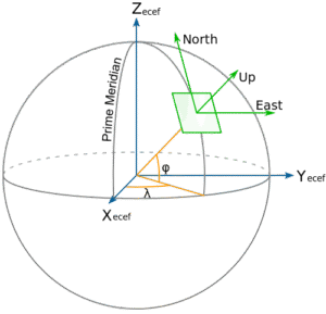
Coordinates are at the heart of geoinformation. With PyGeodesy, you can work with:
Distances are often the first application in geodata analysis. Some examples include:
The moment has arrived: you’re about to perform your first geodetic calculations with Python PyGeodesy. At Geo-ICT, we support you through every stage of this process, from initial concepts to final implementation. Here are some crucial steps and considerations to get you started:
By performing your own calculations, you not only gain practical experience but also develop a deeper understanding of how geoinformation is processed and applied. This is your chance to bring the theory to life and take a step closer to becoming a geoinformation professional.
After laying a solid foundation with your first calculations, it’s time to take your skills to the next level by exploring advanced applications and functionalities. At Geo-ICT, we encourage you to push the boundaries of your creativity and fully harness the power of Python PyGeodesy. Below are some advanced aspects you can integrate into your future projects:
The possibilities with Python PyGeodesy are nearly limitless, and by exploring these advanced techniques, you can develop professional-quality geo-applications.
Choosing a course is an important step in your development as a geo-professional. And at Geo-ICT, we understand that you want the best learning path available. Our Python PyGeodesy Course stands out for several reasons, all of which are focused on providing a learning experience that is not only educational but also truly prepares you for real-world practice. Here are some key reasons why our course is the right choice for you:
Choosing our Python Geodesy Course means choosing a learning path that not only provides you with the technical knowledge you need but also offers the practical experience essential for your success in the world of programming and geoinformation. At Geo-ICT, you’re not just taking steps toward learning a new skill. You’re taking steps toward a new future. Discover the possibilities, sign up, and start your journey to success with Geo-ICT.

Do you have questions about the course content? Or are you unsure whether the course aligns with your learning goals or preferences? Would you prefer an in-house or private course? We’d be happy to help.
A basic knowledge of Python is required, but GIS experience is not necessary. The course provides an introduction to the most important geodetic concepts (such as WGS84, ellipsoids, and coordinate systems), which you will immediately apply in practical exercises.
PyGeodesy gives you, as a developer, greater flexibility and precision. You work directly in Python, allowing you to automate complex calculations, combine them with other data analysis libraries (such as Pandas or GeoPandas), and integrate them into your own applications or workflows.
After completing the course, you will be able to calculate distances and bearings, transform coordinates (for example, from WGS84 to UTM or MGRS), analyze polygons, determine areas, and model routes. This will equip you with a toolkit that has broad applications in geoinformation and navigation.
The course is highly practical: in addition to theory, you’ll work with realistic datasets and assignments. You’ll learn the key features of PyGeodesy by performing calculations yourself and will build a mini-project in which you apply your new skills.