
Sea levels are rising, and so is the ground. This has consequences for buildings, bridges, culverts, locks, quay walls—in fact, for all structures in public spaces. The geodata monitoring course provides the skills needed to identify problems.
Geodesie
Sea levels are rising, and so is the ground. This has consequences for buildings, bridges, culverts, locks, quay walls—in fact, for all structures in public spaces. The geodata monitoring course provides the skills needed to identify problems.
 In today’s world, where technology and data are inextricably linked, geodata monitoring plays a crucial role in how we understand and influence our world. From tracking changes in our climate in real time to accurately monitoring urban development. Geodata provides us with the tools to make decisions that have an impact not only today but also in the future. But what exactly is geodata monitoring, and why is it so important?
Geodata monitoring involves the systematic collection, analysis, and visualization of geographic information that reflects changes over time. This information is collected using various technologies, including satellites, drones, and robotic total stations. Together, these form a detailed picture of our physical world. By analyzing this data, we can not only better understand our environment but also take proactive action in the event of abnormal measurements or unforeseen events.
An important aspect of geodata monitoring is its real-time monitoring capability. Thanks to developments in the Internet of Things (IoT), data can now be collected and analyzed faster than ever before. This opens the door to immediate responses to changes in our environment—whether it concerns the stability of buildings during construction or the health of an ecosystem threatened by pollution.
For processing spatial data and analyses with Python, the Python Geospatial course might be a better fit!
In a world where the boundaries of technology are constantly being pushed, geodata monitoring is central to many of the innovations shaping our society. It’s not just a matter of collecting data. It’s about interpreting and applying it in ways that improve our quality of life, protect our planet, and prepare us for the future. Let’s take a look at some key areas where geodata monitoring plays an indispensable role:
The integration of geodata into modern technologies such as IoT, robotics, and artificial intelligence has taken these applications to the next level. Consider, for example:
Geo-ICT’s role in all of this is to offer a program that not only teaches the technical skills needed for geodata monitoring but also provides insight into how these skills can be applied to solve real-world problems.
To fully harness the power of geodata monitoring, it is essential to understand the basic principles underlying this technology. These principles form the foundation upon which all advanced applications and technologies are built. Below, we explore some of the core concepts:
The application of these principles enables a wide range of possibilities, such as:
The Geodata Monitoring Course covers these fundamentals in depth. This gives students a solid understanding of how geodata can be applied in the real world.
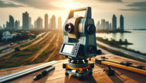
At the heart of modern geodata monitoring technologies lie Robotical Total Stations (RTS). These advanced devices combine electronic distance measurement with angle measurements to determine highly accurate 3D positions of points. But what makes RTS so revolutionary in the field of geodata, and how are they applied?
Robotical Total Stations are the backbone of many geodata monitoring projects, thanks to their ability to collect data with high precision. This precision is crucial in a wide range of applications:
In this course, participants will not only learn how to operate an RTS but will also gain insight into how this technology can be applied to solve real-world problems. This includes:
Through this practical knowledge, students in the Geodata Monitoring program will not only become proficient in using RTS but will also understand its broader applications in the field of geodata.
In the world of geodata monitoring, the emergence of Internet of Things (IoT) technologies has been a game-changer. IoT enables devices to collect and communicate data in real time. This has particularly impressive applications in geodata monitoring, where speed and accuracy are often critical. Let’s take a closer look at how IoT has transformed the way we monitor our world:
The power of IoT in geodata monitoring manifests itself in several remarkable applications:
The integration of IoT into geodata monitoring not only enables real-time data collection; it also improves the accuracy and efficiency of data analysis. This is due to the ability to collect and integrate large amounts of data from various sources, leading to more informed decision-making and better predictions.
This course focuses specifically on understanding and applying IoT in the field of geodata. Students will learn:
These skills prepare course participants to tackle the challenges and opportunities that the future of geodata monitoring brings.
If you want to enter the world of geodata monitoring or deepen your skills in this field, choosing the right course is crucial. Our Geodata Monitoring training at Geo-ICT stands out in several ways. This makes it an obvious choice for professionals and students who want to stay ahead of technological developments within the geodata sector. But what makes our course so unique and valuable? Here are a few reasons:
By choosing our Geodata Monitoring training at Geo-ICT, you’re taking an important step toward becoming an expert in this rapidly growing field. You’ll not only gain the necessary theoretical knowledge and practical skills, but you’ll also have the opportunity to network with like-minded individuals and industry professionals. We look forward to welcoming you to Geo-ICT, where your future in geodata monitoring begins.
On this day, you will gain an overview of how deformations of objects in the field are monitored. This is done using, among other things, robotic total stations and various types of sensors. Software runs on different types of hardware, and with the “Internet of Things,” it is possible to generate continuous streams of geodata and integrate them into geodata portals. In the data portal, a map-based overview of the sensors and other measuring instruments is displayed for each project. This allows buildings to be monitored in real time during construction work or when foundation issues arise, for example. During monitoring, it is possible to be immediately notified of abnormal measurements, which may indicate deformations.
On this day, you will learn how to use Itero. This is a system for automatically performing deformation measurements using a total station. The total station is equipped with specialized software that automatically locates the set-up prisms and performs and saves measurements in multiple stages. The total station can continue to operate unmanned. Deformation measurements are performed at fixed intervals or at specific times. Thanks to the quick configuration process, Itero is also highly suitable for short-term monitoring, where manned measurements are currently often used. The measurements are processed in the cloud, and the results are immediately accessible to all parties involved via a personal login code. The measurements are displayed per prism in graph or table format. Additional data, such as the compensator setting and temperature, are also shown.
Today’s session will cover the Leica DNA, vibration meters, inclination sensors, and crack width meters. The DNA monitor uses the Leica DNA to continuously and remotely monitor settlement or deformation. This system also provides all relevant personnel with real-time insight into measurement results during test loads, for example. The beacon reading and distance are displayed graphically in the portal. External data sources are added to this, allowing you to immediately see whether factors such as outside temperature or humidity are affecting the object you are measuring. With a short interval of 10 seconds between consecutive measurements, you can closely monitor the vertical movement of objects over long periods, leveraging the high accuracy of the DNA. The long interval ensures that outliers caused by vibrations and similar disturbances can be easily averaged out.
Learn how to apply geodata monitoring to subsidence, cracks, and deformations in structures such as buildings, bridges, and retaining walls. Process these continuous measurements so that well-founded conclusions can be drawn and appropriate actions can be taken. Become familiar with the instruments that can be used for monitoring. Apply tools and techniques to ensure that the continuously collected data is fed into funnels, cloud storage, databases, and machine learning systems.

Do you have questions about the course content? Or are you unsure whether the course aligns with your learning goals or preferences? Would you prefer an in-house or private course? We’d be happy to help.
This course provides comprehensive training in geodata monitoring, including the use of geodata portals and real-time monitoring techniques.
The course is ideal for aspiring geospatial professionals, experienced professionals, companies, people looking to change careers, and educational institutions seeking to expand their knowledge of geodata.
Yes, the course includes hands-on training with Robotical Total Stations, which are essential for modern geodata monitoring.
Absolutely; the course covers the use and management of geodata portals as a core component.
The course explores how the Internet of Things can be applied to geodata monitoring and real-time data analysis.
Yes, the course covers the identification and analysis of outliers in geodata.
Building monitoring is an important topic, in which students learn about monitoring techniques and applications in the construction industry.
This is highly relevant, as the course provides specific skills that can be applied to the monitoring of construction work.
The course covers various geodata software, including specific data portals and monitoring tools.
The course provides in-depth training in the use and management of data portals for geodata monitoring.