
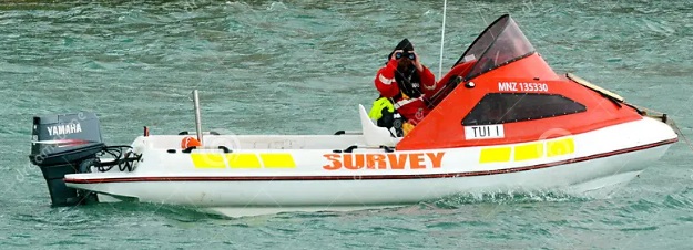
A multibeam hydrographic survey is conducted to map the seabed, riverbeds, or lake beds in order to determine the topography of the underwater surface.
Geodesie
A multibeam hydrographic survey is conducted to map the seabed, riverbeds, or lake beds in order to determine the topography of the underwater surface.
This course is taught online (virtual classroom) in English by Ebelien van der Velde.
For more information in English, download the information PDF.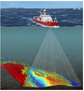
In the fascinating world of hydrography, knowledge of the seabed plays a crucial role—not only for shipping but also for underwater research and environmental conservation. Hydrography revolves around mapping and studying bodies of water, utilizing advanced technologies such as multibeam echo sounder systems to collect depth measurements and topographic data of underwater surfaces. This information is invaluable for creating accurate nautical charts, planning maritime routes, and supporting coastal management and underwater archaeology projects.
Our Multi-Beam Survey Course not only covers the theoretical foundations of hydrographic principles but also places a strong emphasis on practical applications—from operating multi-beam echo sounders to processing bathymetric data. The course prepares you for a range of professional challenges.
The technologies you’ll learn are not only fascinating but also essential for modern geodata collection and analysis. By immersing yourself in this course, you’ll become part of a specialized community that shapes the way we understand our planet. This is your chance to contribute to both geoinformation science and the protection of our marine ecosystems with authoritative knowledge and compelling insights.
Are you ready to explore the depths of hydrography and take your skills to the next level? Geo-ICT is waiting for you with a course that will not only enrich your career but also your perspective on the underwater world.
The fundamentals of hydrography lay the foundation for anyone who wants to understand the complex and fascinating world of seabed mapping. These principles are key to conducting accurate and reliable hydrographic surveys. Here’s a look at what’s essential:
The course at Geo-ICT offers in-depth insight into these and other fundamental aspects of hydrography. You will learn not only about the technical side but also about its application in real-world scenarios. This prepares you for a career in which your work will actively contribute to a better understanding of our water-rich planet.
By embracing this knowledge base, you’ll be equipped with the skills to make essential contributions to geoinformation science, maritime safety, and environmental protection. With Geo-ICT as your guide, you’re at the start of a fascinating journey into the world of hydrography, where every wave and every grain of sand counts.
The technology behind Multi-Beam Survey is truly revolutionary and forms the backbone of modern hydrographic surveys. This technology utilizes advanced sonar systems that simultaneously transmit multiple sound pulses (beams) across a wide area beneath a ship. This enables us to obtain a much more detailed and accurate image of the seabed than was ever possible before.
Some key components of this technology are:
This technology offers unprecedented possibilities for studying the underwater world—from depth measurement and navigation to environmental research and mapping archaeological sites. By delving into our Multi-Beam Survey Course, you’ll not only gain a deep understanding of this technology but also practical experience in using it. This opens new doors to opportunities within the world of geoinformation and hydrography. In doing so, you’ll contribute to important discoveries and help make maritime navigation safer.
Understanding and operating multi-beam echo sounder systems is central to the course. These systems, crucial for modern hydrographic surveys, provide detailed information about the seabed. Some key aspects you will learn include:
This knowledge enables you to confidently participate in projects that require the seabed to be accurately mapped. By developing your skills in using this advanced technology, you enhance your value as a professional in geoinformation and contribute to important discoveries in both science and industry.
Collecting and processing data is a crucial step in the hydrographic survey process. The Multi-Beam Survey Course guides you through the most important techniques and tools. You will learn how to:
These skills are essential for anyone working in the field of geoinformation, as they form the foundation for creating reliable datasets that can be used for navigation, research, and environmental conservation.
Choosing our Multi-Beam Survey Course means opting for an in-depth and hands-on learning experience in the world of hydrography and geoinformation. Here are a few reasons why this course stands out:
This combination of factors makes our course an essential step for anyone who wants to deepen or expand their career in geoinformation science.
The following learning objectives ensure that participants gain a thorough foundation in both the theoretical and practical aspects of multibeam hydrographic surveying, preparing them for a wide range of professional applications.

Do you have questions about the course content? Or are you unsure whether the course aligns with your learning goals or preferences? Would you prefer an in-house or private course? We’d be happy to help.
The Multi-Beam Survey course at Geo-ICT Training Center provides in-depth knowledge and practical experience with multi-beam echo sounder techniques for mapping lake and riverbeds.
This course is ideal for entry-level geospecialists, experienced geoprofessionals, companies in the geospatial sector, individuals seeking career transitions, and educational institutions looking to develop or refine their skills in hydrographic survey techniques.
Participants can earn a certificate that recognizes their knowledge and skills in multi-beam survey techniques, such as depth measurement and water depth mapping.
To participate in the Multi-Beam Survey course, a basic understanding of geographic information systems (GIS) and an interest in marine geography are recommended, but highly motivated beginners are also welcome.