
Virtually all contractors are switching to digital dimensioning. This course provides students with a solid foundation to get started.
Geodesie
Virtually all contractors are switching to digital dimensioning. This course provides students with a solid foundation to get started.
 Surveying has been fundamentally transformed by the advent of digital technologies. At its core, it is a discipline concerned with measuring our environment and mapping the Earth. This involves the use of advanced techniques and tools such as Total Stations, GPS, and Geographic Information Systems (GIS). These instruments have radically transformed the way in which geoinformation is collected, analyzed, and presented.
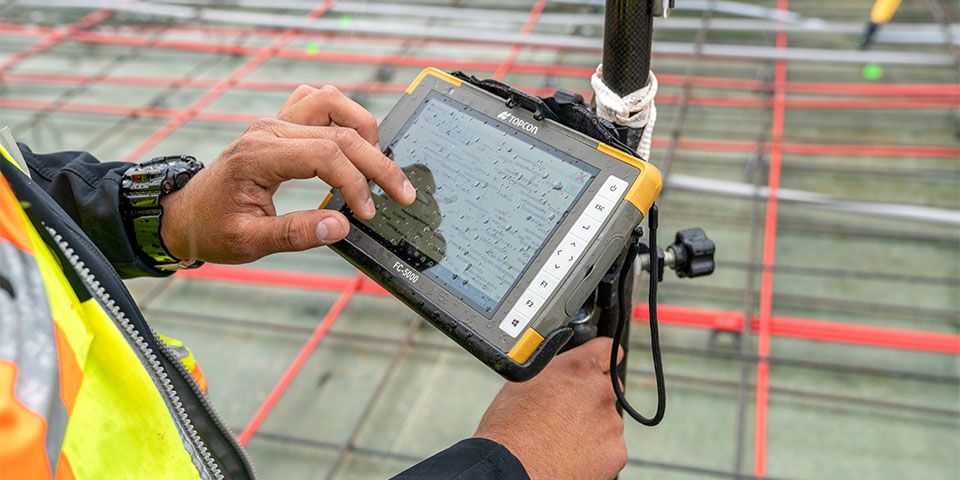
The "Surveying and Staking Out" course serves as a bridge between traditional surveying methods and the modern, digital approach. Participants are not only introduced to the basic concepts of digital surveying but also learn how to effectively apply these technologies in their work. This involves working with the latest versions of project data on their tablets in the field and immediately transferring survey data to the project planner for quick and accurate verification. Real-time updates and the digitization of the workflow between the office and the project site are crucial elements here.
This shift toward digital processes has a significant impact on efficiency and accuracy in surveying. And it offers professionals new opportunities to execute their projects with greater precision and speed. Switching to digital processes doesn’t have to happen all at once throughout the construction process; you can start small. An important step is digitizing the workflow between the office and the project site. This allows field personnel to receive real-time updates on their tablets, ensuring they always work with the latest version. And when survey data from the construction site is immediately transmitted to the work planner in the office, they can immediately verify whether the measurements are complete and accurate.
Also check out the surveying course, where students gain insight into how surveying works. They also actually go out into the field to take measurements using a GPS and a Total Station.
The shift to digital surveying marks a turning point in the world of surveying and geoinformation. This transformation is driven by the need for greater efficiency, accuracy, and the ability to share and update data in real time. Here are some key points of this transition:
These elements not only highlight the technical aspects of the transition but also underscore the importance of a mindset focused on innovation and continuous improvement. By embracing digital surveying, professionals open the door to a new world of possibilities where projects are completed faster, more accurately, and with less effort.
However, the path to digital proficiency requires more than just learning how to use new tools. It’s also about understanding how these technologies can be integrated into daily workflows to increase overall project efficiency. Here at Geo-ICT, we focus on providing a solid foundation and advanced knowledge in digital surveying, so that you, regardless of your experience level, can develop the skills and confidence needed to succeed in the modern geoinformation and geodata landscape.
Digitization plays a crucial role in modernizing the construction process, making projects more efficient, accurate, and cost-effective. The integration of digital technologies such as GIS and BIM (Building Information Modeling) is transforming the way projects are planned, executed, and managed. Key benefits of digitization in the construction process include:
By digitizing the construction process, traditional barriers are broken down and a foundation is laid for future innovations. Geo-ICT understands the importance of this transition and, through the "Measurement and Staking Out" course, offers the knowledge and skills needed to lead this digital revolution. The focus is on equipping professionals with the tools to take their projects to the next level, which is essential in the rapidly evolving world of geoinformation and geodata.
In the transition to digital surveying and the use of advanced digital surveying instruments, understanding the basic principles is key. This knowledge forms the foundation upon which you can build and refine your digital surveying skills. The use of technologies such as Total Stations, GPS, and GIS is revolutionizing the efficiency and accuracy with which geodata is collected and processed.
Mastering these tools and technologies enables you to execute projects with confidence and competence that require data to be both accurate and up-to-date. Geo-ICT offers comprehensive training courses that equip participants with the knowledge and practical experience to navigate this digital transformation in the construction process. It is not just about learning how to operate the instruments, but also about understanding how these technologies can be integrated into your workflows, making your projects more efficient and effective.
Applying surveying techniques and coordination systems in practice is crucial for the precision and effectiveness of surveying projects. These practices include:
These steps provide a strong foundation in digital surveying, essential for every professional in the geoinformation sector.

Do you have questions about the course content? Or are you unsure whether the course aligns with your learning goals or preferences? Would you prefer an in-house or private course? We’d be happy to help.
This course offers a two-day training program in surveying and staking out, focusing on land surveying and digital surveying.
The course is ideal for aspiring geospatial professionals, experienced professionals, companies, people seeking career transitions, and educational institutions.
The course covers the use of total stations and GPS for digital surveying.
The course covers GIS techniques, reading drawings, proper work methods, and survey setups.
The course emphasizes the digitization of the workflow and the importance of real-time updates.
Questions can be submitted via info@geo-ict.nl and during the course.
There is an evaluation portal for feedback, and participants receive a certificate.
Yes, the course is certified by the Dutch Council for Training and Education (NRTO).
The course lasts two days.
There are no specific educational requirements, but some prior knowledge of the geosciences sector is helpful.