
The "Introduction to 3D Geoinformation" course provides project managers, work planners, site supervisors, and other users of survey data with a solid overview and understanding of how to work with 3D geoinformation
Geodesie
The "Introduction to 3D Geoinformation" course provides project managers, work planners, site supervisors, and other users of survey data with a solid overview and understanding of how to work with 3D geoinformation
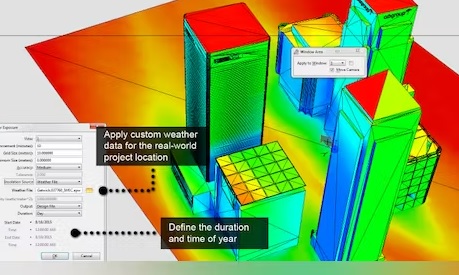
In the fascinating world of 3D geoinformation, a revolution is unfolding that is completely transforming the way we view and use data. Imagine no longer being limited to the flat maps and images of yesterday. Instead, you navigate through dynamic, three-dimensional worlds where every corner, every building, and every terrain is rendered in stunning detail. This innovation opens new doors for analysis, planning, and communication across the board—from urban development to environmental management.
3D geoinformation brings a virtual replica of reality to life. This allows users to visualize and manipulate complex datasets like never before. This advanced approach makes it possible to perform volume calculations, determine sightlines, and even analyze the impact of noise on building facades. The use of 3D geodata is becoming increasingly common across a wide range of sectors, including construction, urban planning, and environmental protection. This significantly enhances the accuracy and transparency of projects.
At Geo-ICT, we recognize the immense potential of 3D geoinformation and strive to equip our students not only with theoretical knowledge but also with the practical skills needed to master this technology. Our Introduction to 3D Geoinformation Course has been carefully designed to guide you through the core concepts of 3D geodata—from the 3D standard in the Netherlands to the relationship between coordinates and 3D models, and how these relate to Building Information Modeling (BIM).
In the course, we delve deeper into the tools and services available for working with 3D geodata, and we highlight the opportunities and challenges associated with their use. We discuss how managing 3D Geo-Information projects can lead to reduced failure costs and the successful completion of projects.
To get started with surveying, we recommend the Surveying Course!
Immerse yourself in the basics of 3D geoinformation and discover how this powerful tool can help you better understand and manage the world around us. The core of this technology lies in its ability to accurately and interactively represent the complexity of the physical world. This offers not only a new way of viewing, but also of interacting with geodata.
Key components of 3D geoinformation:
By taking the Introduction to 3D Geoinformation course at Geo-ICT, you’ll gain access to the following insights and skills:
These building blocks form the foundation upon which our course is built. They not only provide a deep understanding of the subject matter but also enable you to develop practical skills that are directly applicable to your work or studies. Combining theory and practice, our course guides you through the fascinating world of 3D geoinformation. Each lesson is designed to take your knowledge and skills to the next level.
The link between 3D models and the real world is much more than just a technical achievement. It is a bridge that spans the gap between digital information and our physical environment. This relationship offers a unique perspective on how we can interact with the world around us, enhanced by the precision and flexibility of digital models. 3D geoinformation plays a crucial role in this, as it lays the foundation for a deeper understanding and a more informed use of geographic data in three dimensions.
The integration of 3D models with the real world enables a number of innovative applications:
By using 3D geoinformation, you can not only view the world in new ways, but also better understand and manage it. This course provides you with the tools and knowledge to use this technology effectively, enabling you to:
This synergy between 3D models and the real world offers unprecedented opportunities for professionals across various sectors. It enables us to solve complex problems, improve our environment, and ultimately create a more sustainable future.
To fully immerse yourself in the world of 3D geoinformation, it is essential to master the right tools and techniques. These tools enable you not only to create and visualize 3D models, but also to effectively analyze and integrate them into your projects. At Geo-ICT, we focus on providing hands-on experience with leading-edge software and methodologies that have become the industry standard.
Some of the core tools and techniques you will learn to master include:
By mastering these tools and techniques, you can:
At Geo-ICT, we understand the importance of not only theoretical knowledge but also practical skills. That is why this course focuses on providing both the fundamentals and the advanced techniques you need to succeed in the world of 3D geoinformation. Through a combination of expert instruction and hands-on exercises, you’ll be able to use these tools and techniques with confidence in your own projects and career.
Making the transition from theory to practice in the world of 3D geoinformation is a crucial step for professionals who want to leverage this advanced technology to tackle real-world challenges. The knowledge and skills you gain during this course at Geo-ICT form the foundation for this transition. However, it is the practical application that transforms theory into tangible results and innovative solutions.
Practical examples of 3D geoinformation applications:
At Geo-ICT, we emphasize the importance of applying 3D geoinformation in real-world projects. This not only allows you to test your newly acquired knowledge but also to:
The transition from theory to practice in 3D geoinformation requires a deep understanding of both the available tools and their potential applications. In our course, you’ll not only gain access to state-of-the-art software and techniques, but you’ll also learn how to effectively apply them across a wide range of projects. This hands-on learning underscores our commitment to preparing our students for the future. Ready to tackle the challenges and opportunities that 3D geoinformation offers?
When choosing a course to improve your skills in 3D geoinformation, it’s important to select a program that offers not only comprehensive knowledge but also practical skills that can be immediately applied in the field. Our Introduction to 3D Geoinformation Course at Geo-ICT stands out for several reasons:
1. Expert Instructors
Our course is taught by experienced professionals who are actively working in the field of geo-information. This means you’ll learn from people who possess more than just theoretical knowledge; they also have practical experience applying 3D geo-information in various projects.
2. Hands-On Approach
We strongly believe in learning by doing. That is why our course is designed with a focus on hands-on experience. This gives you the opportunity to work with the latest software and technologies. This enables you to:
3. State-of-the-Art Course Materials
Our course materials are always up-to-date with the latest developments and best practices in the industry. This ensures you learn to work with the most current tools and techniques. This is essential in a rapidly evolving field like 3D geoinformation.
4. Broad Applicability
The skills you gain in our course are widely applicable across various sectors—from construction and infrastructure to urban planning and environmental management. This opens up new career opportunities and helps you stand out as a professional.
By choosing our Introduction to 3D Geoinformation Course, you are investing in your future with a course that combines theory and practice, led by expert instructors, and supported by excellent course materials and a support network. At Geo-ICT, we are committed to your success, and we invite you to discover and harness the power of 3D geoinformation with us.
The following topics will be covered in the Introduction to 3D Geoinformation course:
The Introduction to 3D Geoinformation course has the following learning objectives:

Do you have questions about the course content? Or are you unsure whether the course aligns with your learning goals or preferences? Would you prefer an in-house or private course? We’d be happy to help.
You will learn about working with 3D geodata, the 3D standard in the Netherlands, and the relationship between coordinates and 3D models.
The course is designed for both new and experienced geospatial professionals, as well as professionals from other sectors who wish to change careers.
The course covers the relationship between 3D geoinformation and Building Information Modeling (BIM), which is essential for modern construction projects.
The course provides insight into the successful management and completion of 3D geoinformation projects, with a focus on opportunities and risks.
3D geoinformation can help reduce failure costs and improve project efficiency.
A basic understanding of geoinformation is helpful, but the course is also open to beginners.
Yes, upon successful completion, you will receive a certificate, which will be valuable for your professional development.
The Introduction to 3D Geoinformation Course lasts one day.